Introduction
1
Geographic information systems (GIS) are widely used to create various cartographic
works, despite the fact that they are inferior in design to publishing systems. When
compiling atlases, GIS are currently used to perform individual cartographic processes,
such as the development of spatial and thematic databases, creation of thematic maps,
generalization of objects, creation of typical cartographic foundations and individual
thematic maps, and the construction of various thematic surfaces, etc. Among studies on
the use of GIS in the compilation of atlases and atlas information systems, the work of
the Swiss cartographic school (Hurni 2017,Vomsattel et al. 2019) should be noted. Many common GIS
also have a special functionality that allows a map to be cut (inserted) into the pages of
an atlas, enabling the creation of multi-page cartographic works such as city and road
atlases. Geographic, complex (integrated) and thematic atlases are characterized by
complex structures and diverse relationships between their sections (Vozenilek 2019).
Therefore, the use of GIS is limited in terms of creating these types of atlases as
independent cartographic works with holistic structures and full content. Also, depending
on the selected GIS, its technological and functional capabilities, there are different
ways of creating atlases. Currently, the most common is the page-by-page approach, where
the design of each atlas map is conducted in a separate working set, and the integration
of the resulting maps and atlas is performed in the final stage, after the output of
ready-made layouts from the software (Field 2018).
This approach not provide automation of the process of compiling the atlas as a single,
whole cartographic work.
Therefore, it is necessary to consider the features, advantages and disadvantages of
using the most common GIS when creating atlases of various types (geographic, complex and
thematic), propose schemes for the possible organization of such atlases, and develop
technological schemes for their automated creation.
Principles of Atlas Structure Organization
2
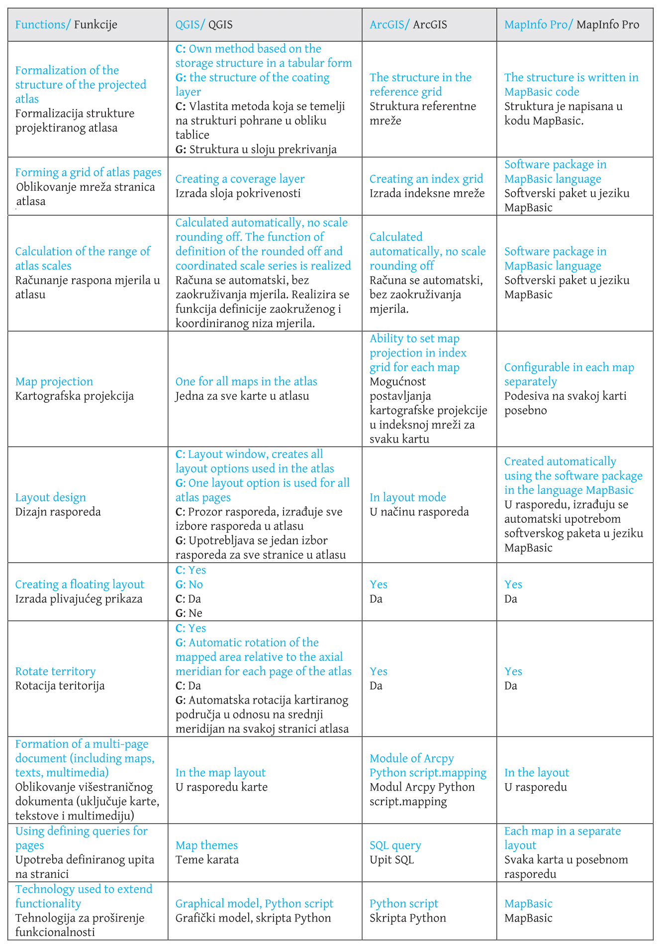
For the study, we selected the QGIS, ArcGIS and MapInfo Pro full-featured geographic
information systems, which have various tools for forming atlas structure and creating
atlas maps. The overall approach to the formation of the atlas in GIS, depending on the
purpose and content of the atlas, may vary. This is primarily due to the different atlas
structures. We will consider each type of atlas in more detail.
General geographical atlases have the same type of content and their structure is
well-established (Svatkova 2002). Hierarchical
ordering allows the atlas to be divided into its component parts. For example, for the
1999 Atlas of the World, the following sections and subsections can be distinguished: 1.
The world as a whole - an introductory section. 2. Russia, continents, oceans - overview
maps. 2.1. Regional maps: 2.1.1. Level 1 subsections - regional overview maps. 2.1.2.
Level 2 subsections - Detailed regional maps (Makarenko et
al. 2017).
Thematic atlases consist mainly of maps of a single subject, showing the spatial
distribution of certain processes or phenomena. The structure of thematic atlases is very
individual (Svatkova 2002). The ordering of the
mapping territory is organized according to the hierarchy of territorial coverage, and
within each territory (section) there is a set of maps.
Complex (integrated) atlases provide systematic information on the full, comprehensive
(polythematic) characteristics of the mapped territory. In these atlases, the constituent
parts (sections) of a complex atlas traditionally form groups of physical maps and
socio-economic maps, which in turn are divided into subsections or themes. “The number of
maps in the atlas and their contents depend on the geographical features of the region,
its knowledge, the availability of materials, and the possibility of their cartographic
use” (Salishchev 1976). The main task in developing
the structure of a complex atlas is to determine the necessary sections and the optimum
list of maps in each section.
Creating Atlases in GIS: Analysis and Solutions
3
Fig. 1 Steps for creating atlases in GIS.
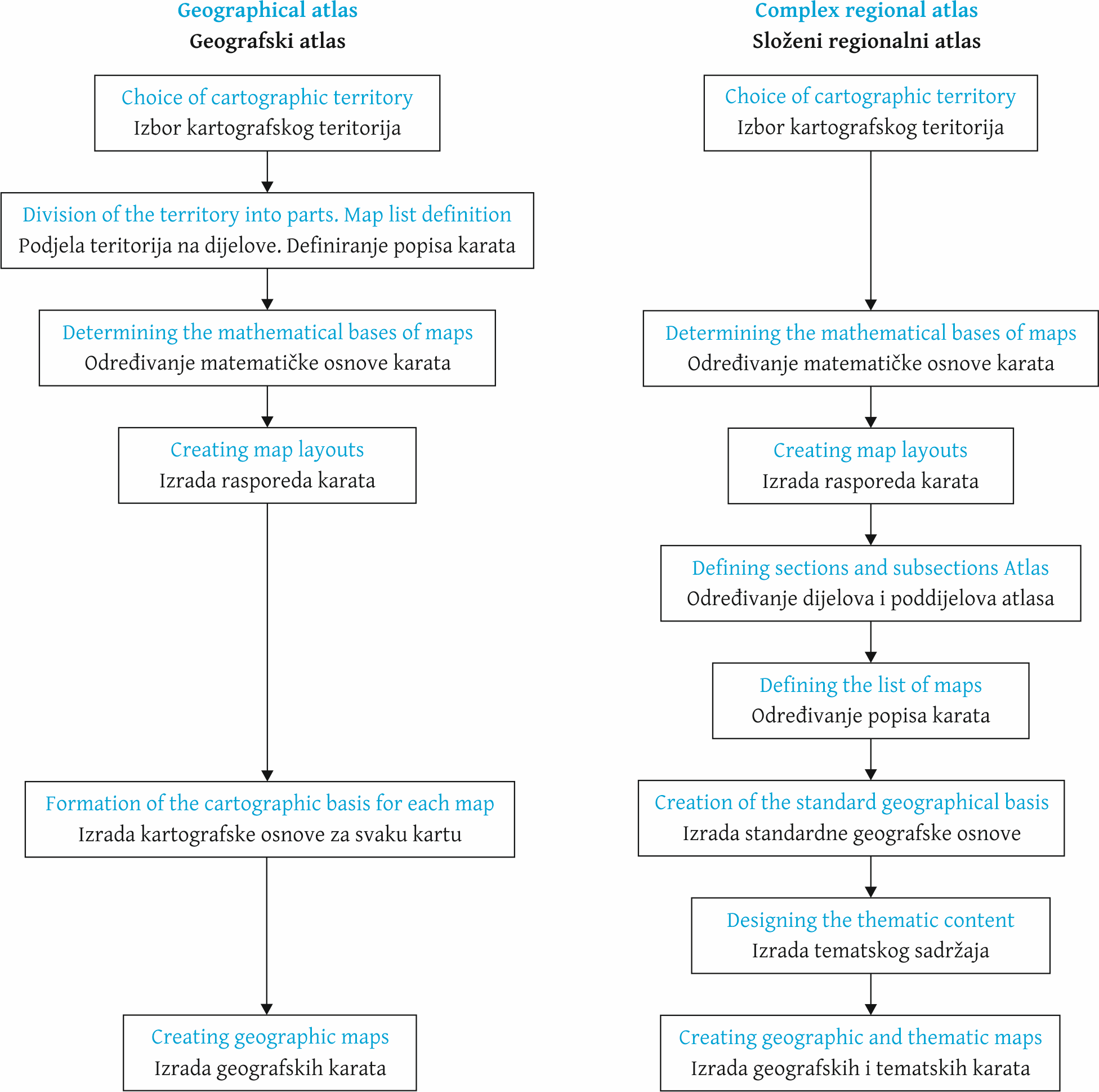
Figure 1 presents the main stages and features of the creation of geographic
information systems and integrated regional atlases.
The main data source for creating an atlas of any type in GIS is a cartographic database
- a set of organized arrays of digital cartographic information and software tools that
provide access to data and their maintenance, storage and issuance (Khalugin et al. 1992). The initial composition of the cartographic
database information (hydrography, settlements, traffic routes and borders) provides the
typical bases of the atlas. The developed system of classification and coding of
geographic objects and a single fixed format for recording digital cartographic
information allow automization of the basic technological processes for creating atlases,
for example, the cartographic generalization of objects.
It should be noted that when designing a geographic atlas, the cartographic database
should be created at the most precise territorial level represented in the atlas. This is
due to the presence of maps of the same content in geographic atlases, made for different
levels of territorial coverage.
When creating thematic or complex regional atlases, besides the cartographic database, it
is necessary to form the thematic database containing quantitative and qualitative
indicators of the mapped object or phenomenon. To create socio-economic maps, the main
source data are statistics.
When creating a thematic database for atlas mapping, it is necessary to develop tables
that take into account all the indicators on all the created thematic maps. At the same
time, depending on the cartographic imaging method used, and therefore the placement of
the mapped phenomenon, it is possible to group the indicators in one table. So, for
objects and phenomena placed in administrative units, it is advisable to create a single
table containing indicators for different methods of cartographic image as well (for
example, for cartograms and cartodiagrams). A separate table is created for objects
localized in settlements. Communication of statistical information with metric information
of layers in the cartographic database is carried out via the unique codes of
administrative units and settlements (for example, for the Russian Federation, the OCTMO
code is used).
For our study, we considered the features of creating geographical, thematic and
integrated atlases in the QGIS, ArcGIS and MapInfo Pro geographic information systems.
This choice of software was due to their wide functionality and prevalence in the Russian
and foreign geographic information services markets.
QGIS
QGIS is a free, full-featured, open-source geographic information system. It is used to
create, edit, visualize, analyze and publish geospatial information.
The formation and configuration of the atlas in QGIS based on the layers opened in the
project takes place in the process of creating a layout, which is a separate window with
tools for the creation, design and layout of cartographic works. To do this, the layout
window provides a separate tab Atlas (Atlas-Atlas Settings) with a set
of the following functions
enable atlas generation option
select a layer and objects in it, on the basis of which the map will be divided
into sheets (Coverage layer, Filter with)
define a table field or specify an expression by which the atlas pages will be
sorted
specify a file name when exporting the atlas to external data formats
.
Navigating through the pages of the atlas is done using the menu command Atlas
- Preview Atlas, and this function must be activated every time you change
the content of the layout. The menu also contains tools to print the atlas, export the
atlas pages as a bitmap, and save the atlas pages in SVG and PDF format.
The display settings for the selected elements of the layout pages (maps, legends,
etc.) are set using the functions of the standard tab Item Properties.
For maps, you can set the coordinate system, the rotation angle of the map, or create a
map grid, etc. At the same time, it is possible to establish a single coordinate system
and, accordingly, a single cartographic projection for atlas maps, which means QGIS
cannot create some geographical and thematic atlases which use several different
projections for different territories (for example, world atlases).
For geographical atlases of the Russian Federation, it is possible to use a single
cartographic projection on the entire mapping territory. So it is possible to use a
class of conical projections, while the change of the axial meridian for each subject is
not carried out in the parameters of the coordinate system, but by simply rotating the
map at an angle calculated as the difference between the axial meridian of the entire
territory and the longitude of the centroid of the subject. This requires additional
calculations.
Item Properties also specifically enables atlas creation under the
option Controlled by atlas, which allows the user to select one of the
following options to define the scale for the pages of the atlas: generating a scale
taking into account the space used in division of atlas objects (Margin around
feature); automatic calculation of scale range (Predefined scale
(best fit)); and setting a fixed single scale (Fixed scale).
Experiments have shown that it is impossible to use this QGIS functionality when
creating geographic and complex atlases. So, in the first case, the scale for each page
of the atlas is unique and not rounded off, and this does not automatically generate the
correct scale series of the atlas. In the second variant, there is a strong degree of
rounding off. The use of a fixed scale does not meet the design requirements of an atlas
as a map system.
Thus, we can draw the following conclusion. QGIS has advanced functionality to
customize the layouts of cartographic works, allowing the quick creation of maps on each
page of the atlas. Thus for geographical atlases, the identical contents for different
mapped territories are formed, while for complex regional atlases, the different
thematic contents for the same territory are formed. QGIS also allows the creation of a
single style of atlas page.
However, the creation of geographic, thematic, and complex atlases in QGIS is limited
by the following software flaws:
inability to calculate and correctly round off the scale of maps for different
sizes of territories
the absence of a choice of a coordinate system for each individual map
the need to calculate the rotation angle for each map of the atlas
the time-consuming process of creating floating layout maps
.
Therefore, the authors propose solutions to improve the process of creating general
geographic and complex regional atlases in QGIS (Figure 2).
Fig. 2 Solutions developed to improve the process of creating geographic and complex
atlases in QGIS.
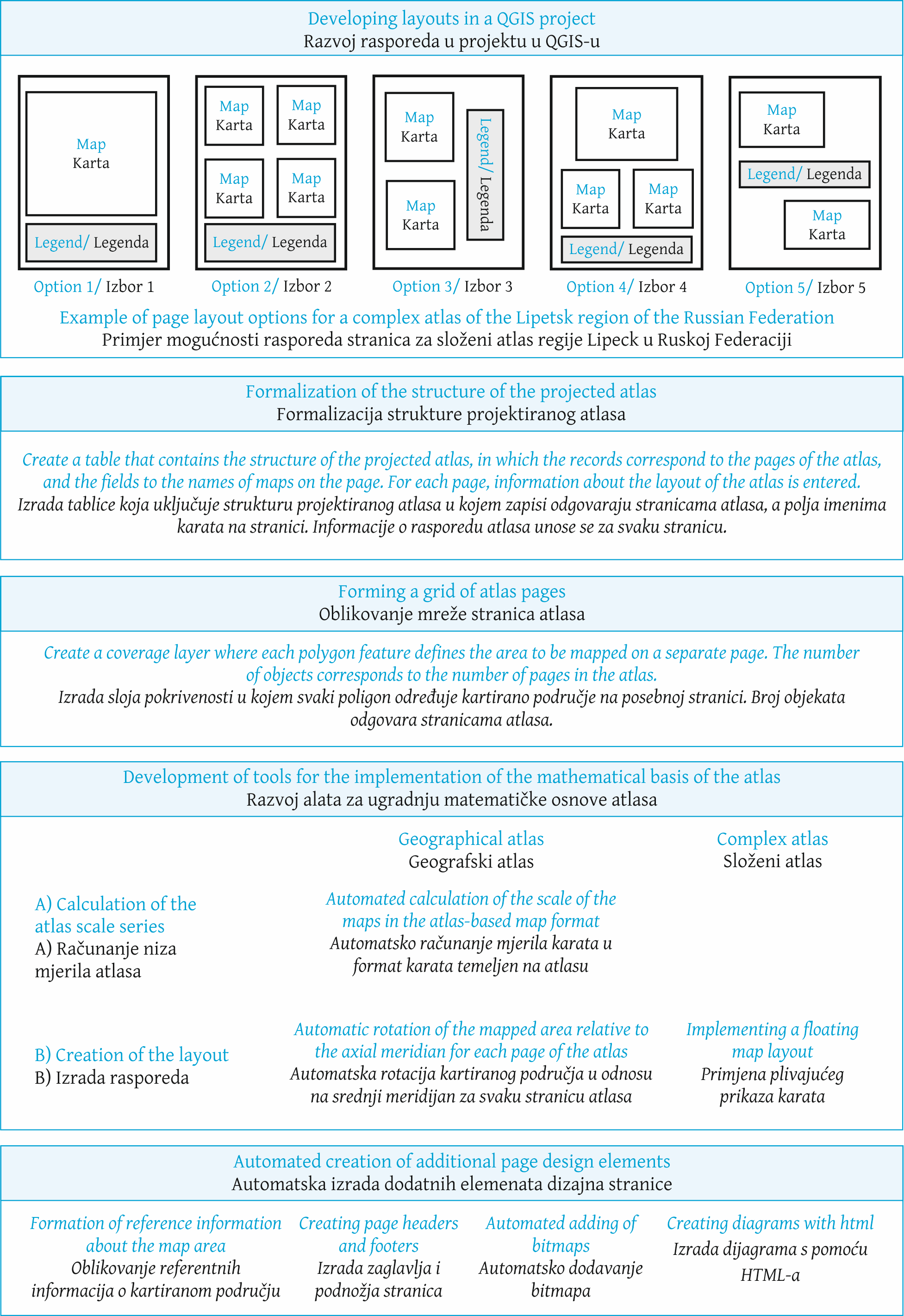
Primarily, these solutions are aimed at formalizing the structure of the
projected atlas and automating the design process of its mathematical basis, including
the definition of a large-scale series of atlas maps (
Zagrebin et al. 2019). A separate block of developments is devoted to the
automated creation of additional elements of the atlas page design - map headers,
footers and additional text information about the mapped territory. It should be noted
that the proposed list of solutions is not final and may be supplemented as modules and
algorithms are developed.
ArcGIS
ESRI's ArcGIS geographic information system is used to build GIS at any level. ArcGIS
enables geographic information to be used, analyzed and understood, leading to better
decision-making and the creation and publication of maps as print versions, desktop
applications, portals, and maps for mobile devices.
In general, QGIS and ArcGIS are similar in functionality and ideology of modules, but
ArcGIS has a more developed toolkit for creating atlases and multi-page maps. The
following features of ArcGIS (ArcGIS 2019) can be
noted, automating the process of creating geographic and complex atlases:
using the Python Arcpy script module.mapping. This module
extends the functionality of multi-page layout and is necessary to create atlas
pages that do not contain maps. When a multipage layout is created on a coverage
layer (index grid), a separate page is created for each grid cell that corresponds
to a separate map, but pages without maps will not be created. At the same time,
the development of atlas mapping and the principles of creating atlases is moving
towards the supply of cartographic material with additional information, such as
cartographic illustrations (Fokin et al.
2016), graphs and diagrams, explanatory text and multimedia files
setting the coordinate system for each window or frame in the map. This allows t
a separate coordinate system to be set for each window of the map, which is
prescribed in a separate field of the index table. The coordinate system is
defined as a text string with three possible entries: a description in WKT format,
a link to an external WKT file, or an EPSG code. This feature allows atlases to be
created with several classes of map projections
using defining queries for pages in the atlas. A defining query allows the SQL
query to be used to limit the display of objects in a separate map window, which
allows the content of each individual map of the Atlas being created to be
controlled
.
MapInfo Pro
GIS MapInfo Pro (developed by Pitney Bowes Software Inc.) is a powerful tool for
working with spatial data and creating maps. The program allows the most complex
problems of geographical analysis to be solved, such as zoning, communication with
remote databases, the inclusion of graphical objects in other applications, the creation
of thematic maps, identifying trends and patterns in the distribution of data and much
more. Data in MapInfo Pro can be presented in the form of maps, lists, legends, graphs
and reports.
The main advantage of MapInfo Pro for use in atlas mapping is the ability to create
multiple maps and reports within a single working set (project). This allows the
creation of a multi-page document using maps with different source data, mathematical
basis and content, which makes MapInfo Pro suitable for creating general geographic,
complex regional and thematic atlases. However, in this case, a large number of maps and
reports are created in one working set, which makes it difficult to navigate internally
in the atlas. This organization of the atlas structure is shown in Figure 3.
Fig. 3 Organization of the atlas structure in MapInfo Pro.
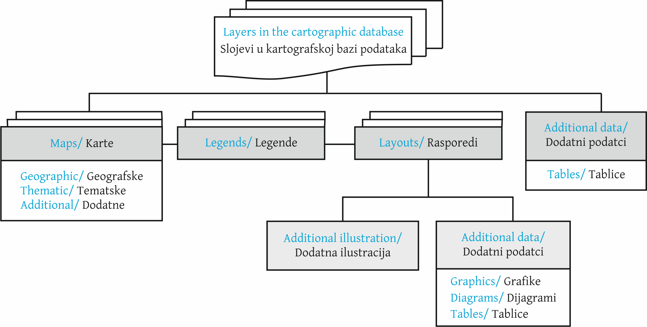
At the same time, thematic maps are created for complex atlases.
Another approach can be used to create a comprehensive atlas in MapInfo Pro GIS, as
shown in Figure 4.
Fig. 4 Organization of the complex regional atlas structure in MapInfo Pro with the
creation of typical bases.
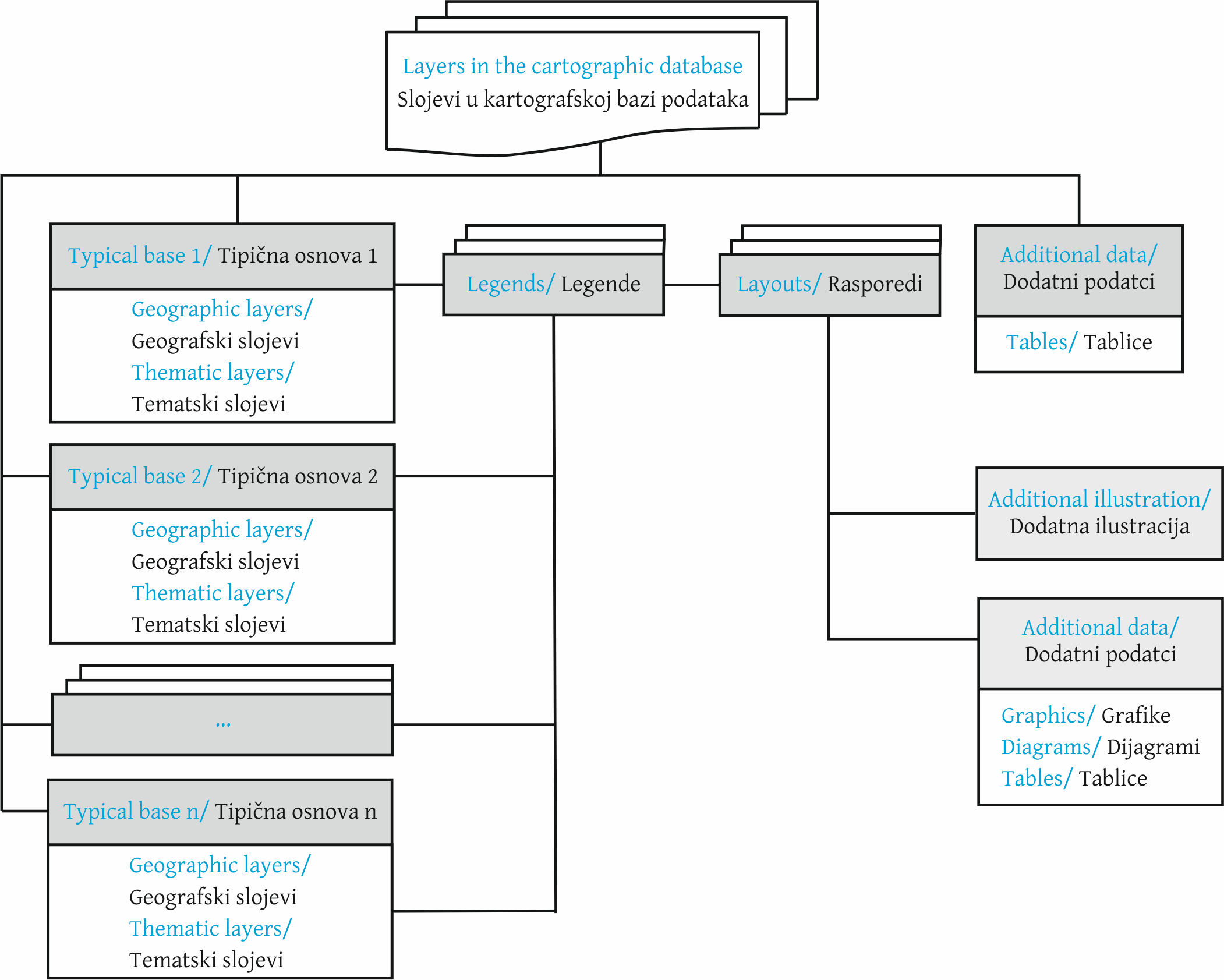
In this case, the structure of the atlas is presented by the typical geographical
bases used in the atlas, containing the main elements: boundaries, hydrography,
settlements and traffic routes. Next, the layers that make up the thematic content of
the maps are superimposed on the typical bases. The number of typical bases depends on
the scale and content of the maps (physical maps and socio-economic maps). For example,
when creating a comprehensive atlas of the Lipetsk region of the Russian Federation, the
following typical bases are formed: "Physical maps 1:1 250 000"; "Physical maps 1:1 750
000", "Socio-economic maps 1:1 250 000", "Socio-economic maps 1:1 750 000". The creation
of separate typical bases for physical maps and socio-economic maps is due to the
different composition of the geographical information displayed.
The proposed approach will reduce the number of maps in the program. However, it will
be necessary to turn on and off the thematic layers manually to display and print
different maps made on the same typical basis. Thus, it will not be possible to view
multiple thematic maps created on the same basis at the same time.
Implementation of the proposed organization of a complex regional atlas in GIS MapInfo
Pro is only made possible by writing additional modules in the MapBasic programming
language. To date, the authors have developed a software complex meant for automated
creation of the structure of the atlas and submitting the obtained structure in the form
of an additional menu, which corresponds to the projected table of contents of the
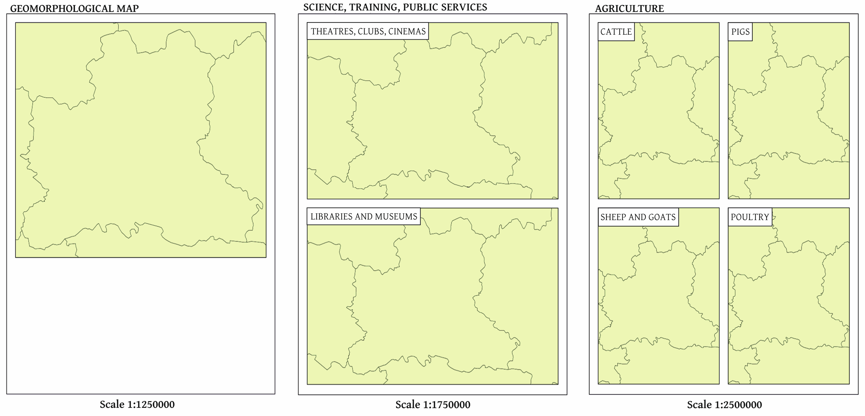
atlas. Clicking on each menu item opens a report containing the corresponding map or
maps, depending on the layout selected (Figure 5).
Fig. 5 Example of creating atlas reports in different layouts using a software package.
Conclusion
5
Despite the fairly well developed means of creating atlases in all the geographic
information systems considered, their functionality is not sufficient for the full
creation of geographical, thematic and complex regional atlases. In the article, the
authors considered the features, advantages and disadvantages of using QGIS, ArcGIS and
MapInfo Pro when creating atlases of various types, developed the basic principles of
designing the structure of the atlases in each geographic information system, and carried
out practical implementation.
As a result, two approaches to the creation of atlases in these geographic information
systems were identified:
MapInfo Pro implements a flexible map reporting system that allows each report to
be customized individually, but to combine them into a single Atlas structure,
additional functionality must be written into the MapBasic language;
in ArcGIS and QGIS, creating multipage documents involves a rigid coverage layer
(index grid) structure, which leads to a more systematic approach when designing an
atlas structure. But the rigid structure of the coverage layer leads to less
flexible design of separate atlas pages, and the imperfections of the toolkit
(especially in QGIS) require the writing of additional modules in the Python
programming language
.
The approaches and solutions formulated for improving the considered GIS allow the basic
processes for creating atlases to be automated. These proposals are of particular
practical importance in the creation of integrated regional atlases showing the situation
in the region in many areas of knowledge and used in decision-making at the regional and
municipal levels to ensure the sustainable development of territories. This is due to the
availability of a large set of available spatial and statistical data (including
population censuses and data from statistical services), allowing for the creation of a
variety of thematic maps.
For the creation of fundamental cartographic works, such as national atlases or atlases
of the world and parts of the world, a very detailed and comprehensive study involving a
large number of specialists is needed, which would entail considerable financial, human
and time resources.


