
INTRODUCTION
Today, with the advancement of technology and the widespread use of the Internet a lot of information is easily accessible to everyone with Internet access, and spatial information is one of the most important elements to support decision-making in many disciplines. Organizations around the world spend millions of dollars each year on the production and use of spatial data1, and yet there is often a problem of lack of information within organizations to perform certain tasks. To address this issue, organizations often use data from other sources and share data with each other. The large amount of spatial data that appeared in last 15 years does not facilitate their use. On the one hand, it is challenging to find and access spatial databases that are distributed through various portals of government agencies and other web portals[2]. On the other hand, there is a great redundancy of data where money and human resources are spent to collect and maintain duplicate data[3]. This has triggered the development of the Spatial Data Infrastructure (SDI) concept that solves the problem of finding spatial data and reducing their redundancy[4] and enables better data management which can achieve economic and environmental benefits. The SDI concept connects existing spatial data into a single network, and to be successfully implemented, it is necessary to harmonize and standardize existing data sets[5]. The application of this concept provides a basis for searching spatial data, their assessment and application at all social levels and facilitates integration with other data sets.
This paper provides an overview of planetary spatial data archives, data storage and retrieval methods, and their shortcomings in the context of easy search, download and interpretation of data, all with the aim of establishing SDICB that would make space data more accessible to the public and non-planetary scientists.
The first part of the paper explains planetary data and their importance and where this data can be found. The most frequently used archives and portals for access to space data are explained, and the ways of access to data as well as the main shortcomings of archives are investigated. Numerous interoperable initiatives have been launched to solve the existing problems of current ways of distributing space data. The mentioned initiatives serve as a basis for the development of the SDICB, the concept which is explained together with the future work of this research.
PLANETARY DATA
Since ancient times, mankind has always explored the stars and planets and used their observations for various applications by which they revolutionized perception and understanding of the world. With the advancement of technology, planetary science has greatly advanced, and planets have become objects of scientific research using in-situ and remote sensing methods. Our knowledge of the solar system is increasing with advances in technology and spacecraft are visiting more and more planets, satellites, comets, and asteroids. Planetary science is the science of studying planets, moons, and other space bodies in the solar system and space[8]. Many other scientific disciplines can be applied in planetary science such as geology, geography and GIS, geodesy and remote sensing, geophysics, mineralogy, volcanology, geomorphology, and others. All these disciplines are applied to determine an accurate assessment of the shape, origin, and other processes on space bodies. Scientists are working to improve our understanding of planets and other space bodies through the study of the atmosphere, surface, and their interior. The main goal of space missions is to try to understand the origin of planets and their physical processes and systems, as well as the characteristics of asteroids and other objects in space[9].
Nowadays, planetary data increasingly converges with terrestrial geo-scientific visualizations and analyzes tools. To present this data as faithfully as possible, a spatial component is needed, and today more and more space spatial data are being collected. Space spatial data are all data with a spatial component, obtained by remote sensing methods, navigation methods, georeferencing of images or collected in-situ by rovers with enough spatial information to be projected on the space body. The space spatial data stored in various archives are not easy for use by non-professional scientists, so the appropriate metadata is provided, along with different types of image data to facilitate their use for the non-planetary community[10].
The conversion of raw (unprocessed) space data into spatially enabled data involves great efforts in time and knowledge. For this to be achievable, missions must be developed and calibrated appropriately, and software and platforms for distribution of this data require continuous development and maintenance[14]. Coordinates on Earth are easily obtained from Global Navigation Satellite Systems (GNSS), system of satellites that provide autonomous geo-spatial positioning with global coverage and allow small electronic receivers to determine location on Earth, or similar positioning systems. Such sophisticated systems do not exist for planetary research. Therefore, to obtain spatial data, reference systems from astronomical observations and remote sensing of the planet`s surface (e.g., radar measurements, laser altimetry) must be realized. Cartographic maps from which the coordinates of characteristics on the planets can be easily extracted can be produced by various techniques. The most common technique is photogrammetry, and today maps are often calculated relying on the known position of grounded space missions and the known, previously derived, planetary rotation parameters.
The basic division of space spatial research data is into fundamental data, which include geodetic control networks, topographic data, and ortho-images, while the second group is framework data which include composite maps, planetary nomenclature, and geological maps. All these data have relevant information about the position in the reference coordinate system of the planet or body they are referring to. In the space archives we can find many other data, for example altimetric data for each space body, data on plasma and atmosphere of planets, orbital data, radar data, geometric shapes of planetary models and their parts, spectrometric data, etc. The most common types of data are geological data that can be found in all archives for each planet and other bodies. Geodetic and geophysical data include data on reference systems, planetary rotation and shape, topography, and gravitational models. It is also important that each data has corresponding metadata because without information on how they were taken, with which instrument and for what purpose, they would not be usable. The formats in which data is most often stored are VICAR (Video image access and retrieval) format, PDS (Planetary Data System), FITS (Flexible Image Transport System) and Raw formats such as JPEG.
For planetary data cartography, GIS, and remote sensing have an important role. Mapping of space bodies began with the invention of telescope, and with the advancement of technology, today the most important role in the mapping of space bodies has launch space missions that carry high-resolution cameras for data collection and based on this data cartographic maps are created. The biggest difference in the use of space to Earth data is the shape and size of the body being observed. International Astronomical Union (IAU) defines for all major bodies in our solar system geodetic parameters, which enables their mapping, and which are the basis for the data interoperability[12]. Maps of each planet are thematic maps, and the most common are topographic and geological maps. Nomenclature and geographical names also play an important role in data collection, and the IAU is the competent authority for planetary and satellite nomenclature[15] used to uniquely name features on the surface of space bodies so that the features can be easily found and described. Consistent and accurate nomenclature is crucial for efficient data exploitation. In addition to cartography, remote sensing is one of the most important sources of data in solar system research since it is not physically possible to visit most of the bodies. Large amounts of data are collected for each body, and GIS tools serve for conducting spatial analyzes over that collected data. Shape, topography, gravitational field, and rotation parameters are the basic characteristics of every space bodies. The part of geodesy that deals with the study of these characteristics and their influences on geophysical processes is planetary geodesy. The objectives of planetary geodesy are to establish a network of planetary geodetic control points, define reference systems, determine planetary rotation parameters, establish global and local planetary surface models, and create geographic image data, maps, and information systems[16]. Remote sensing is the most used method of data collection for planetary geodesy (radar observation, laser instruments or altimeters), but other methods, such as observing the orbital motions of satellites are also used[17]. All these methods and parameters play an important role in space science and without them it would not be possible to obtain spatially enabled data.
The innovative nature of space missions creates new technologies and study techniques that will later benefit the public on Earth and contribute to the education of future generations. Space research also contributes to the public in the form of a growing understanding of the solar system and the importance of our planet in it[8]. Space data archives have drastically changed over the years. From the storage of data for space scientist and their research, today with the increasing number of missions, archives have become of big interest for public and other (non-space) scientists.
Collection and distribution of space data face several challenges. One of them is the standardization of cartographic methods and data which is critical for accurate and precise analysis. Today, this problem is of great interest since access to data is easy and accessible to everyone. But there are still no adequate ways to store this data as well as distribute it to users. One of the main problems is extremely decentralization of space community where each organization has its own archives and data sources, but also the standards and formats they use. The solution to these problems is the development of standards that would enable the interoperability of these data between different communities and that would create the foundations for the establishment of a SDICB. Therefore, it is necessary to create spatial data that will satisfy users and that will be easy to find, share and interpret.
SPACE RESEARCH DATA ARCHIVES AND PORTALS
Space research data is archived and made available to users through data archives and portals. Access and download to all of the data is free of charge to everyone. New missions increase the number of data every year, which does not make it easier to search and access the data.
The largest archive of space research data is NASA`s Planetary Data System (PDS),https://pds.nasa.gov. PDS provides access to data and related documentation through 9 nodes. Six nodes are science discipline nodes, focusing on atmospheres, geosciences, cartography and imaging sciences, planetary plasma interactions, ring-moon systems, and small bodies. There are two support nodes: Engineering node, and the Navigation and Ancillary Information Node. The ninth node is the project management group. The primary purpose of this archive was long-term preservation of data for the space scientist`s research, so, data retrieval methods are focused on the data itself and not on the user needs. As the number of users of archived data increased and expanded to the non-planetary community over the past few years, additional data search capabilities based on various attributes are needed. These capabilities depend on the metadata quality of archived products. Although this archive is not adapted for the non-planetary community, it is the most used source of space research data today[11]. To find and download the data in the PDS, it is necessary to know the mission and the instrument of the mission that collected the data, which makes it difficult to search. Each dataset in the archive can be accessed through multiple nodes which emphasizes the redundancy of existing solutions of accessing the data. All products in the PDS are peer-reviewed, well-documented and available free of charge to scientists and the public. The data is stored in the PDS3 / 4 standard developed by NASA, and only some data can be viewed before download.
Following the PDS, the European Space Agency has created the Planetary Science Archive (PSA). PSA is an archive of data from ESA`s space missions but also distributes data from some of NASA`s missions. PSA supports and uses NASA`s PDS3 / 4 standard for archiving the data, and data is distributed through a web data browser which is based on filtering data options by type, mission, and instrument. In addition to NASA, United States Geological Survey (USGS) has the largest database of space data. USGS has developed several web searches tools. Integrated Software for Imaging and Spectrometers (ISIS) is one of USGS`s portals which consists of software for downloading, processing, and calibrating radiometric and geometric data of space research. It supports the missions of NASA, ESA, ISRO and JAXA. USGS independently creates documentation and metadata for distributed products. Map-a-Planet (Astropedia) is also under the jurisdiction of the USGS and provides to users projected images and ready-to-use products. It supports standardized WMS web mapping services for all bodies, and data search is enabled through the map view. All data can be visualized before download. On this portal it is possible to download GIS-ready products for use in standard GIS tools. According to many research and surveys, Astropedia is the most user-friendly portal and the easiest to use, especially for non-planetary users. Imaging Node Annex provides users with spatial data and products derived from PDS data (mosaics, maps, SHP files, databases). For each product the link to the original publications and information about the quality of the data is provided. Portal creates own metadata for products that are provided to users. Astrogeology USGS is a Web portal that offers users to download WMS services for more than 30 different space bodies with over 100 images. Access to WMS services of this portal is possible directly through GIS applications ArcMap, QGIS and GDAL.
These are just some of the most used portals and tools for downloading and retrieval of space research data. Numerous space missions are developing their own portals as well as national space agencies. There are also several open tools to facilitate the search of PDS and PSA, specialized portals and software for image data, and tools for data conversion or product generation from raw data formats.
But despite the fact that there are many places where data can be searched and downloaded, users, especially non-planetary users, have a general problem when searching for the data: “Where to download data and how to search for it?”. Borden and Bishop[11] in their research explored which archives and portals space scientists use the most for their research and what are their experiences using these interfaces. Once the data is archived, it becomes publicly available to users for future research. However, it is often the case that archived data is unused, so studies and initiatives are being launched to provide users with the best ways to facilitate access to data and use of data for all future potential users, under which are considered not only space but also scientists of other interests, and the public. In their research, Borden and Bishop[11] concluded that more than half of the respondents use NASA`s PDS portal to search for data or one of the search tools within the PDS science nodes, and the Geoscience node is the most used. 80 % of respondents download data, 10 % process it online using different tools before downloading it, while the rest of respondents only view the data online. More than a quarter of the respondents pointed out that the data after the download were not usable, or that the data are available in unknown formats that could not be used for further research. Some portals offer to user transformation of data before downloading to standard formats of desktop applications, and respondents believe that this example should be followed by all services. 70 % of the respondents pointed out the problem with the scale and resolution of the downloaded data, and 51 % of them think that the data were in incomprehensible coordinate systems[11].
SHORTCOMINGS OF THE ARCHIVES
The survey by Borden and Bishop[11] conducted among space scientists who frequently use archives points to many shortcomings in accessing, retrieving, and downloading space data. And what about other, non-planetary scientists and the public, what are their possibilities of finding planetary data? Space research is interdisciplinary research and not only space but also scientists of other professions are interested in it. Space exploration can give us a better understanding of our planet, so the data collected by space missions should be easily, efficiently, and understandably available to everyone. By analyzing the space data archives and portals with their services, 15 shortcomings have been identified from the perspective of non-planetary users and listed here: • dispersion of data because of existence of several access points (different data archives, within the same archive, many websites, and portals of individual missions), • data is inconsistent and incomprehensible to non-planetary scientists because metadata is not created to make it easier to understand, • data is stored in formats that cannot be used in standard processing tools and converting them into standard formats creates a risk of losing or reducing the quality of data, • related to data formats, there is a problem with their interoperability, because archives use formats that cannot be used in standard analysis and processing tools (e.g. GIS tools), • without detailed knowledge of the mission and the instruments on the mission that the data are observed, it is not possible to find data of interest. The data can only be searched with prior knowledge of which search tool to use, • archives and services are data-oriented and not user-oriented, the user interface is outdated, data search is not intuitive, and the emphasis is on long-term data storage rather than user needs. Improving archives to become more user-friendly would simplify data retrieval, • most data cannot be visualized before downloading, • searches are based on knowledge of data facts, such as knowing the mission and the instrument by which the data was collected, • no ability to search the entire archive but parts according to the specified criteria. Data retrieval services must be intuitive, • data filtering options give too much data with the same and similar descriptions and labels, which leads to the problem of choosing usable data for certain purposes, • supporting documentation is very difficult to find for some data and is often incomprehensible to non-planetary users, • instructions for using the archive are poorly distributed and abbreviated, • too much time is required to search and download data of interest, • there is no requirement that the data must be spatially located on the object which would allow more correct use of data and comparison with other data, • archives use outdated standards, especially in terms of coordinate systems and frameworks. Given the growth and large investments in space missions and technologies, these problems must be solved as soon as possible, and as one of the solutions to these problems is the establishment of SDICB.
SPACE INTEROPERABILITY INITIATIVES
The motivation to support common, interoperable data formats and standards in space research is not only to improve access to data and products but also to address the problem of distributing increasing amounts of data. Use of standards increases the reach of data, enables better visualization and analysis of data, and increases their efficiency[12]. Increase of space data has led to various initiatives in the space community that seek to increase the interoperability of data and provide easier access to data for all user groups.
Basic for spatial analysis are geodetic coordinates, and coordinate systems and frameworks which define the precise position of an object in relation to the agreed origin[18]. It is important that coordinate systems are understandable to all data users, otherwise the possibility of spatial errors increases significantly. Working Group on Cartographic Coordinates and Rotational Elements (WGCCRE) of International Astronomical Union (IAU) defines geodetic reference frameworks for all major bodies of the solar system. This includes the definition of the north, the prime meridian and the equator, and the definition of the geometric body which approximates the shape of the body and the definition of the vertical date. By adopting IAU recommendations, it is possible to exchange coordinates (spatial information) and understand spatial relationships using the same system. WGCCRE publishes every three years recommendations on coordinate systems and related parameters, which can be used to produce cartographic products of solar system bodies. The recommendations facilitate the use and comparison of multiple data sets and promote the standardized use of a set of parameters for mapping the solar system. Hare et al.[19] proposed a method to support the coordinate systems of solar system bodies within OGC standards. Within this standard, it is necessary to define a minimum set of information so that the user understands not only the data layer but also the current coordinate system and / or map projection. The EPSG (European Petroleum Survey Group) code is commonly used to define coordinate systems. If the coordinate system is not part of the EPSG database and if it is not presented with the minimum parameters for their definition, there is no simple mechanism for its explicit definition. To help address these issues within the space community, set of codes outside the EPSG has been proposed that the OGC would adopt as a standard. The proposed codes would include the definition of cartographic coordinates and rotational elements according to IAU recommendations and the numerical code of the space body defined according to the NAIF. Although these codes exist for several years, their use is still not recommended[12].
The USGS is a major provider of tools for processing and analyzing maps and other spatial data of NASA missions. The tools support Integrated Software for Imagers and Spectrometers (ISIS) and a specialized software package for image processing and processing of other space research data[20]. Although the software can load and export different formats, processing is only possible in the specialized ISIS3.cub format. Since 2007, the Geospatial Data Abstraction Library (GDAL) has added support for ISIS3 formats to improve interoperability with other applications. Current support is focused on the use of ISIS products and does not allow the development of new data. In the future, it is expected to add the possibility of developing ISIS3 data within the GDAL library[12].
Most of the data in the archives are stored in the original (raw) format of the mission instrument. For such data to be used for further analysis in GIS tools, they need to be georeferenced. Unfortunately, the PDS format is not widely recognized in GIS tools. Two formats recommended for use in space missions that are commonly used are GeoTIFF and GeoJPEG2000. GeoJPEG200 was approved by the PDS, and in 2008 it was used for the first time in Mars HiRISE mission. Another format used by the astronomical community, and whose use is also recommended for space exploration, is GeoFITS. The format is compatible with PDS standards and is supported by many open-source software tools and catalogs.
For web service interoperability, the consortium that defines standards is the Open Geospatial Consortium (OGC). Several space missions support WMS / WFS standards. This allows users to search and visualize data projected on a map in JPEG or PNG format. Of the currently published WMS/ WFS services, only some include support according to IAU recommended for coordinate systems. Also, the WMTS service is used, which enables faster delivery of map layers but is not as flexible as the previous two and cannot generate images at any scale. WCS / WCPS network services have also found application in space research[21].
IAU recommendations do not cover other standards relevant to digital mappings, such as attribute feature representations, symbols, color scales, and metadata. Digital maps must use standards so consistent cartographic products can be developed. Attributes and symbols for digital maps of space bodies are defined in the Digital Cartographic Standard for Geological Map Symbolization[22] developed by the USGS. Recommended cartographic symbols are mostly the same as for the Earth maps. The use of these standards facilitates the understanding and readability of geological or thematic maps because users are familiar with feature attributes and symbol styles[23].
Most existing space data portals often include minimal metadata and therefore have limited search capabilities for external users. The methods defined by the OGC CSW standard can facilitate user access, so users do not need to build new search tools. One of the main advantages of using the OGC CSW standard is the ability to index one data portal into another. Products served by such mutually indexed portals must provide references to data creators and source data portals. Today, more and more initiatives are encouraging the use of OGC standards in space research. Well-structured and stored metadata are extremely important for achieving interoperability. PDS metadata, in which most of space data is archived, are not supported for use on widespread spatial data portals. Most geospatial portals require metadata as defined by the FGDC or ISO. Methods for converting PDS to FGDC / ISO metadata standards should be possible, especially because FGDC metadata standards require only a few minor add-ons to properly support space data[25]. This conversion is of great importance and should be supported so that existing FGDC / ISO tools can be used for space data.
Nomenclature is also important for any cartographic product, providing context for research and analysis. The main institution for nomenclature is the IAU, which through the Gazette of the Planetary Nomenclature collects requests and publishes official nomenclature that is used in all missions. The official IAU nomenclature is publicly available for download in KML and WFS format.
Many initiatives to improve the availability of space data have been launched through volunteer communities and various private organizations. One of these initiatives is MPASIT, which provides recommendations for the development of a comprehensive planetary spatial data infrastructure. Europlanet initiative aims to connect the European space community and project of geological mapping of Mars, Mercury and the Moon was also launched within it. The VESPA initiative deals with the availability and distribution of space data from various scientific domains. Several initiatives address the standardization of space data archiving such as PlanetServer, OpenPlanetary initiative provides an online framework to help collaborate between different institutions in planetary mapping, and CARTO initiative is focused on web solutions for spatial visualization and data analysis of space research data.
SPATIAL DATA INFRASTRUCTURE OF CELESTIAL BODIES
One of the solutions to the problem of rapid increase in the amount of space research data is the establishment of an efficient SDI. The concept of SDI is widely applicable to any spatial data and is not limited to Earth data and allows data interoperability through policies and standards by defining mechanisms for data storage and access. In the paper of Laura et al., this concept applied to space data is called Planetary Spatial Data Infrastructure (PSDI)[13], 25]. Although the name PSDI describes well its purpose, and since this concept would include not only data collected on planets but data from all space objects (satellites of planets, comets, etc.), we suggest that the more correct name for this would be SDICB.
The SDICB is an extension of the traditional terrestrial SDI that will allow standardized collection, management, and retrieval of spatial data from space exploration. Today, space data is stored in archives and portals and such archives are not user-centric, do not allow semantic data search, and are adjusted for space scientists and research. The existing archives, given their objectives and method of implementation, currently do not meet the main principles of the SDI. SDI must serve the wider community whose members do not need to be spatial data experts and who do not understand the intricacies of storing, retrieving, and using spatial data. Archives are technology-oriented and need to focus on simplifying data access and improving data usability. The main reasons why SDICB is needed in the space community is that its establishment would keep all data in one place, avoid duplication of data from different agencies and space research teams, harmonize the formats of data collected and achieve their interoperability, simplify access and downloading. Using these datasets would reduce the number of difficult-to-understand data access tools and allow other users outside the space community to access and use the data. The establishment of SDICB would increase user confidence in the interoperability and accuracy of the data, which would contribute to scientific research and decision-making.
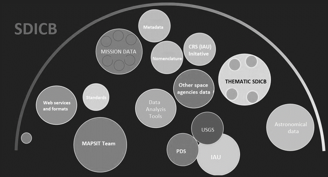
Current methods of archiving data do not allow their use by non-professional users who are not involved in the data collection. There are several initiatives within NASA and other space agencies focused on increasing the availability of space research data to the public. Most space data users are unable to process and use raw data without investing much time and effort in understanding archived data. When accessing space data, there is a big problem of decentralization of the data, given that there are many places where data can be accessed and there is a big problem of data duplication. Insufficiently clear metadata, which does not adequately describe the data and does not provide good methods for searching and filtering data of interest, is also a big problem. SDICB would centralize data by establishing a single access point for spatial data of space exploration missions. Adopting recommendations from various initiatives to improve data availability and interoperability through a unique space research metadata catalog as shown in Figure 1 would provide standardized ways of accessing data for all users, make metadata understandable to all, and would allow flexible data access technologies.
Given the great challenges and high costs associated with collecting space data, it is not surprising that the development of SDICB was not the primary problem of the space community. However, by treating and preparing the collected data as multi-purpose infrastructure products[26], this data will not remain unused, i.e., the currently inefficient management of this valuable data set will be avoided. As terrestrial SDI, SDICB would be a set of agreed standards, institutional cooperation agreements and policies to describe the framework within spatial data from space exploration will be collected and organized so that they are easily accessible and usable for a wide range of user.
As with terrestrial implementations, the SDICB concept would have 5 basic components: policy, access networks, standards, people, and data. But each of these components must be further expanded to meet space data requirements. The extension refers to answering various questions related to data and other components, and the answers to these questions provide the current state of space spatial data management and identify subjects that need to be engaged. The list of knowledge collected in this way is ideal for identifying not only the current state of the spatial data management system but also for identifying strategic gaps that should be addressed during the establishment and creation of SDICB[25,[27].
FUTURE WORK
After researching the ways of archiving space research data and their shortcomings, as well as research of various initiatives related to achieving interoperability in the space community, the SDICB concept is considered as the best solution to address these shortcomings. To define the framework for the establishment and implementation of such a concept, it is necessary to answer numerous questions and define all the elements for successful implementation. This includes establishing the definition of the SDICB with the main objectives, vision, and reasons for its establishment. The concept itself must include detailed studies on the needs and identification of users, stakeholders, and the legal basis (policies and standards) for establishment. It is necessary to solve the institutional and organizational structure (level of development and strategic plan) of the project establishment, to define the basic and thematic data, standards, and methods of collecting and storing relevant metadata. As part of the development of such a concept, a survey is currently being conducted to assess the current situation and user needs, and the results of which, along with additional research on the remaining elements of the concept, will serve in the future to establish guidelines for implementing the SDICB concept.
CONCLUSION
Today, there is a great increase in volume and art of space research data and the growing interest of scientists and the public in using this data. Data open and accessible to everyone does not make it easier to find and use it. The archives in which data are stored are intended for their long-term preservation and are focused mainly on data, not the users. To find and interpret data of interest requires too much effort and time, and searches are possible at the missions and instruments levels. Archives do not allow semantic data search, which indicates that there is a problem with insufficiently documented metadata. In addition, one of the main problems are data formats as well as their interoperability and use in standard tools. Over the past few years, several initiatives have emerged to standardize ways of collecting, storing, and distributing space research data to make them interoperable and accessible to a wide range of users. Each of these initiatives provides recommendations on how to store data and related metadata. One of the solutions to this burning problem in space community is the establishment of a SDICB that would effectively distribute data through an agreed set of standards based on recommendations, institutional cooperation agreements and policies. Successful implementation of such a concept would serve the wider community and provide an easy way to search, access and use data for all users, not just space scientists, as is the case with current ways of archiving data. This way of organizing data will allow maximum use of data and facilitate their use, especially for citizens. The scientific and research potential of archived data will increase, which will contribute to a better and easier understanding of, for example, the physics and dynamics of planets and other space bodies, and the understanding of physical and dynamic processes on Earth.