License (open-access, http://creativecommons.org/licenses/by-sa/4.0/):
CC-BY-SA
License (open-access):
Prava korištenja: CC-BY-SA
License (open-access):
Journal content is published under CC-BY-SA licence.
Publication date: 2021
Volume: 20
Issue: 36
News
Međunarodna kartografska konferencija (ICC2021)
Miljenko Lapaine
; Geodetski fakultet Sveučilišta u Zagrebu Kačićeva 26, Zagrebr
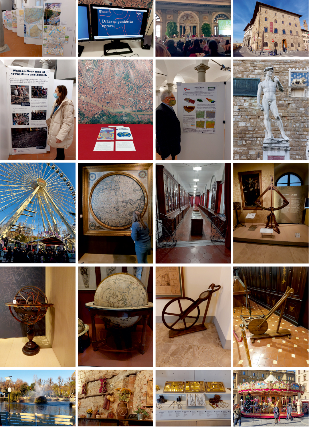
Međunarodna kartografska konferencija održana je od 14. do 18. prosinca 2021. u Firenci (https:// www.icc2021.net). Konferencija je bila planirana za mjesec srpanj, jer se takve konferencije tradicionalno održavaju ljeti. Međutim, odgođena je zbog pandemije i održana u hibridnom obliku. Osim osobnog sudjelovanja, bilo je omogućeno i sudjelovanje online.
273798
21.1.2022.
![]()
Visits: 1.705 *
Florence, 14−18 December 2021
The International Cartographic Conference was held from 14 to 18 December 2021 in Florence (https://www.icc2021.net). The conference was planned for July, as such conferences are traditionally held in the summer. However, it was postponed due to the pandemic and maintained in a hybrid form. In addition to personal participation, online participation was also possible. This is official data (https://icaci.org/icc2021/):
630 participants from 53 countries, whereof 49% in person
Papers: 563 presentations, 80 sessions
2 keynote speeches + 4 special sessions
International Map Exhibition: 410 maps and related objects from 32 ICA members
International Children’s Map Competition: 178 maps from 32 countries
210 participants for the Opening Reception
100 participants for the Gala Dinner
27 scholarships for young researchers
Abstracts and full papers presented at the conference were published in the International Journal of Cartography, the book Advances in Cartography and GIScience of the ICA, the Proceedings of the ICA and the book of Abstracts of the ICA (https://www.ica-conference-publications.net/).
All previous international cartographic conferences have been held in one or two places in the chosen city, usually in a large congress centre. The conference in Florence was significantly different from other conferences because the events took place in five different locations. The opening ceremony was at the Salone Dei Cinquecento Palazzo Vechio, Plazza della Signoria. Lectures and presentations were held at the Faculty of Humanities, University of Florence, Via Laura 48. The international cartographic exhibition was at the Military Geographical Institute in Via Cesare Battisti 10, the exhibition of children's art works at the Ex-Circolo Palazzo Medici Riccardi in Via de Ginori 14, and the closing ceremony at the Pegaso Hall, Palazzo Guadagni Strozzi Sacrati at Piazza Duomo 10. Add to that the meeting of the ICA Executive Board with the chairs of the commissions in Aula La Sapienza, Via San Gallo 10. All these spaces are beautiful palaces rich in decorations that leave a special impression. However, old buildings often have some downsides. E.g. Aula La Sapienza is a huge hall with very poor acoustics. If I add to this the lack of heating, then it is clear that attending a session in such a space was not at all a pleasant experience.
Even sadder and in fact incomprehensibly poorly organized was the opening ceremony at the Salon Dei Cinquecento in Palazzo Vecchio in Florence. The opening ceremony programme was planned and lasted for about four hours! It seems that all the dignitaries had to say something. And it was always the same thing, that cartography is important and that Florence and Tuscany are beautiful. The huge space could not be heated by several heaters placed along the walls. When the speeches were finally over, the organizers asked us to wait because the young musicians had not yet arrived! And when the concert was over, there was a break again because the reception did not arrive on time! I have attended 17 international cartographic conference opening ceremonies (since 1989 in Budapest), and I have never experienced something as disastrous as this.
The university venue made it possible for everyone to experience the scientific programme, while those in person had the added benefit of events that highlighted the beautiful art, history, and architecture of the Renaissance City. Most colleagues who attended in person came from Europe. Other regions were represented by Chile, the United Arab Emirates, and the United States.
As part of international cartographic conferences, an international map exhibition and an exhibition of children's drawings are traditionally held. This year, 26 chilren’s art works were submitted to the competition A map of my future world, which was conducted by the Croatian Cartographic Society. A special committee selected six children's works for the international exhibition in Florence. A detailed presentation with the results of the competition can be found in an article in this issue of the journal.
The following maps and related products from Croatia have been registered and exhibited at the international map exhibition:
Cartography in GeoTwinn, Croatian Geological Survey
Glina town walk-on floor map, State Geodetic Administration
Zagreb town walk-on floor map, State Geodetic Administration
GeoHrvatska – Spatial Data of the Republic of Croatia, State Geodetic Administration
Cartography and Geoinformation, Vol. 19, No. 34, Croatian Cartographic Society
Cartography and Geoinformation, Vol. 19, No. 35, Croatian Cartographic Society
During the Closing Ceremony, Paola Zamperlin and Margherita Azzari offered summary details of the conference. This was followed by a series of ICA awards, the results of the International Cartographic Exhibition and recognition of ICA scholarship awardees, all of which will be shared in a subsequent blog. Professor Giuseppe Scanu, President of the Italian Cartographic Society, offered a note of thanks to the Local Organizing Committee and supporters of the ICC.
At the ICA Awards Ceremony the following awards were presented in recognition of contributions to the ICA and outstanding contributions to the field and science of cartography:
Ulrich Freitag from Germany and Alan MacEachran from the USA received the Carl Mannerfeld Gold Medal
Georg Gartner from Austria, Lyandros Tsoulos from Greece and Vladimir Tikunov from Russian received the ICA Honorary Fellowship
Paola Zamperlin, Marghertia Azzari and Gilberto Fumarola from Italy, and Manuela Schmidt from Austria received the Diploma for outstanding services to ICA.
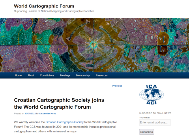
The World Cartographic Forum was founded in 2017 as a body within the International Cartographic Association to encourage national cartographic/mapping societies to discuss issues such as membership retention and organisational change, to share expertise and good practice, and to build international links between societies (http://wcf.icaci.org). The Forum supports the ICA’s mission to promote the disciplines and professions of cartography and GIScience in an international context, specifically through the conduit provided by national cartographic and mapping societies. Membership to the Forum is open to any broadly national cartographic/mapping society. At the meeting held in Florence, the Croatian Cartographic Society joined the World Cartographic Forum (https://wcf.icaci.org/2022/01/10/croatian-cartographic-society-joins-the-world-cartographic-forum/).
One of the events that accompany every international conference are organized visits to important cultural and historical institutions. In Florence, it was a tour of the Galileo Museum, a visit to the Italian Geographic Military Institute, an exhibition of Natura Collecta and a visit to Dante's cosmography at the Pitti Palace. Due to the diverse programme, I was able to visit only the Galileo Museum and the Military Geographical Institute.
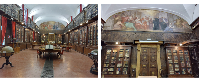
Museo Galileo, the former Istituto e Museo di Storia della Scienza is located in Florence, in Piazza dei Giudici, along the River Arno and close to the Uffizi Gallery. The museum, dedicated to astronomer and scientist Galileo Galilei, is housed in Palazzo Castellani, an 11th-century building which was then known as the Castello d’Altafronte. Museo Galileo owns one of the world's major collection of scientific instruments, which bears evidence to the role that the Medici and Lorraine Grand Dukes attached to science and scientists.
In 1929, the First Italian Exhibition of the History of Science in Florence highlighted the importance of scientific collections within Italy's cultural heritage. As a consequence, in 1930 the University of Florence gave birth to the Istituto di Storia della Scienza con annesso Museo (Institute of the History of Science and attached Museum). The Institute was housed in Palazzo Castellani and was entrusted with the instrument collections of the Medici and Lorraine dynasties. The permanent exhibition is arranged according to chronological and thematic paths.
The Museum of the History of Italian Cartography is housed in the Italian Military Geographical Institute (Istituto Geografico Militare − IGM) in Florence (https://www.igmi.org/). The IGM is the Army’s geographic supporting office, and it is employed by the Comando alla Capitale. It is also the National Cartographic Authority according to Law no. 68/1960 and therefore the high-quality cartography, produced by the institute and used by both public and private entities, is considered the official state cartography. In 1861, after the Italian unification, the IGM began its activity as the Topographic Office of the Italian Army Staff, inheriting traditions and experiences from the topographic offices of three pre-Unitarian states: the Kingdom of the Two Sicilies, the Kingdom of Sardinia and, of course, the Grand-Duchy of Tuscany. It was moved from Turin to Florence in 1865, it became the military topographic office in 1872 and ten years later it was named the Italian Geographic Institute.
IGM’s main activities are:
Production, updating and sale of medium and small-scale cartography;
High-resolution photogrammetric measurement of Italy;
Set up and management of a geographic database;
Maintenance, measurement and benchmarking of the state borders;
Conservation of National cartography.
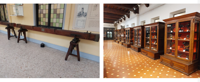
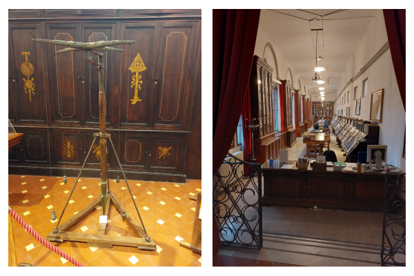
The IGM Museum of Instruments, as part of the Historical Museum of Italian Cartography, hosts a valuable collection of the instruments used to carry out works of astronomy, geodesy, topography, photogrammetry and calculation. There are more than 400 instruments; the ancient ones were part of the collection existing before 1861 and belonged to the dissolved topographic offices of the pre-existing Italian States. When IGM was established, the collection was expanded to include instruments designed and built by internal staff. Even today, all the instruments used for carrying out IGM activities become part of the museum when obsolete.
The IGM Library currently holds the following:
About 120 000 books covering Geography, Geodesy, Cartography, Topography, Astronomy, the History of Cartography, Explorations and Discoveries, Anthropology, Ethnography, City Planning, Regional Planning, Remote Sensing, Information Technology, GIS – Geographic Information System, etc... and publications of general interest and related to the military field (history, politics, economics, etc...);
A collection of nearly 700 geographic atlases, the oldest one dating back to 1570;
A map collection of ancient and modern maps, the majority of the latter have been acquired through exchanges with other cartographic societies around the world;
A journal section collecting 750 national and international journals acquired by the Institute through an exchange partnership with other institutes and organisations: “L’Universo” and the “Bollettino di geodesia e scienza affini”. The “Bollettino di geodesia e scienza affini” is no longer issued but features in the Universo magazine.
A collection of photographs, the oldest dating back to 1865.
Visits to the Galileo Museum and the Military Geographical Institute left a deep impression on me. It is really a must see and I recommend it to anyone who takes a trip to Florence.
At the end of this travel report just a few words about a few experiences. Although people travel on a significantly reduced scale due to the pandemic, and although Lufthansa is a reputable airline, my luggage was lost. It was not so much a problem in personal matters as in the exhibits for the exhibition (two copies of the journal Cartography and Geoinformation). When I told my colleagues in Zagreb what happened, we managed to quickly agree that our colleague Iva Cibilić, who had not yet set off for Florence, would take two journals with her. Thanks to her, the journals arrived on time for the opening of the exhibition. Not only that, but colleague Iva also helped with the installation of other exhibits on the billboards, so I would like to thank her especially for that.
Coincidentally, my two presentations were scheduled according to the programme of the last day of the conference in two different halls. Noticing that the programme was not ideal for that day, there was a break of an hour and a half introduced (?!), I recorded my lectures in advance, just in case, and sent them to the organizers. This proved to be good, because the organizers changed the schedule at the last minute without informing the lecturers (?!). In the end, my presentations ended happily, but the organizational confusion is difficult to understand and accept.
It was not possible for colleagues from South Africa to travel to Italy but that did not dampen their excitement for inviting all of us to Cape Town in 2023 for the 31st International Cartographic Conference and the 19th General Assembly. The South Africa Committee offered a video enticing us to come along to Cape Town which was supplemented with a detailed presentation on what to expect and key dates to note which are now live on the ICC2023 website (https://icc2023.org/).
Firenza, 14-18. prosinca 2021.
Međunarodna kartografska konferencija održana je od 14. do 18. prosinca 2021. u Firenci (https://www.icc2021.net). Konferencija je bila planirana za mjesec srpanj, jer se takve konferencije tradicionalno održavaju ljeti. Međutim, odgođena je zbog pandemije i održana u hibridnom obliku. Osim osobnog sudjelovanja, bilo je omogućeno i sudjelovanje online. Ovo su službeni podatci (https://icaci.org/icc2021/):
630 sudionika iz 53 zemlje, od čega 49% osobno
članci: 563 prezentacije, 80 sjednica
2 pozvana predavanja + 4 posebne sjednice
Međunaordna izložba karata: 410 karata i srodnih proizvoda iz 32 zemlje članice ICA-e
Međunaordno natjecanje dječjih karata: 178 karata iz 32 zemlje
210 sudionika na domjenku otvaranja
100 sudionika na svečanoj večeri
27 stipendija mladim istraživačima
Sažetci i cjeloviti radovi izloženi na konferenciji objavljeni su u časopisu International Journal of Cartography, knjizi Advances in Cartography and GIScience of the ICA, zborniku Proceedings of the ICA i knjizi sažetaka Abstracts of the ICA (https://www.ica-conference-publications.net/).
Sve dosadašnje međunarodne kartografske konferencije održavale su se na jednom ili dva mjesta u odabranom gradu, obično u nekom velikom kongresnom centru. Konferencija u Firenci bitno se razlikovala od ostalih konferencija jer su se događanja odvijala na pet različitih lokacija. Svečano otvaranje bilo je u Salone Dei Cinquecento Palazzo Vechio, Palzza della Signoria. Predavanja i prezentacije održavani su na Fakultetu humanističkih znanosti Sveučilišta u Firenci, Via Laura 48. Međunarodna kartografska izložba bila je u Vojno-geografskom institutu u Via Cesare Battisti 10, izložba dječjih likovnih radova u Ex-Circolo Palazzo Medici Riccardi u Via de Ginori 14, a svečano zatvaranje u Sali Pegaso, Palazzo Guadagni Strozzi Sacrati na Piazza Duomo 10. Dodajmo k tome još i sjednicu Izvršnog odbora ICA-e s predsjedavajućima povjerenstava u Auli La Sapienza, Via San Gallo 10. Sve su to lijepe palače bogate dekoracijama koje ostavljaju poseban dojam. Međutim, stara zdanja često imaju i neke negativne strane. Npr. Aula La Sapienza je ogromna dvorana s vrlo slabom akustikom. Ako k tome još dodama nedostatak grijanja, onda je jasno da sudjelovanje na sjednici u takvom prostoru nije bio nimalo ugodan doživljaj.
Još tužnije i zapravo neshvatljivo loše organizirano bilo je svečano otvaranje konferencije u Salonu Dei Cinquecento u Palazzo Vechio u Firenci. Program svečanog otvaranja bio je planiran, a i trajao je oko četiri sata! Izgleda da su svi uglednici morali nešto reći. A to je uvijek bilo jedno te isto, da je kartografija važna i da su Firenca i Toskana lijepe. Ogroman prostor nije moglo ugrijati nekoliko grijalica postavljenih uz zidove. Kad su govorancije konačno bile gotove, organizatori su zamolili da pričekamo jer mladi glazbenici još nisu stigli! A kad je koncert bio gotov, opet je bila stanka jer domjenak nije stigao na vrijeme! Bio sam na 17 svečanih otvaranja međunarodnih kartografskih konferencija (od 1989. u Budimpešti), a ovako nešto katastrofalno još nisam doživio.
Sveučilišni prostor omogućio je svima da dožive znanstveni dio programa, dok su svi oni koji su doputovali imali dodatnu korist od događanja koja su istaknula prekrasnu umjetnost, povijest i arhitekturu renesansnog grada. Većina kolega došla je iz Europe. Od ostalih zemalja spomenimo Čile, Ujedinjene Arapske Emirate i Sjedinjene Američke Države.
U sklopu međunarodnih kartografskih konferencija tradicionalno se održavaju međunarodna izložba karata i izložba dječjih likovnih radova. Na natječaj za dječje likovne radove „Karta mojega budućega svijeta“ (A map of my future world) koji je u Hrvatskoj provelo Hrvatsko kartografsko društvo stiglo je ove godine 26 radova. Posebno povjerenstvo odabralo je 6 dječjih radova za međunarodnu izložbu u Firenci. Detaljan prikaz s rezultatima natječaja nalazi se u posebnom članku u ovom broju časopisa.
Za međunarodnu izložbu karata prijavljene su i izložene ove karte i njima srodni proizvodi iz Hrvatske:
Cartography in GeoTwinn, Hrvatski geološki institut
Glina town walk-on floor map, Državna geodetska uprava
Zagreb town walk-on floor map, Državna geodetska uprava
GeoHrvatska – Spatial Data of the Republic of Croatia, Državna geodetska uprava
Cartography and Geoinformation, Vol. 19, No. 34, Hrvatsko kartografsko društvo
Cartography and Geoinformation, Vol. 19, No. 35, Hrvatsko kartografsko društvo
Tijekom ceremonije zatvaranja, Paola Zamperlin i Margherita Azzari prikazale su sažeto detalje konferencije. Slijedilo je uručivanje nagrada, rezultati Međunarodne kartografske izložbe i dodjela priznanja dobitnicima stipendija ICA-e. Profesor Giuseppe Scanu, predsjednik Talijanskoga kartografskog društva, zahvalio je Lokalnom organizacijskom odboru i svima koji su podržali ICC2021. Na ceremoniji dodjele nagrada dodijeljene su sljedeće nagrade kao priznanje za doprinos ICA-i i izuzetan doprinos području i znanosti kartografije:
Ulrich Freitag iz Njmečke i Alan MacEachran iz SAD-a dobili su zlatnu medalju Carla Mannerfelda
Georg Gartner iz Austrije, Lyandros Tsoulos izu Grčke i Vladimir Tikunov iz Rusije dobili su počasno članstvo (ICA Honorary Fellowship)
Paola Zamperlin, Marghertia Azzari i Gilberto Fumarola iz Italije te Manuela Schmidt iz Austrije dobili su diplomu za izuzetne zasluge ICA-i.
Svjetski kartografski forum (World Cartographic Forum) osnovan je 2017. godine kao tijelo unutar Međunarodnog kartografskog društva kako bi se potaknula nacionalna kartografska društva da raspravljaju o pitanjima kao što su zadržavanje članstva i organizacijske promjene, da dijele stručnost i dobru praksu te da izgrade međunarodne veze među društvima (http://wcf.icaci.org). Forum podržava misiju ICA-e da promovira discipline i profesije kartografije i GIS-znanosti u međunarodnom kontekstu, posebno kroz kanale koje pružaju nacionalna kartografska društva. Članstvo u Forumu otvoreno je za bilo koje nacionalno kartografsko društvo. Na sastanku održanom u Firenci Hrvatsko kartografsko društvo pristupilo je Svjetskom kartografskom forumu (https://wcf.icaci.org/2022/01/10/croatian-cartographic-society-joins-the-world-cartographic-forum/).
Jedan od nezaobilaznih događaja koji prate svaku međunaordnu konferenciju su organizirani posjeti važnim kulturno-povijesnim institucijama. U Firenci to je bio obilazak Galilejeva muzeja, posjet Talijanskom vojno-geografskom institutu (Italian Geographic Military Institute – IGMI), izložba Natura Collecta i posjet Danteovoj kozmografiji u palači Pitti. Zbog raznolikog programa uspio sam posjetiti samo Galilejev muzej i Vojno-geografski institut.
Galilejev muzej, bivši Istituto e Museo di Storia della Scienza, nalazi se u Firenci, na Piazza dei Giudici, uz rijeku Arno i blizu galerije Uffizi. Muzej, posvećen astronomu i znanstveniku Galileu Galileiju, smješten je u palači Castellani, zgradi iz 11. stoljeća. Galilejev muzej posjeduje jednu od najvećih svjetskih zbrki znanstvenih instrumenata, koja svjedoči o ulozi koju su veliki knezovi Medici i Lorraine pridavali znanosti i znanstvenicima.
Godine 1929., prva talijanska izložba povijesti znanosti u Firenci istaknula je važnost znanstvenih zbirki unutar talijanske kulturne baštine. Kao posljedica toga, sveučilište u Firenci je 1930. godine osnovalo Istituto di Storia della Scienza con annesso Museo (Institut za povijest znanosti i pridruženi muzej). Stalni postav muzeja poštuje kronološki i tematski pristup.
Muzej povijesti talijanske kartografije smješten je u Talijanskom vojno-geografskom institutu (Istituto Geografico Militare − IGM) u Firenci (https://www.igmi.org/). IGM je geografski pomoćni ured vojske. To je također Nacionalna kartografska uprava prema zakonu br. 68/1960 i stoga se visokokvalitetna kartografija, koju proizvodi institut i koriste i javna i privatna tijela, smatra službenom državnom kartografijom. Godine 1861., nakon ujedinjenja Italije, IGM je započeo svoju djelatnost kao Topografski ured stožera talijanske vojske, nasljeđujući tradiciju i iskustva topografskih ureda triju država: Kraljevine dviju Sicilija, Kraljevine Sardinije i, naravno, Velikoga Vojvodstva Toskane. Premješten je iz Torina u Firencu 1865., postao je vojni topografski ured 1872., a deset godina kasnije dobio je ime Talijanski geografski institut.
Glavne aktivnosti IGM-a su:
Proizvodnja, ažuriranje i prodaja karata u srednjim i sitnim mjerilima
Fotogrametrijska izmjera Italije u visokoj razlučivosti
Postavljanje i upravljanje geografskom bazom podataka
Održavanje, mjerenje i određivanje državnih granica
Očuvanje nacionalne kartografije.
Muzej instrumenata IGM-a, kao dio Povijesnog muzeja talijanske kartografije, čuva vrijednu zbirku instrumenata koji su se upotrebljavali za izvođenje radova iz astronomije, geodezije, topografije, fotogrametrije i računanja. Instrumenta ima više od 400, a stari su bili dio zbirke koja je postojala prije 1861. i pripadala raspuštenim topografskim uredima već prethodnih talijanskih država. Kada je IGM osnovan, zbirka je proširena na instrumente koje je dizajniralo i izradilo interno osoblje. I danas su svi instrumenti koji su se upotrebljavali za obavljanje aktivnosti IGM-a dio muzeja, premda su zastarjeli.
U knjižnici IGM-a trenutno se nalaze:
Oko 120 000 knjiga koje pokrivaju područja geografije, geodezije, kartografije, topografije, astronomije, povijesti kartografije, istraživanja i otkrića, antropologije, etnografije, urbanizma, regionalnog planiranja, daljinskog istraživanja, informacijske tehnologije, GIS-a itd. i publikacije od općeg interesa i vezane uz vojnu oblast (povijest, politika, ekonomija, itd...)
Zbirka od gotovo 700 geografskih atlasa, od kojih najstariji datira iz 1570. godine
Zbirka karata starih i suvremenih karata, većina potonjih nabavljena je razmjenom s drugim kartografskim društvima diljem svijeta
Odjel časopisa koji prikuplja 750 domaćih i međunarodnih časopisa koje je Institut nabavio partnerstvom s drugim institutima i organizacijama: “L’Universo” i “Bollettino di geodesia e scienza affini”. “Bollettino di geodesia e scienza affini” više ne izlazi.
Zbirka fotografija, od kojih najstarija datira iz 1865. godine.
Posjeti Galilejevu muzeju i Vojno-geografskom institutu ostavili na mene dubok dojam. To je nešto što se zaista mora vidjeti i preporučam svima koje put navede u Firencu.
Na kraju ovog izvještaja s putovanja još samo par riječi o nekoliko doživljaja. Premda zbog pandemije ljudi putuju u bitno smanjenom opsegu i premda je Lufthansa renomirani avioprijevoznik, ipak se moja prtljaga putem izgubila. Nije bio toliko problem u osobnim stvarima, koliko u izlošcima za izložbu (dva primjerka časopisa Kartografija i geoinformacije). Kad sam to javio kolegama u Zagrebu, uspjeli smo se na brzinu dogovoriti da takva dva časopisa ponese sa sobom kolegica Iva Cibilić, koja još nije bila krenula na put u Firencu. Zahvaljujući njoj, časopisi su na vrijeme stigli na otvorenje izložbe. Ne samo to, kolegica Iva je pomogla pri postavljanju i ostalih izložaka na panoe, pa joj ovim putem na tome posebno zahvaljujem.
Stjecajem okolnosti, moja dva izlaganja bila su predviđena po pogramu zadnjega dana konferencije u dvije različite dvorane. Uočivši da za taj dan program nije sastavljen idealno, stanka od sat i pol (?!), svoja predavanja sam, za svaki slučaj, unaprijed snimio i poslao organizatorima. To se pokazalo dobrim, jer su organizatori u zadnji čas promijenili raspored, a da o tome nisu obavijestili predavače (?!). Na kraju su moji nastupi sretno završili, ali učinjenu organizacijsku zbrku teško se može razumijeti i prihvatiti.
Kolegama iz Južne Afrike nije bilo moguće doputovati u Italiju, ali to nije umanjilo njihovo uzbuđenje što su nas sve pozvali u Cape Town 2023. na 31. međunarodnu kartografsku konferenciju i 19. generalnu skupštinu. Južnoafrički odbor pripremio je video koji nas je mamio da dođemo u Cape Town dopunjen detaljnom prezentacijom o tome što očekivati i ključnim datumima koje treba zabilježiti, a koji su sada uživo na web stranici sljedeće konferencije ICC2023 (https://icc2023.org/).