License (open-access, http://creativecommons.org/licenses/by-sa/4.0/):
CC-BY-SA
License (open-access):
Prava korištenja: CC-BY-SA
License (open-access):
Journal content is published under CC-BY-SA licence.
Publication date: 2021
Volume: 20
Issue: 36
News
Donacija knjiga i atlasa gospođe Zlate Novak iz ostavštine dr. Drage Novaka
Miljenko Lapaine
273803
21.1.2022.
![]()
Visits: 1.776 *
Dr. Drago Novak (1933 - 2011) was a radiologist, traveller and lover of old maps. He completed his medical studies in Zagreb, specializing in radiology. He worked at the University Clinics in Munich and Hamburg. He was the director of the Central Institute of Radiology of the Clinic in Ludwigshafen, and then the director of the Janker Clinic in Bonn. From 1984 to 2001 he worked at his own Institute for X-ray Diagnostics and Nuclear Medicine in Bonn.
Drago Novak especially appreciated and collected works by contemporary Croatian artists, and he was especially fond of painting. He also collected a very rich library, covering various areas of his interest, including professional works in medicine and cartography, monographs on art history and fiction or children's literature. Copies of his books are equipped with Ex Libris made by some of the most renowned Croatian and foreign artists, and they were also part of the great collecting passion of Drago Novak. He was a member of many scientific associations. During the Homeland War, he participated in collecting material aid abroad, as well as in promoting Croatia. He was a member of the World Association of Croatian Physicians (WACP) and the initiator, founder and first Secretary General of the World Croatian Congress, the umbrella association of the Croatian Diaspora.
In addition, Drago Novak was a passionate lover of old maps and a collector of maps, nautical charts and isolarios of the Adriatic and panoramas of Croatian cities. Very early on, while the old maps of Croatian lands were of interest to few in collectors' circles, he acquired the first map and thus founded the Novak Collection. Through his last wish, a rich collection of maps, atlases and books in the field of the history of cartography, known as the Novak Collection, became part of the Collection of Geographical Maps and Atlases of the National and University Library in Zagreb. The Novak - Mappae Croaticae Collection is one of the few, most important and richest Croatian cartographic collections. Through many years of dedicated work and diligence, Drago Novak collected a cartographic collection of 570 map sheets, 63 volumes of atlases with accompanying Ex Libris Novak and 99 volumes of books, also with accompanying Ex Libris. During his life he often visited the National and University Library in Zagreb and expressed the wish that after his death the Novak Collection be stored and processed in the Collection of Geographical Maps and Atlases as a complete, digitized unit, published as a catalogue and that users and the general public be provided access to this unique valuable Croatian cartographic cultural heritage.
In 2005, an extensive publication Pet stoljeća geografskih i pomorskih karata Hrvatske (Five Centuries of Geographical Maps and Charts of Croatia) was published, co-authored by Drago Novak and illustrated mostly with maps from the Collection. This book was created through several months of joint work by Drago Novak, Dubravka Mlinarić and me in the afternoons in my room at the Faculty of Geodesy in Zagreb. Drago Novak was its initiator and spiritus movens, while his wife Zlata was an unusually patient logistical support for the entire project.
In 2018, the book Zbirka Novak - Mappae Croaticae u Zbirci zemljovida i atlasa NSK (The Novak Collectoin - Mappae Croaticae in the Collection of Maps and Atlases of the National and University Library) was published. The book consists of two main parts. The first part discusses the history of Croatian cartography and its influence on the creation of the Novak Collection. The second part of the book contains a catalogue of selected maps with illustrations and descriptions and a list of the entire cartographic material of the Novak Collection in the National and University Library in Zagreb.
In 2021, Mrs. Zlata Novak offered the Croatian Cartographic Society a part of the rich library from Drago Novak's legacy related to cartography: books and atlases. Since the Croatian Cartographic Society did not have adequate space, this donation was taken over by the Faculty of Geodesy, University of Zagreb. As a token of gratitude, the Croatian Cartographic Society, at its annual assembly held on 7 December 2021, awarded Mrs. Zlata Novak a Certificate of Appreciation for the donation of valuable books and atlases from the legacy of Dr. Drago Novak to the Faculty of Geodesy, University of Zagreb.
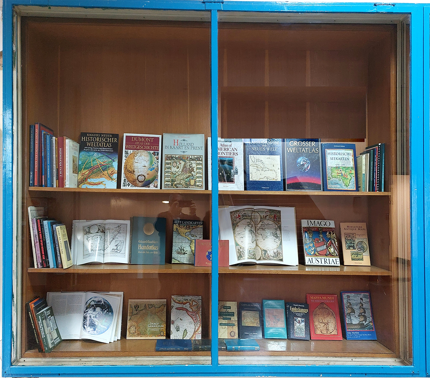
The following is a list of the donated books and atlases. Each book has the signature of D. Novak, the date and place of purchase of the book and his Ex Libris.
Albertina-Wien, Zeichnungen 1450-1950, Kunsthalle, 1986
Berthon S, Robinson A: The Shape of the World, IBM, Georg Philip Ltd., London, 1991
Boorstin D J: Entdeckungen, Das Abenteuer des Menschen, sich und die Welt zu erkennen, Pawlak, 1985
Deák A A: A Duna Fölfedezése, Vizügyi Múzeum, 2004
Gróf L: Carta Hungarica, InterPress, Budapest, 1988
Harvey P D A: Mappa Mundi, The Hereford World Map, Herefors Cathedral, The British Library, 1996
Holzamer K: Von Danzig bis Riga, Germanisches Nationalmuseum, 1982
Humphreys A L: Antique Maps and Charts, Bracken Books, London, 1989
Imago Germaniae, Das Deutschlandbild der Kartenmacher in funf Jahrhundeten, Staatsbibliothek zu Berlin, Anton H. Konrad Verlag, 1996
Jolly D C: Antique Maps / Sea Charts / City Views / Celestial Charts & Battle Plans, Price Guide and Collectors' Handbook for 1983, Brookline, 1983
King G: Miniature Antique Maps, Map Collector Publications. 1996
Kisari Balla G: Manó Kogutowicz: The great Hungarian cartographer, Budapest 1997
Kish G: La carte / image des civilisations, Seuil, Paris, 1980
Kohl J G: Progress of Discovery, Auf den Spuren der Entdecker, ADEVA, Graz, 1993
Kunisch J: Prinz Eugen von Savoyen und Seine Zeit, Ploetz-Biographie, Verlag Ploetz Freiburg, 1986
Kupčik I: Alte Landkarten, Dausien, 1980
La Ronicere M de, Jourdin M M du: Portulane, Seekarten vom 13. bis zum 17. Jahrhundert, Hirmer Verlag München
Landkarten - Stadtansichten Dekorative Graphik, Auktion 20/II, Buch- und Kunstauktionshaus F. Zisska & R. Kistner, 1992
Maps of the Past Diary 2003, The British Library, 2002
Meurer P H: Fontes Cartographici Orteliani, VCH, Acta humaniora, 1991
Miller K: Weltkarte des Arabers Idrisi vom Jahre 1154. Brockhaus Antiquarium Stuttgart, 1981
Norwich O I: Norwich's Maps of Africa, Terra Nova Press, 1997
Pagani L: Kartographie der Neuen Welt, Parkland, 1992
Phillips' Maps and Atlases of the WWI Period. Reprint, 1995
Resende M T: Cartografia Impressa dos Séculos XVI e XVII / Images de Portugal e Ilhas Atlânticas, Porto, 1994
Riđanović J: Geografija mora, Hrvatski zemljopis, Zagreb, 2002
Rothaug R: Geographischer Atlas zur Vaterlandskunde an den österreichischen Mittelschulen, Freytag & Berndt, Wien, 1911
Schulmeister O: Imago Austriae, Verlag Herder Wien, 1979
Schwarze W: Atlas Maritime / See-Atlas "Le Neptune Françoys" des Pierre Mortier, Kunst und WohnenVerlag, Wuppertal, 1977
Seifert T: Die Karte als Kunstwerk, Bayerische Staatsbibliothek, 1979
Shapero B: Cartography, A selection from stock
Shepard's International Directory of Ephemera Dealers, Richard Joseph, 1994
Shepard's International Directory of Print and Map Sellers, 1995
Taliafero H G: Cartographic Spurces in the Rosenberg Library, Texas A&M University Press, 1988
The Discovery of the World, Maps of the Earth and the Cosmos, From the David M. Steward Collection, University of Chicago Press, 1985
The World Encompassed, an exhibition of the history of maps held at the Baltimore Museum of Art, Published by the Trusteed of the Walters Art Gallery, Baltimore, Maryland, 1952
Thrower N J W: Maps & Civilization, The University of Chicago Press, 1996, 1999
Unsere Erde, Ein Weltatlas herausgegeben vom Geberal-Anzeiger der Stadt Wupertal, Verlag W. Girardet
Van Ermen E: The United States in Old Maps and Prints, Atomium Books, 1990
Walter A: A Portolan Atlas of the Mediterranean Sea and Western European Waters (with a World Map), attributed to Juan Oliva, Washington, 1987
Whitfield P: The Image of the World, The British Library, 1994
Wigal D: Historische Seekarten, 1290-1699, Parkstone Press, NY, USA, 2000
Wuttke H: Ueber Erdkunde und Karten des Mittelalters, Leipzig, 1853
Young P: Der Grosse Atlas zum II. Weltkrieg, Bechtermünz Verlag, 1974
Zögner L: Die Welt in Händen, Staatsbibliothek Berlin, 1989
Allen Ph: Atlas der Altassen, Hes, Brepols, 1992
Black J: Dumont Atlas der Weltgeschichte, Dumont, 2000
Boomgaard J E A: Holland in Kaart en Prent, Fibula-Van Dishoeck, 1984
Burton R, Cavendish R, Stonehouse B: Atlas der grosen Entdecker, The Automobile Association, 1992
Eduard Gaeblers Handatlas über alle Teile der Erde, Georg Dollheimer Verlag, Leipzig, 1929
Europa, Der grosse Bildatlas, VS Verlagshaus, Stuttgart, 1992
Grosser Weltatlas, Naumann & Göbel, Köln, 1990
Knaurs neuer historischer Weltatlas, Bechtermünz Verlag, 1999
Mason A: Atlas der großen Entdeckungen, Bassermann, 1993
Meyers neuer Volksatlas, Verlag Bibliopgraphisches Institut Leipzig
Neuer Atlas der Welt, RV Verlag, Bertelsmann GmbH, 1990
Ridge M: Atlas of Amreican Frontiers, Rand McNally, 1993
Westermann Schulatlas, Georg Vestermann Verlag, Braunschweig, 1973
Dr. Drago Novak (1933-2011) bio je liječnik rendgenolog, putnik i zaljubljenik u stare karte. Studij medicine završio je u Zagrebu, specijalizirao je rendgenologiju. Radio je na Sveučilišnim klinikama u Münchenu i Hamburgu. Bio je direktor Centralnog Instituta za rendgenologiju Klinike u Ludwigshafenu, a potom i direktor Janker Klinike u Bonnu. Od 1984. do 2001. radio je u vlastitom Institutu za rendgensku dijagnostiku i nuklearnu medicinu u Bonnu.
Drago je Novak posebno cijenio i sakupljao radove suvremenih hrvatskih umjetnika, a posebno je bio sklon slikarstvu. Sakupio je i vrlo bogatu biblioteku, u kojoj su zastupljena raznolika područja njegova interesa, od stručnih radova iz medicine i kartografije, preko monografija iz povijesti umjetnosti do beletristike ili dječje književnosti. Primjerci njegovih knjiga opremljeni su ex-librisima koje su izradili neki od najrenomiranijih hrvatskih i stranih umjetnika, a također su predstavljali dio velike kolekcionarske strasti Drage Novaka. Bio je član mnogih znanstvenih udruga. U vrijeme domovinskog rata sudjelovao je u sakupljanju materijalne pomoći u inozemstvu ali i u promociji Hrvatske. Bio je član Zbora hrvatskih liječnika u dijaspori ( World Association of Croatian Physician - WACP) te pokretač, utemeljitelj i prvi glavni tajnik Svjetskog hrvatskog sabora ( World Croatian Congress), krovne udruge hrvatske dijaspore.
Uza sve to, Drago je Novak bio strastveni zaljubljenik u stare karte i kolekcionar zemljovida, pomorskih karata i izolara Jadrana te veduta hrvatskih gradova. Vrlo je rano, dok su stare karte hrvatskih zemalja zanimale malo koga u kolekcionarskim krugovima, nabavio prvu kartu i time utemeljio Zbirku Novak. Njegovom posljednjom željom, bogat fond karata, atlasa i knjiga s područja povijesti kartografije, poznat pod nazivom Zbirka Novak, postao je dijelom Zbirke zemljopisnih karata i atlasa Nacionalne i sveučilišne knjižnice u Zagrebu. Zbirka Novak - Mappae Croaticae jedna je od malobrojnih, najvažnijih i najbogatijih hrvatskih kartografskih zbirki. Drago Novak predanim je višegodišnjim radom i marljivošću prikupio kartografsku zbirku od 570 listova karata, 63 sveska atlasa s pripadajućim ekslibrisima Novak te 99 svezaka knjiga, također s pripadajućim ekslibrisima. Za života često je posjećivao Nacionalnu i sveučilišnu knjižnicu u Zagrebu te izrazio želju da nakon njegove smrti Zbirka Novak bude pohranjena i obrađena u Zbirci zemljopisnih karata i atlasa kao cjelovita zaokružena cjelina, digitalizirana, objavljena kao katalog te da korisnicima i širokoj javnosti bude omogućen uvid u ovu jedinstvenu vrijednu hrvatsku kartografsku kulturnu baštinu.
Godine 2005. tiskana je opsežna publikacija Pet stoljeća geografskih i pomorskih karata Hrvatske, kojoj je Drago Novak bio suautor i koja je ilustrirana većinom kartama iz Zbirke. Ta je knjiga nastala zajedničkim višemjesečnim radom Drage Novaka, Dubravke Mlinarić i mene u poslijepodnevnim satima u mojoj sobi na Geodetskom fakultetu u Zagrebu. Drago Novak bio je inicijator i spiritus movens, a njegova supruga Zlata neobično strpljiva logistička potpora cijelom projektu.
Godine 2018. objavljena je knjiga Zbirka Novak - Mappae Croaticae u Zbirci zemljovida i atlasa NSK. Knjiga se sastoji od dvaju glavnih dijelova. U prvome dijelu govori se o povijesti kartografije Hrvatske te njezinu utjecaju na nastanak Zbirke Novak. Drugi dio knjige sadrži katalog odabranih karata s ilustracijama i opisima te popis cjelokupne kartografske građe Zbirke Novak u Nacionalnoj i sveučilišnoj knjižnici u Zagrebu.
Gospođa Zlata Novak ponudila je 2021. godine Hrvatskom kartografskom društvu dio bogate biblioteke iz ostavštine Drage Novaka koji se odnosi na kartografiju: knjige i atlase. Budući da Hrvatsko kartografsko društvo nije imalo odgovarajući prostor, tu je donaciju preuzeo Geodetski fakultet Sveučilišta u Zagrebu. U znak zahvalnosti, Hrvatsko kartografsko društvo je na svojoj godišnjoj skupštini održanoj 7. prosinca 2021. dodijelilo gospođi Zlati Novak Zahvalnicu za donaciju vrijednih knjiga i atlasa iz ostavštine dr. Drage Novaka Geodetskom fakultetu Sveučilišta u Zagrebu.
Slijedi popis doniranih knjiga i atlasa. U svakoj je knjizi potpis D. Novaka, datum i mjesto nabavke knjige i njegov Ex Libris.
Albertina-Wien, Zeichnungen 1450-1950, Kunsthalle, 1986
Berthon S, Robinson A: The Shape of the World, IBM, Georg Philip Ltd., London, 1991
Boorstin D J: Entdeckungen, Das Abenteuer des Menschen, sich und die Welt zu erkennen, Pawlak, 1985
Deák A A: A Duna Fölfedezése, Vizügyi Múzeum, 2004
Gróf L: Carta Hungarica, InterPress, Budapest, 1988
Harvey P D A: Mappa Mundi, The Hereford World Map, Herefors Cathedral, The British Library, 1996
Holzamer K: Von Danzig bis Riga, Germanisches Nationalmuseum, 1982
Humphreys A L: Antique Maps and Charts, Bracken Books, London, 1989
Imago Germaniae, Das Deutschlandbild der Kartenmacher in funf Jahrhundeten, Staatsbibliothek zu Berlin, Anton H. Konrad Verlag, 1996
Jolly D C: Antique Maps / Sea Charts / City Views / Celestial Charts & Battle Plans, Price Guide and Collectors' Handbook for 1983, Brookline, 1983
King G: Miniature Antique Maps, Map Collector Publications. 1996
Kisari Balla G: Manó Kogutowicz: The great Hungarian cartographer, Budapest 1997
Kish G: La carte / image des civilisations, Seuil, Paris, 1980
Kohl J G: Progress of Discovery, Auf den Spuren der Entdecker, ADEVA, Graz, 1993
Kunisch J: Prinz Eugen von Savoyen und Seine Zeit, Ploetz-Biographie, Verlag Ploetz Freiburg, 1986
Kupčik I: Alte Landkarten, Dausien, 1980
La Ronicere M de, Jourdin M M du: Portulane, Seekarten vom 13. bis zum 17. Jahrhundert, Hirmer Verlag München
Landkarten - Stadtansichten Dekorative Graphik, Auktion 20/II, Buch- und Kunstauktionshaus F. Zisska & R. Kistner, 1992
Maps of the Past Diary 2003, The British Library, 2002
Meurer P H: Fontes Cartographici Orteliani, VCH, Acta humaniora, 1991
Miller K: Weltkarte des Arabers Idrisi vom Jahre 1154. Brockhaus Antiquarium Stuttgart, 1981
Norwich O I: Norwich's Maps of Africa, Terra Nova Press, 1997
Pagani L: Kartographie der Neuen Welt, Parkland, 1992
Phillips' Maps and Atlases of the WWI Period. Reprint, 1995
Resende M T: Cartografia Impressa dos Séculos XVI e XVII / Images de Portugal e Ilhas Atlânticas, Porto, 1994
Riđanović J: Geografija mora, Hrvatski zemljopis, Zagreb, 2002
Rothaug R: Geographischer Atlas zur Vaterlandskunde an den österreichischen Mittelschulen, Freytag & Berndt, Wien, 1911
Schulmeister O: Imago Austriae, Verlag Herder Wien, 1979
Schwarze W: Atlas Maritime / See-Atlas "Le Neptune Françoys" des Pierre Mortier, Kunst und WohnenVerlag, Wuppertal, 1977
Seifert T: Die Karte als Kunstwerk, Bayerische Staatsbibliothek, 1979
Shapero B: Cartography, A selection from stock
Shepard's International Directory of Ephemera Dealers, Richard Joseph, 1994
Shepard's International Directory of Print and Map Sellers, 1995
Taliafero H G: Cartographic Spurces in the Rosenberg Library, Texas A&M University Press, 1988
The Discovery of the World, Maps of the Earth and the Cosmos, From the David M. Steward Collection, University of Chicago Press, 1985
The World Encompassed, an exhibition of the history of maps held at the Baltimore Museum of Art, Published by the Trusteed of the Walters Art Gallery, Baltimore, Maryland, 1952
Thrower N J W: Maps & Civilization, The University of Chicago Press, 1996, 1999
Unsere Erde, Ein Weltatlas herausgegeben vom Geberal-Anzeiger der Stadt Wupertal, Verlag W. Girardet
Van Ermen E: The United States in Old Maps and Prints, Atomium Books, 1990
Walter A: A Portolan Atlas of the Mediterranean Sea and Western European Waters (with a World Map), attributed to Juan Oliva, Washington, 1987
Whitfield P: The Image of the World, The British Library, 1994
Wigal D: Historische Seekarten, 1290-1699, Parkstone Press, NY, USA, 2000
Wuttke H: Ueber Erdkunde und Karten des Mittelalters, Leipzig, 1853
Young P: Der Grosse Atlas zum II. Weltkrieg, Bechtermünz Verlag, 1974
Zögner L: Die Welt in Händen, Staatsbibliothek Berlin, 1989
Allen Ph: Atlas der Altassen, Hes, Brepols, 1992
Black J: Dumont Atlas der Weltgeschichte, Dumont, 2000
Boomgaard J E A: Holland in Kaart en Prent, Fibula-Van Dishoeck, 1984
Burton R, Cavendish R, Stonehouse B: Atlas der grosen Entdecker, The Automobile Association, 1992
Eduard Gaeblers Handatlas über alle Teile der Erde, Georg Dollheimer Verlag, Leipzig, 1929
Europa, Der grosse Bildatlas, VS Verlagshaus, Stuttgart, 1992
Grosser Weltatlas, Naumann & Göbel, Köln, 1990
Knaurs neuer historischer Weltatlas, Bechtermünz Verlag, 1999
Mason A: Atlas der großen Entdeckungen, Bassermann, 1993
Meyers neuer Volksatlas, Verlag Bibliopgraphisches Institut Leipzig
Neuer Atlas der Welt, RV Verlag, Bertelsmann GmbH, 1990
Ridge M: Atlas of Amreican Frontiers, Rand McNally, 1993
Westermann Schulatlas, Georg Vestermann Verlag, Braunschweig, 1973