
Introduction - Uvod
While forest ecosystems were managed for the purpose of wood raw material to a large extent in the past (Zengin et al., 2013), today this approach has begun to change because the uniqueness of these ecosystems has been realized and it has been acknowledged that they have invaluable social, ecological and economic functions. With this awareness, the analysis of the ecological relationship of the complex structure of these ecosystems with environmental factors has started to be the subject of many studies. In addition to the analysis of the structure and function of forest ecosystems, the importance of the products and services it provides has started to be presented concretely. For this purpose, national and international ecosystem-based forest management plans are currently developed (OGM, 2017). In this context, it is important to scientifically analyse the structure and functions of forest ecosystems from an ecological perspective. Parallel to all these developments, the need for forest roads, which provide access to forest ecosystems and direct benefit from products and services, is increasing day by day.
During the construction of forest roads, sloping surfaces are created in the cuts and fills, which are called slopes, in order to connect the platform edge with the natural ground. Soil movements are common on slopes due to their slope, the removal of vegetation during road construction, and various ecological reasons (Emir, 2006). The slopes formed in the construction of forest roads first lose their stability with the effect of natural factors such as water, wind and frost, and then they are faced with events such as water erosion, wind erosion, landslide and stone rolling depending on the soil type, slope gradient, direction and water transmission status (Acar et al., 2002).
Stabilization processes are carried out in order to prevent soil loss on slopes. Stabilization processes, such as seeding, mulching, covering or retaining walls, are difficult to construct, costly and require good projecting (Hastuty and Prambudi, 2020).
In this study, the effects of plants that grow naturally over time on forest road fill slope surfaces in the application areas on preventing soil losses were studied. In this context, analyses were made on the soil samples to be taken from the roads and the annual amount of soil loss was determined by the ABAG method by taking measurements related to natural vegetation. As a result, it was concluded whether there is a need for protective measures in the research area.
Materials and methods - Materijali i metode
As the study area, a newly built road (road code 315), a 5-year-old road (road code 307) and a 10-year-old road (road code 269) located in Salpazari and Akcaabat districts of Trabzon province were selected. The forest roads in the research area were built in accordance with B-type secondary forest road standards. The total width was 5 meters, with platform width of 4 meters and ditch width of 1 meter. The 10-year-old 269 coded forest road in Vakfikebir was measured as 8+400 km and its slope was %7.1. The 5-year-old 307 coded forest road in Salpazari was measured as 4+420 km and its slope was %6.3, and the newly built 315 coded forest road was measured as 4+620 km and its slope was %6.4. All forest roads are stabilized roads covered with superstructure material. In order to ensure that the selected roads reflect the same ecological environment, they are between 1400 and 1800 meters of altitude in shaded aspects and belong to the Picetum zone, according to the forest zones by Mayr (Saatcioglu, 1976).
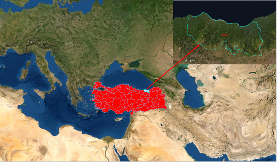
Figure 1. Study area
Slika 1. Područje istraživanja
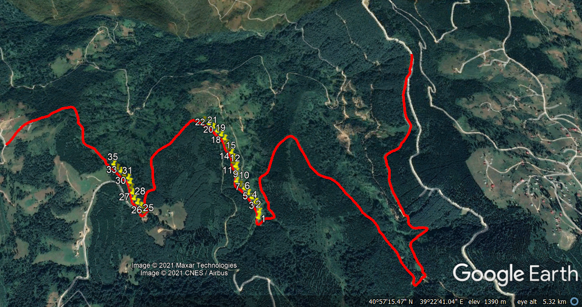
Figure 2. Sample areas – Road code 269
Slika 2. Područja uzorkovanja – Oznaka ceste 269
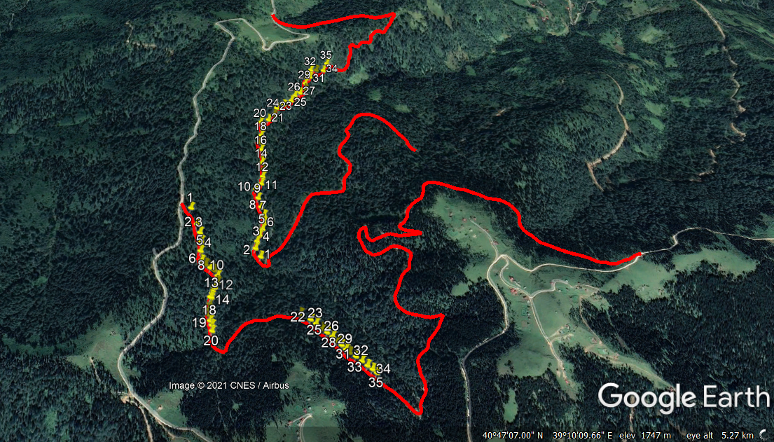
Figure 3. Sample areas – Road codes 307 and 315
Slika 3. Područja uzorkovanja – Oznake cesta 307 i 315
A total of 105 soil samples, 35 for each road, were taken from the fill slope of these selected roads. Soil samples were taken from the points where the road platform ends and the fill slope begins (Fig. 4).
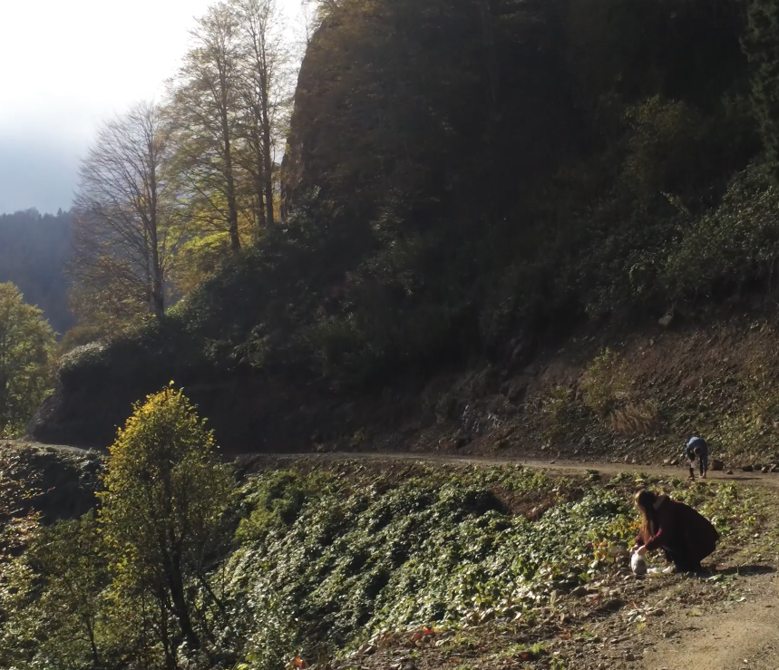
Figure 4. Taking soil samples
Slika 4. Uzimanje uzoraka tla
On the soil samples taken from these points, where the fill slope begins, the amount of organic matter and soil texture were determined in the laboratory environment, and as a result, the annual amount of soil loss was determined.
The universal soil loss estimation equation (USLE), one of the most widely used mathematical models, was used to estimate the amount of soil lost by erosion (Köhn et al. 2021). The ABAG method, which is a simulation of the USLE model converted to the metric system and adapted to European conditions, was used in the study (Wischmeier and Smith, 1978). Below are the components of this method:
(1)
In which:
A: The annual soil loss from the unit area obtained by multiplying the factor values (t / ha)
R: Precipitation factor (rainfall erosivity index). The R values, which are the precipitation factor (rainfall erosivity index), were processed based on the value to which Trabzon corresponds to on the map shown in Figure 5.
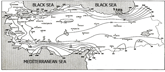
Figure 5. Average annual erosion indices’ distribution in Türkiye (Dogan, 1987)
Slika 5. Distribucija prosječnih godišnjih indeksa erozije u Turskoj (Dogan, 1987)
K: Soil erodibility (erosion susceptibility) factor. For the K factor, first of all, organic matter and soil texture analysis were performed in the laboratory and the K values were calculated using the equation below (Wischmeier and Smith, 1978):
(2)
OM = Soil organic matter content,
M = (% silt +% very fine sand) x (100-% clay),
S = Soil structure code
P = Permeability class.
LS: Slope length and slope factor. The length and slope of each fill slope were found in the field. The LS factor was determined by formulating the slope length and slope factor according to these values (Arnoldus, 1977).
(3)
In which:
C: Product management factor: The grid method was used to determine the soil cover ratio of the vegetation and to determine the C factor. Images taken with the Parrot Anafi Drone were used to determine the amount of vegetation (Ceylan et al., 2019). In order to surround 1x1 m2 for herbaceous plants, 2x2 m2 for shrub-shaped plants and 10x10 m2 for tree cover in the sample areas taken, square meters were entered with the command to enter the area on the drone interface, and images were taken from every point. The captured images were taken into 10x10 boxes and the degree of vegetation for each point was determined as a percentage (Pinar et al., 2018). The C factor values, which are the product management factor, were adapted to the formula according to the corresponding value in the C values’ table for continuous pasture, pasture or vacant land (Arnoldus, 1997).
P: Erosion control practices (soil protection measures) factor. It refers to the conservation techniques aimed at reducing soil erosion. P can also be defined as erosion control management practices. In the absence of any protective measures, the P factor can be determined as 1 (Schwab et al., 1993).
In this formula, the main variables were the K and C factors. Considering that the factors other than K and C will not differ due to the selection of the trial areas in the same ecological region, these factors were given priority.
Results and discussion – Rezultati i diskusija
In accordance with the observations in the field and the analysis of material, no vegetation was found on the newly built road (road code 315). On the 5-year-old road (road code 307), mostly annual plants (herbaceous and shrubs, etc.) were found, and on the 10-year-old road (road code 269), mostly annual trees, but in the form of bushes, as well as woodlands occasionally. The average vegetation cover ratio was determined as 93% on the road with the road code 269, 80% on the road with the road code 307, and 0% on the road with the road code 315.
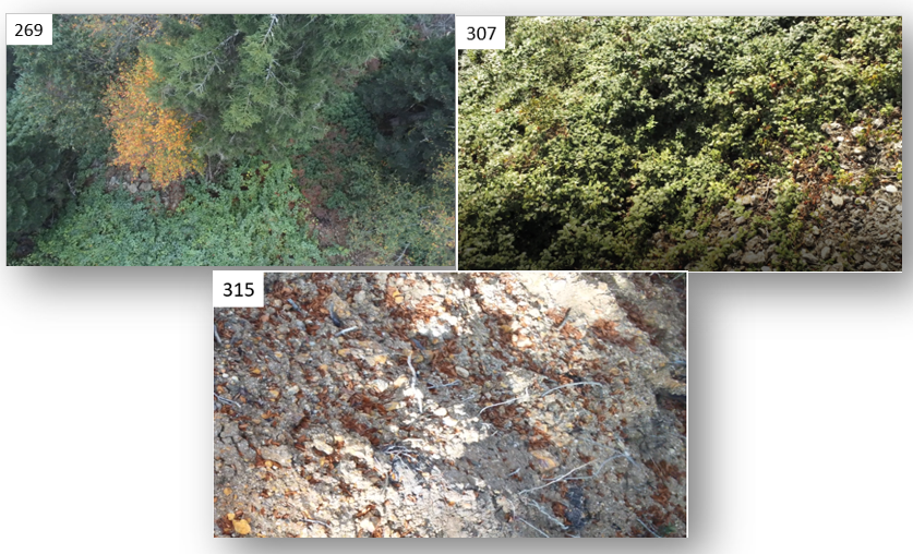
Figure 6. Vegetation of roads
Slika 6. Vegetacija na kosinama cesta
Since it is known that the plants in the study area are shallow-rooted, and are mostly grass and herbaceous plants, it follows the thesis by Yavuzsefik's (1998) that pile-rooted plants form the plant root system in landslides and shallow-rooted plants form the plant root system in areas with erosion risk. When we consider the cover rates, it can be seen that although the soil was completely bare in the first year the road was built, the plants that grew naturally in the area covered 80% of the soil within 5 years, and this rate gradually increased as the years passed. Luce and Black (1999) stated in their study that most of the soil losses occurred in the first two years until the excavation-fill slopes and ditches were completely covered with vegetation. Within the scope of this study, it was determined that the plants covered 80% or more soil in the 5th year, since the areas were analysed at 5 years intervals. Pohl et al. (2011) showed the positive effect of plant diversity on soil stability. In addition, the results by Pohl et al. (2011), who argue that total stability increases with increasing root density and the number of plant species, also support this study. In their study, Acar and Gumus (2018) observed that the vegetation cover was not formed in sufficient quantities despite the duration of 10 or 15 years. It is thought that the reason for this is the fact that their study was carried out in the Antalya region, which has characteristics of the Mediterranean climate and shows significant differences between the Eastern Black Sea Region in terms of soil characteristics.
According to the laboratory results, it was determined that the 269 coded road was 70% rock and 30% soil, the 305 coded road was 65% rock and 35% soil, and the 315 coded road was 75% rock and 25% soil. When the skeletal condition of all roads was measured, it was determined that more than 50% of the soil samples taken were larger than 2 mm. The average organic matter of the 10-year-old road was 4.94%, the average organic matter of the 5-year-old road was 4.79%, and the organic matter of the newly built road was 5.50%. Petri and Wagner (1978) divided the organic matter into 5 classes: poorly humic, lowly humic, medium humic, very humic, and humus-rich. According to this classification, the 10-year-old road coded 269 and the 5-year-old road coded 307 are in the category of medium humic, while the newly built road with the road code 315 is in the category of very humic. The reason why the organic matter of the newly built road is higher than the others may be the result of laying the humus layer, which has a high amount of organic matter in the upper soil, taken from the excavation slope, in the road construction (OGM, 2008). According to Monnier (1965), organic matter is considered to be an important parameter of annual soil loss, as it causes an increase in the mean weight diameter and consequently increases the overall stability. Refahi (2006) reported that soil abrasiveness decreases linearly with increasing organic matter in the range of 0 to 10%. Parsakhoo et al. (2014) found similar results in their study.
Calculations were made for all parameters according to the ABAG method and the following results were found.
Table 1. ABAG method parameters results
Tablica 1. Rezultati parametara metode ABAG
The result of all these values was added to the relevant formula and the A factor value was calculated. The results of the A factor value for each path are given in the graph below.
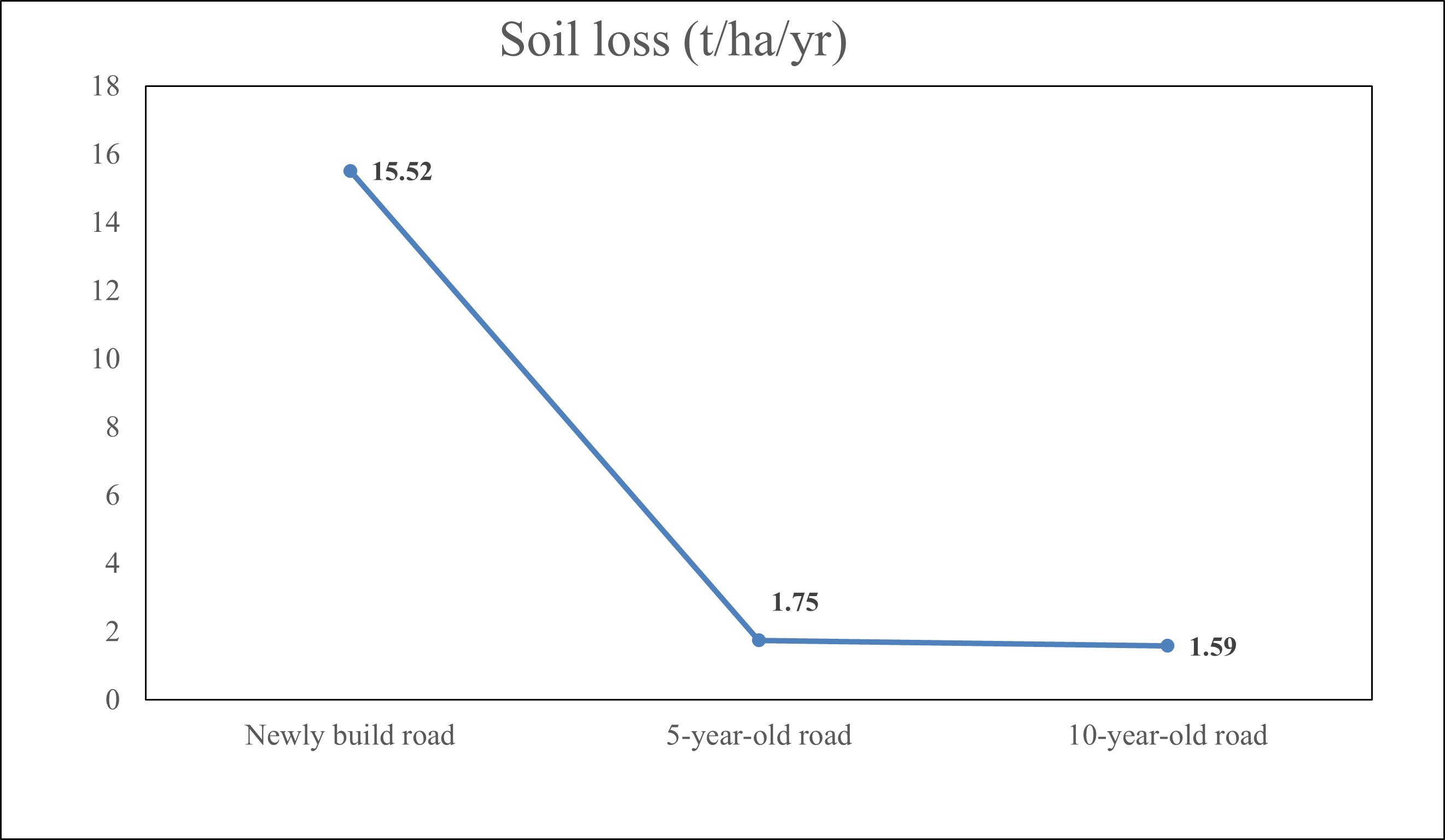
Figure 7.Annual amount of soil loss
Slika 7. Godišnja količina gubitka tla
According to the results of research conducted in various countries, it has been reported that annual soil loss varies between 0.03 and 5 t/ha/year in natural erosion and between 0.1 and 200 t/ha/year in accelerated erosion (Morgan, 2009). According to these data, the amount of erosion in the open area can vary from 3 to 280 t/ha/year, depending on the land structures and climate conditions in the countries.
In the results of this research, which was based on the ABAG method, it is striking that the amount of soil loss determined on the newly built road is significantly higher than the values calculated on the 5-year-old and 10-year-old forest roads, while the results determined on the 5-year-old and 10-year-old slopes are similar. The main reason for this similarity is thought to be related to the percentage of soil cover of natural vegetation. Lotfalian et al. (2019) found in a study that most of the erosion occurred in the first years (Arnáez et al. 2004) and reached a maximum level within 5 years and then decreased. Hacisalihoglu et al. (2019) found that the average annual amount of soil loss (for 0-50 cm depth level) was approximately 5.5 times higher in the open area according to the ABAG method. It was significantly affected by afforestation studies in a 40-year period, and the soil loss of afforestation was observed. It was determined that there is a variable that reduces the amount of soil and that the reason for this difference is the comparison of the open area and the afforestation area in their study. Within the scope of this study, both areas were located within the forest area.
Conclusion - Zaključak
In this study, the amount of soil erosion on the forest road fill slope was calculated as 15.52 t/ha/year on the newly built forest road, 1.75 t/ha/year on the 5-year-old forest road and 1.59 t/ha/year on the 10-year-old forest road. Considering that most of the soil loss determined in the study area occurred during the first years, it is predicted that the amount of soil loss, determined on the 5-year-old forest road, remains at an acceptable level according to the natural amounts of soil erosion.
It can be concluded the main reason for the differences in the amount of erosion are the C factor (land cover and management factor) and the K factor (erosion susceptibility). The usage of unmanned aerial vehicles for the detection of the C factor and vegetation has made it very convenient in the field. In order to find the K factor, soil organic matter content, texture, soil structure and permeability class were determined. For these, chemical analyses were conducted in the laboratory and as a result, the K factor values were obtained. Planting methods can be used to improve the K factor and the C factor. In order to accelerate the existing planting, it is recommended to carry out fertilization studies.
In this study, positive results were obtained regarding the restoration period of nature, which will be shortened gradually if the standards are compliant with the construction of forest roads. Therefore, laying the topsoil covering on the fill slopes, which was stripped during construction, after the slope surfaces are formed, will be important for the growth of surface vegetation by increasing the amount of organic matter. Since forest road construction is in direct interaction with nature, care should be taken to ensure that the people to be employed here are experienced forest engineers.
The results of this study conducted in the Eastern Black Sea Region produce data for areas with similar ecological conditions. It is recommended that this study is iterated in different regions or within the same region at different elevation levels, aspects, and climatic conditions, in order to produce more economic and ecological solutions for the precautions that need to be taken.
Acknowledgement: We would like to thank Prof. Dr. Sezgin Hacisalihoglu for her help in this study and Dr. Ugur Kezik who was with us during the laboratory studies.
Funding: This research was funded by Office of Scientific Research Projects of Karadeniz Technical University (Project No: FHD-2021-9268).
Conflict of interest: The authors declare that they have no known competing financial interests or personal relationships that could have appeared to influence the work reported in this paper.