License (open-access, http://creativecommons.org/licenses/by-sa/4.0/):
CC-BY-SA
License (open-access):
Prava korištenja: CC-BY-SA
License (open-access):
Journal content is published under CC-BY-SA licence.
Publication date: 2023
Volume: 22
Issue: 40
Book review
19th International Conference on Geoinformation and Cartography
Miljenko Lapaine
; Hrvatsko kartografsko društvo Međimurska 17, Zagreb
313537
27.12.2023.
![]()
Visits: 292 *
Zadar and online
7th – 9th September 2023
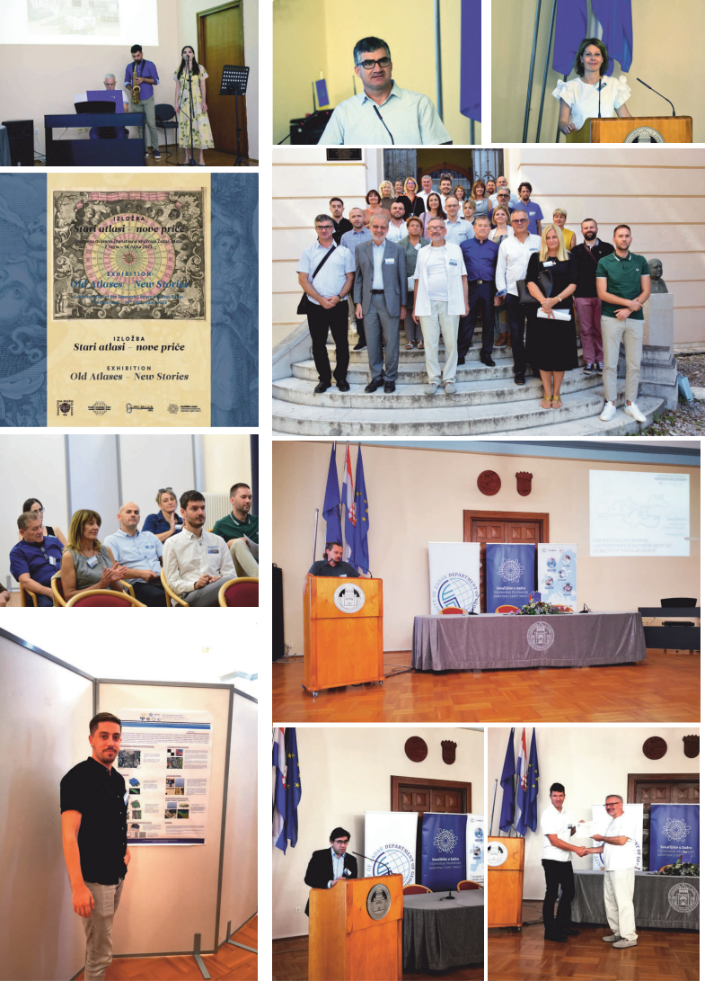
In collaboration with the Department of Geography - University of Zadar, the Faculty of Geodesy – University of Zagreb and the Croatian Geographical Society - Zadar, the Croatian Cartographic Society organised the 19th International Conference on Geoinformation and Cartography (19thICGC) in Zadar and online from 7th to 9th September 2023. The Conference was endorsed by the International Cartographic Association – ICA, EuroSDR, the University of Zadar and the University of Zagreb.
The conference programme and abstracts of lectures have been published in print and online. 200 attendees registered, out of which 40 onsite and 160 online. The official language was English. Peter Jordan and Joep Crompvoets were guest lecturers.
The conference programme started on 7th September 2023 in the ceremonial hall of the University of Zadar. The first keynote lecture followed the welcome speech. Peter Jordan gave a lecture on how to optimize toponymy on modern maps. After the lecture and a coffee break, six more lectures from the field of cartographic history were given. In late afternoon, the exhibition ‘Old Atlases – New Stories’ was opened in the Research Library in Zadar. Prof. Josip Faričić Ph.D., who was the author of both the exhibition and the catalogue, was aided by the employees of the Research Library and the State Archives in Zadar.
The second conference day started with a presentation by Assist. Prof. Dušan Petrovič Ph.D., the newly elected member of the ICA Executive Committee, on the mission and activities of the mentioned international society. The speaker revisited the recently held international cartographic conference in Cape Town, where Croatia won first place at the map exhibition in the educational cartographic product category. A few additional presentations on map projections followed as well as closing remarks given by Assist. Prof. Krisztian Kerkovits Ph.D, the newly elected chairman of the ICA Commission on Map Projections. After a coffee break and some refreshment we listened to the keynote lecture by Joep Crompvoets on the interpretation of geospatial technologies through the introduction of the Gartner hype cycle. Another presentation and a poster session followed after lunch. A guided tour of Zadar and its sites took place in the evening.
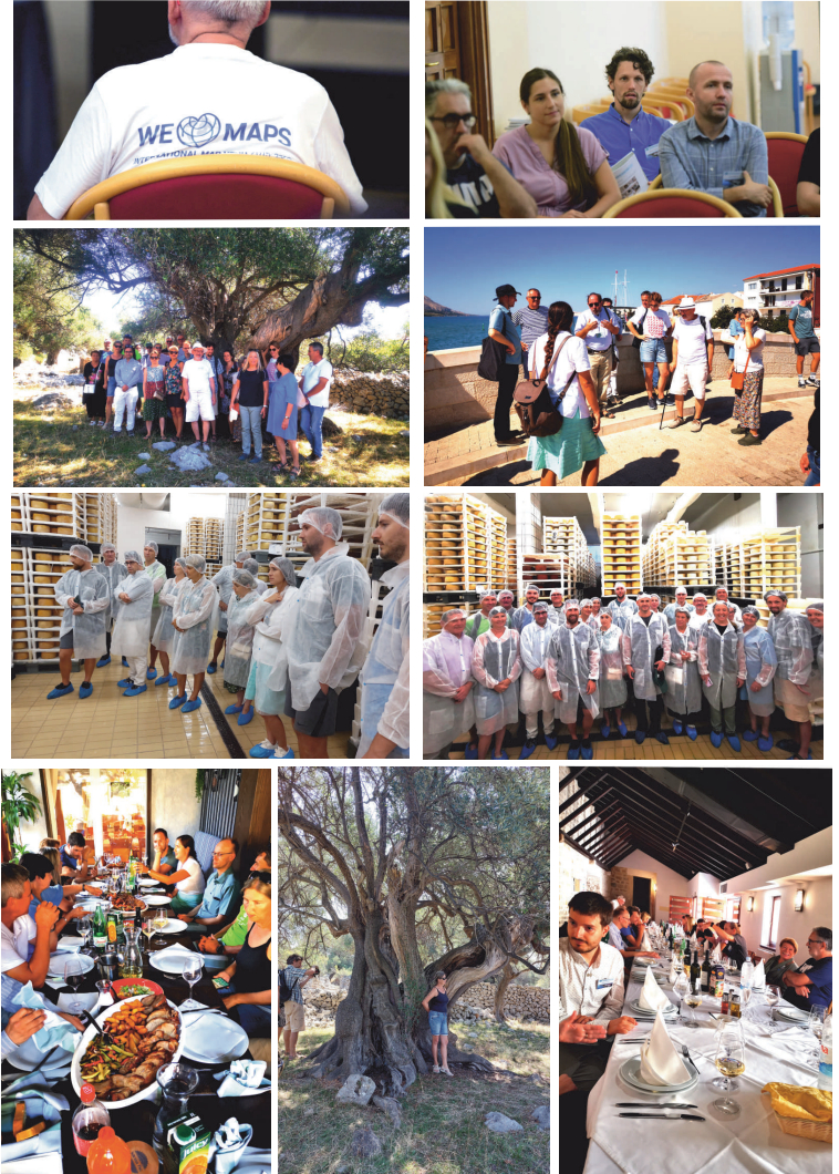
A guided tour of the island of Pag started at 9 o'clock on the third conference day from the parking lot in the vicinity of the Department of Geography – University of Zadar, F. Tuđmana 24i (new campus). A two-hour drive took us to Lun, famous for its spectacular olive grove with thousands of ancient olive trees, one of which is claimed to be more than 2000 years old and another around 1600 years old. We learned all about the basic characteristics of olive trees.
Afterwards we drove to Kolan, where we visited the famous Gligora cheese factory. The welcome speech included the story of the cheese from Pag, which is the most famous award-winning Croatian cheese. We took a tour of the factory, dressed appropriately in special protective clothes and accompanied by an expert guide. The visit ended in the tasting room overlooking the spectacular northern part of the island. Next was a short drive to the town of Pag, a visit to the Museum of Salt and a short tour of the town with an expert guide. Our visit to Pag came to an end in the famous restaurant Na Tale, where we had lunch.
Finally, one needs to thank the Organizing Committee, especially Assoc. Prof. Lena Mirošević, assist. Prof. Tome Marulić Ph.D., Julijan Sutlović mag. geo., Mr. Sc. Marija Brajković, the Croatian Geographical Society – Zadar and Prof. Josip Faračić Ph.D., the president of the International Scientific Committee and elected rector of the University of Zadar, whose utmost dedication made the conference such a great success.
All material from the 19th International Conference on Geoinformation and Cartography, including the photographs, programme and abstracts, is available at www.kartografija.hr.
Zadar i online
7–9. rujna 2023.
Hrvatsko kartografsko društvo u suradnji s Odjelom za geografiju Sveučilišta u Zadru, Geodetskim fakultetom Sveučilišta u Zagrebu i Hrvatskim geografskim društvom Zadar organiziralo je u Zadru i online 19. međunarodnu konferenciju o geoinformacijama i kartografiji (19thICGC) od 7. do 9. rujna 2023. Pokrovitelji konferencije bili su Međunarodno kartografsko društvo (International Cartographic Association − ICA), EuroSDR, Sveučilište u Zadru i Sveučilište u Zagrebu.
Program konferencije i sažetci predavanja objavljeni su u tiskanom i online izdanju. Za sudjelovanje na konferenciji bilo je 200 prijavljenih, od toga 40 uživo, 160 online. Službeni jezik konferencije bio je engleski. Pozvani predavači bili su Peter Jordan i Joep Crompvoets.
Program konferencije započeo je 7. rujna 2023. u svečanoj dvorani Sveučilišta u Zadru.
Nakon pozdravnih riječi uslijedilo je prvo pozvano predavanja. Peter Jordan govorio je o optimizaciji toponima na suvremenim kartama. Nakon toga, uz stanku za kavu, slušali smo šest prezentacija iz područja povijesti kartografije. U večernjim satima otvorena je u izložbenom prostoru Znanstvene knjižnice u Zadru izložba "Stari atlasi – nove priče". Autor izložbe i istoimenoga kataloga bio je prof. dr. sc. Josip Faričić, a njemu su u ostvarenju izložbe pomogli djelatnici Znanstvene knjižnice i Hrvatskoga državnog arhiva u Zadru.
Drugi dan konferencije započeo je izvještajem doc. dr. sc. Dušana Petroviča, novoizabranog člana Izvršnog odbora ICA-e o misiji i aktivnostima toga međunarodnoga društva. Posebno se osvrnuo na nedavno održanu međunarodnu kartografsku konferenciju u Cape Townu na kojoj je Hrvatska osvojila prvo mjesto na kartografskoj izložbi u kategoriji obrazovnih kartografskih proizvoda. Slijedilo je nekoliko prezentacija na temu kartografskih projekcija uz završnu riječ novoizabranoga predsjedavajućeg Povjerenstva za kartografske projekcije ICA-e, doc. dr. Krisztiana Kerkovitsa. Nakon stanke za kavu i osvježenje, poslušali smo pozvano predavanje Joepa Crompvoetsa o interpretaciji geoprostornih tehnologija uvođenjem Gartnerova hype ciklusa. Poslije ručka slijedila je još jedna prezentacija i izložba triju postera. U večernjim satima organiziran je stručni obilazak grada Zadra i njegovih znamenitosti.
Stručni obilazak otoka Paga trećega dana konferencije počeo je u 9:00 sati s parkirališta u neposrednoj blizini Odjela za geografiju Sveučilišta u Zadru, F. Tuđmana 24i (novi kampus). Vožnja do Luna poznatog po velikom masliniku, koji sadrži tisuće drevnih stabala maslina, uključujući jednu za koju se tvrdi da je stara 2000 godina i drugu za koju se tvrdi da je stara 1600 godina, trajala je dva sata. Tamo smo saznali osnovne karakteristike tih stabala.
Nakon toga odvezli smo se u mjesto Kolan, gdje smo posjetili poznatu siranu Gligora. Doček je bio uz uvodnu priču o paškom siru, najpoznatijem i nagrađivanom hrvatskom siru. Zatim smo razgledali siranu odjeveni u posebnu zaštitnu odjeću i obuću uz tumačenja stručnog vodiča. Posjet sirani završio je degustacijom sireva u kušaonici na katu, s prekrasnim pogledom na sjeverni dio otoka Paga. Slijedila je kraća vožnja do grada Paga, posjet Muzeju soli i kraći obilazak grada uz stručnog vodiča. Posjet Pagu završio je ručkom u poznatom restoranu Na Tale.
Na kraju ovoga kratkog izvještaja treba zahvaliti Organizacijskom odboru, posebno izv. prof. Leni Mirošević, doc. dr. sc. Tomi Mareliću, Julijanu Sutloviću, mag. geogr., mr. sc. Mariji Brajković, Hrvatskom geografskom društvu – Zadar i prof. dr. sc. Josipu Faričiću, predsjedniku Međunarodnog znanstvenog odbora konferencije i izabranom rektoru Sveučilišta u Zadru čijom zaslugom je konferencija bila tako uspješna.
Svi materijali s 19. međunarodne konferencije o geoinformatici i kartografiji, uključujući fotografije, program i sažetke, dostupni su na www.kartografija.hr.