
Proposal of a Database Model for Recording Maps and Cartographic Material of the Monastery of the Holy Spirit in Fojnica
Slobodanka Ključanin
Tehnički fakultet – Građevinski odsjek, Univerzitet u Bihaću, Bihać, Bosna i Hercegovina
Technical Faculty – Department of Civil Engineering, University of Bihać, Bihać, Bosnia and Herzegovina
slobodanka63@yahoo.com
Sažetak: Samostan Duha Svetoga posjeduje vrijednu zbirku knjiga, karata, kartografske građe i drugih povijesnih dokumenata, skupljanih i sačuvanih tokom 650 godina svog postojanja. Knjižno blago je popisano i predstavljeno javnosti, dok se karte i kartografska građa1 nikad nisu evidentirali. Zbog toga je Univerzitet u Sarajevu, Građevinski fakultet – odsjek Geodezija predložio Franjevačkom samostanu Duha Svetoga u Fojnici istraživački projekt pod nazivom “Inventarizacija kartografske građe”, koja je podrazumijevala formiranje baze podataka u svrhu evidentiranja karata i kartografske građe. Takva baza podataka omogućava pregledno pretraživanje podataka o kartama i kartografskoj građi. Gvardijan samostana je prihvatio predloženi projekt te omogućio istraživačima pristup dijelu karata i kartografske građe koje čuvaju u svom arhivu i muzeju. Projekt je uspješno realiziran, kreirana je baza podataka koja je poslužila za tiskanje “Kataloga karta i kartografske građe samostana ‘Duha Svetoga’ u Fojnici”. U ovom članku detaljno je opisan postupak modeliranja baze podataka za evidentiranje karata i kartografske građe samostana Duha Svetoga u Fojnici.
Ključne riječi: karta, kartografska građa, model baze podataka, baza podataka, katalog.
Abstract: The Franciscan Monastery of the Holy Spirit has a valuable collection of books, maps, cartographic materials and other historical documents, collected and preserved during the 650 years of its existence. The treasure in books was catalogued and presented to the public, while maps and cartographic material2 were never recorded. Therefore, the University of Sarajevo, Faculty of Civil Engineering – Department of Geodesy proposed to the Franciscan Monastery of the Holy Spirit in Fojnica a research project entitled “Inventory of cartographic material”, which involved the formation of a database to record maps and cartographic material. Such a database enables a clear search of data on maps and cartographic material. The Prior of the Monastery accepted the proposed Project, and gave the researchers access to a part of the maps and cartographic materials that they keep in their archive and museum. The project was successfully realized, a database was created which was used to print the “Catalogue of maps and cartographic materials of the monastery of the ‘Holy Spirit’ in Fojnica.” This article describes in detail the process of modelling a database for recording maps and cartographic material of the monastery Holy Spirit in Fojnica.
Keywords: map, cartographic material, database model, database, catalogue.
1. Uvod
Franjevački samostan Fojnica smješten je u središnjoj Bosni, između Sarajeva i Bugojna. U desetom stoljeću u Fojnicu su dolazili rudari iz europskih zemalja radi eksploatacije i prerade ruda. S rudarima su stigli i franjevci koji su se smjestili u Pazarnici. Tu su, krajem XIV stoljeća, izgradili crkvu i posvetili je Sv. Mariji, a uz nju su izgradili i samostan. Godine 1502. izgradili su novi samostan na brdu Križ, gdje se i danas nalazi (Ljubos 2021). Crkva i samostan su proglašeni nacionalnim spomenicima u Bosni i Hercegovini u listopadu 2011. godine (Komisija za očuvanje nacionalnih spomenika Bosne i Hercegovine 2011).
Kroz dugi period postojanja samostana (preko 650 godina) prikupljani su i sačuvani mnogi zapisi i predmeti od povijesnog, kulturnog i vjerskog značaja. Stoga su formirane dvije knjižnice. Jedna nosi radni naziv “knjižnica novih knjiga”, tj. knjiga koje su tiskane od 1850. godine do danas. Druga nosi radni naziv “knjižnica starih knjiga i dokumenata”, odnosno knjiga i dokumenata čiji je datum nastanka od prije 1850. godine. Knjižnica starih knjiga broji oko 10.000 naslova iz različitih područja (teologije, matematike, fizike, kemije, zemljopisa, medicine, jezikoslovlja, književnosti, prava (civilno i crkveno), psihologije, glazbe (crkvene i svjetovne), itd.). Posjetitelji u muzeju i knjižnici mogu vidjeti samo dio blaga koje samostan posjeduje (Ljubos 2021). Samostanski arhiv dostupan je istraživačima. Evidentirane su knjige, dokumenti, umjetničke slike i drugi predmeti. Međutim, karte i kartografska građa samostana Duha Svetoga u Fojnici nisu evidentirane ni u kakvom tipu evidencije, nego su rasute po različitim ormarima, ladicama i fasciklama. U današnje vrijeme, kad tehnologija omogućava pohranjivanje podataka o kartama (i samih karata) u digitalnom obliku, kao i mogućnost njihove vizualizacije na različitim medijima (ekran računala, mobitela ili se mogu otiskati na papir) i korištenja za različite potrebe (navigacija, pretraga po objektima, osobna istraživanja i sl.), logičan korak ka naprijed je modeliranje odgovarajuće baze podataka za evidentiranje karata i kartografske građe.
2. Modeliranje baze podataka za evidentiranje karata i kartografske građe samostana Duha Svetoga u Fojnici
S obzirom na to da je informacijski sustav uvijek podsustav nekog organizacijskog sustava, svrha mu je prikupljanje, obrada, pohranjivanje i distribucija podataka koji su potrebni za praćenje rada i upravljanje tim organizacijskim sustavom ili nekim njegovim podsustavom. Baza podataka je centralno mjesto informacijskog sustava. Pohranjeni podaci u bazi podataka opisuju trenutačno stanje objekta za koji je razvijen informacijski sustav (Medak 2008, 12). U njoj se nalaze pohranjene strukture i algoritmi koje korisnici ne vide. Podaci u bazi podataka logički se strukturiraju odgovarajućim modelom podataka (Ključanin 2006, 7).
Modeli podataka definiraju koji su podaci potrebni za opis objekata od interesa, te obavezni i neobavezni atributi koji prate taj objekt. Također definiraju međusobne relacije između objekata. Stvaranje modela podataka dijeli se u tri faze: konceptualno dizajniranje, logički dizajn i fizičko (tehničko) dizajniranje baze podataka.
2.1. Konceptualno modeliranje baze podataka
Cilj konceptualnog modeliranja podataka jest opisati strukturu podataka, koja će se čuvati u bazi podataka, s obzirom na vrste prostornih objekata, njihovih međusobnih odnosa, objektne klase, udruživanja i atribute. Konceptualni model podataka daje cjelovit i neredundantan opis podataka informacijskog sustava (freeservers 2020). On je temelj za razvoj logičkog i fizičkog modela. Konceptualnim modelom definira se predviđena upotreba podataka (tj. neophodni zahtjevi za izradu topografske karte). Često se naziva i semantičkim modelom. Opisivanje strukture podataka podrazumijeva koji će objekti biti zastupljeni u bazi podataka (spisak obaveznih i neobaveznih atributa), identifikaciju odnosa između objekata, kao i uvjeta koji moraju biti zadovoljeni. Budući da ti opisi ne uključuju detalje implementacije, rezultat procesa modeliranja podataka je (polu)formalni prikaz strukture baze podataka. Postupak izrade bilo koje, pa tako i baze podataka karata i kartografske građe, podrazumijeva postupak izrade konceptualnog modela podataka.
Nakon procesa fizičkog pronalaženja i vizualnog pregled karata i kartografske građe koja se nalazi u samostanu, pronađeni je materijal grupiran u sljedeće skupine:
Za svaku od navedenih skupina definira se određen broj karakterističnih atributa, koji su potrebni za njihovo identificiranje.
2.2. Logičko modeliranje baze podataka
Za razliku od konceptualnog modela, koji ne zavisi od tipa sustava i računalne platforme, struktura podataka postaje detaljnija i sve bliža fizičkoj bazi podataka. Logičko modeliranje podrazumijeva detaljnu razradu konceptualnog modela, tj. definiraju se obavezni i neobavezni atributi objektne klase, kao i veze s drugim objektnim klasama i njihovim atributima (Slika 1.).
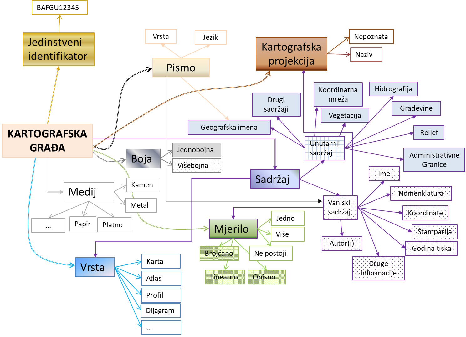
Slika 1. Razrada konceptualnog modela Kartografske građe
Ti se atributi koji opisuju određenu skupinu definiraju na osnovi toga moraju li se upisati u bazu podataka, tj. je li atribut obavezan ili nije. Tako, na primjer, za određenu skupinu karata ili kartografske građe biraju se određeni brojevi ili svi niže predloženi atributi:
Identifikacijski broj (O)
Posebna oznaka kartografske građe (N)
Kartografski period kojem pripada karta (N)
Vrsta karte (tematska, topografska, astronomska i sl.) (N)
Službena publikacija (N)
Broj primjeraka (O)
Stanje kartografske građe (N)
Naslov originala (O)
Prijevod originalnog naslova (N)
Ime i prezime autora karte (O)
Izdavač (O)
Dimenzije karte (O)
Orijentacija karte prema stranama svijeta (N)
Lista boja korištenih na karti (N)
Vrsta mjerila (grafičko, brojčano, nepoznato) (N)
Vrijednost brojčanog mjerila (O)
Materijal na kojem je karta iscrtana (papir, kartografski papir, karton itd.) (O)
Prikaz reljefa (N)
Kartografska projekcija (O)
Početni meridijan (O)
Mreža paralela i meridijana (da / ne) (N)
Legenda (da / ne) (N)
Jezik pisma na karti (O)
Pismo (O)
Zemlja izdavanja (O)
Vrsta reprodukcije (N)
Pojedinosti izrade / reprodukcije (N)
Godina tiskanja (O)
Napomena (N),
gdje (O) znači da se atribut obavezno mora upisati u bazu podataka, a (N) znači da je atribut neobavezan, tj. da se može upisati ako postoji ili ako se smatra potrebnim za određenu skupinu građe.
2.3. Fizičko modeliranje baze podataka
Fizički je model podataka najviše vezan za korisnički hardver i softver. Fizičko modeliranje predstavlja formiranje baze podataka pomoću odabranog Data Base Management System (DBMS) na odabranom hardveru.
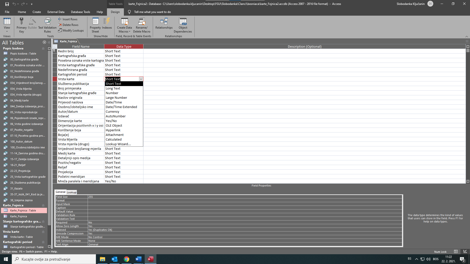
Slika 2. Definiranje tipa zapisa (za Vrstu karte) u access bazi podataka
Fizičko modeliranje podrazumijeva fizičko stvaranje tablica s odgovarajućih atributa kojima je definiran tip zapisa3 (Slika 2.).
Također se fizički formiraju veze između tablica koje su definirane logičkim modelom baze podataka (Slika 3. i 4.).
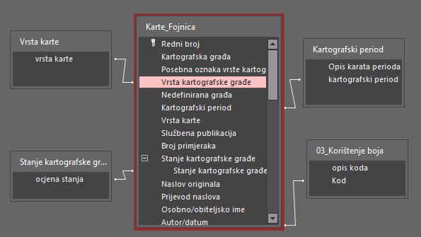
Slika 3. Povezivanje tablica
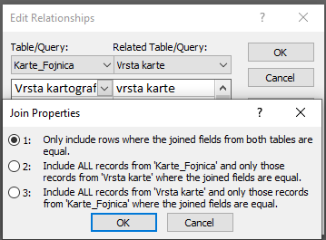
Slika 4. Definiranje veza između polja tablice Karte_Fojnica i Vrsta karte
3. Unos podataka kartografske građe u bazu podataka
Postoje različite tehnike unosa podataka u bazu. Uglavnom se dijele u dvije skupine: prevođenje analognih podataka u digitalni oblik (enciklopedija 2021) i preuzimanje digitalnih podataka iz različitih izvora. Kartografska građa je fotografirana digitalnim aparatom, a slike su prenesene na hardver, te povezane s bazom podataka stvaranjem odgovarajućeg hiperlinka. Metapodaci, tj. podaci o svakom pojedinačnom primjerku kartografske građe, uneseni su putem tipkovnice.
U bazu podataka uneseni su putem tipkovnice metapodaci o 303 pojedinačne karte (neke od njih su u više primjeraka) i 376 karata koje se nalaze u udžbenicima i knjigama, novinskim isječcima i ostaloj dokumentaciji, te dva atlasa (Atlas Universel, tiskan u Veneciji 1776. godine, i Atlas Universel seconde partie du nouvel atlas, tiskan u Veneciji 1780. godine). Na Slici 5. vidi se dio forme za unos metapodataka kartografske građe.
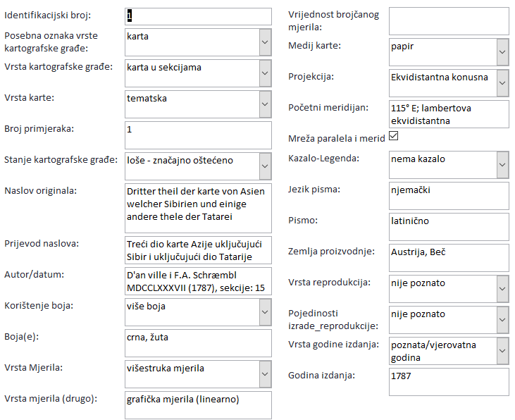
Slika 5. Prikaz ekrana za unos metapodataka
Nakon unosa podataka u bazu, omogućena je pretraga (Slika 6.) i postavljanje upita o kartografskoj građi.
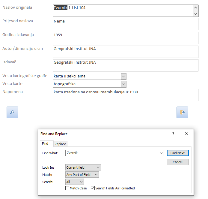
Slika 6. Prikaz ekrana u slučaju pretrage po naslovu originala
Na taj način se na jednostavan način omogućava korisniku da u vrlo kratkom roku provjeri postoji li karta koja ga interesira, te je moguće podnijeti zahtjev za njeno korištenje.
4. Katalog karata i kartografske građe samostana Duha Svetoga u Fojnici
Da bi podaci o kartama i kartografskoj građi samostana bili dostupni širokom krugu korisnika, pored baze podataka (koja je kreirana za internu upotrebu knjižničara) uređen je i Katalog karata i kartografske građe samostana Duha Svetoga u Fojnici (monografija). Izdavač ovog Kataloga je Građevinski fakultet u Sarajevu, a tiskan je u tiražu od 300 komada.
Tablica 1. Primjerci karata i odabrani atributi (Ključanin 2016, 54, 61)
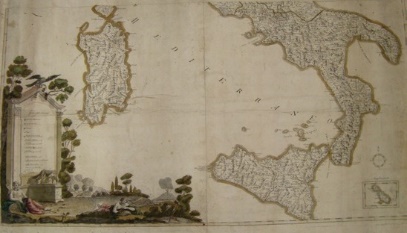
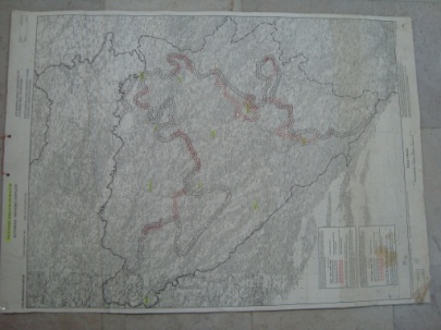
Katalog omogućava vizualni pregled odabranih primjeraka karata i kartografske građe te određeni broj njihovih atributa iz baze podataka – identifikacijski broj primjerka, fotografiju primjerka, originalni naziv karte, prijevod naziva karte, godinu izdanja karte, informaciju je li primjerak pojedinačan ili je dio drugog djela, autor(e) primjerka, izdavača, dimenzije, mjerilo, reljef (ako je prikazan), nulti meridijan, koordinatnu mrežu, stanje primjerka, broj primjeraka i ostale informacije (Tablica 1.).
5. Zaključak
Kartografska građa sastavni je dio fondova mnogih knjižnica, kako nacionalnih, tako i sveučilišnih, narodnih, školskih itd. Definiranjem kartografske građe prema međunarodnim standardima jasno joj određujemo ulogu i mjesto u fondu i djelatnosti pojedine knjižnice i ustanove (Miletić Drder i Gošljević 2014, 300). Kartografska građa je sastavni dio i samostana Duha Svetoga, ali nema određenu ulogu i mjesto u djelatnosti njegove knjižnice. Projekt Inventarizacija kartografske građe samostana Duha Svetoga u Fojnici rezultirao je formiranjem baze podataka i Kataloga karata samostana Duha Svetoga. Time je olakšano čuvanje i održavanje karata i drugih kartografskih dijela prikupljenih tijekom stoljeća. Također je zainteresiranim osobama olakšan pristup kartografskom blagu koje čuva ovaj samostan. Mora se spomenuti da posao inventarizacije kartografske građe u ovom samostanu nije završen, jer je za potrebe realizacije ovog projekta bio odobren pristup određenom broju karata i kartografske građe i u kratkom vremenskom periodu. Jasno je da nakon formiranja baze podataka postoji potreba za više različitih znanstvenoistraživačkih i stručnih projekata koji će imati za cilj realizaciju knjižničke kategorizacije kartografske građe, kao i istraživanje povijesnih činjenica koje se mogu utvrditi kroz prikazani sadržaj karata. Rezultat ovog projekta je otkrivanje postojećeg kartografskog blaga samostana Duha Svetoga javnosti u Bosni i Hercegovini i regiji, kao i popularizacija muzeja i arhiva samostana.
1. Introduction
The Franciscan monastery in Fojnica is located in central Bosnia, between Sarajevo and Bugojno. In the tenth century, miners from European countries came to Fojnica for the exploitation and processing of ores. The Franciscans, who settled in Pazarnica, also arrived with the miners. There, at the end of the 14th century, they built a church and dedicated it to St. Mary, and next to it they built a monastery. In 1502, they built a new monastery on the hill Križ (Cross), where it is still located today (Ljubos 2021). The church and monastery were declared national monuments in Bosnia and Herzegovina in October 2011 (Commission to Preserve National Monuments of Bosnia and Herzegovina 2011).
During the long period of the monastery’s existence (over 650 years) many records and objects of historical, cultural and religious significance were collected and preserved. Therefore, two libraries were formed. One has the working title “library of new books”, i.e. books that have been printed from 1850 until today. The second is called “library of old books and documents”, i.e. books and documents whose date of origin is from before 1850. The library of old books has about 10,000 titles from various fields (theology, mathematics, physics, chemistry, geography, medicine, linguistics, literature, law (civil and ecclesiastical), psychology, music (ecclesiastical and secular), etc.). Museum and library visitors can see only part of the treasures that the monastery owns (Ljubos 2021). The monastery archive is available to researchers. Books, documents, paintings and other objects are recorded. However, the maps and cartographic material of the Monastery of the Holy Spirit in Fojnica are not recorded in any type of records, but are scattered in various cabinets, drawers and folders. Nowadays, when technology enables the storage of map data (and the maps themselves) in digital form, as well as the possibility of their visualization on various media (computer screen, mobile phone or can be printed on paper) and use for various purposes (navigation, object search, personal research, etc.), a logical step forward is to model an appropriate database for recording maps and cartographic material.
2. Modelling of the database for recording maps and cartographic material of the Monastery of the Holy Spirit in Fojnica
Since the information system is always a subsystem of an organizational system, and its purpose is to collect, process, store, and distribute data, which are needed to monitor the operation and management of the organizational system or a subsystem, the database is the central place of the information system. The data stored in the database describe the current state of the object for which the information system has been developed (Medak 2008, 12). It contains stored structures and algorithms that users cannot see. The data in the database is logically structured by an appropriate data model (Ključanin 2006, 7).
Data models define what data is needed to describe an object of interest, and the mandatory and optional attributes that accompany that object. They also define the interrelationships between objects. Creating a data model is divided into three phases: conceptual design, logical design, and physical (technical) design of the database.
2.1. Conceptual database modelling
The goal of conceptual data modelling is to describe the data structure, which will be stored in the database, with regard to the types of spatial objects, their interrelationships, object classes, mergers, and attributes. The conceptual data model provides a complete and non-redundant description of information system data (freeservers 2020). It is the foundation for the development of a logical and physical model. The conceptual model defines the intended use of the data (i.e. the necessary requirements for constructing a topographic map). It is often called the semantic model. Describing the data structure implies which objects will be represented in the database (list of mandatory and optional attributes), identification of the relationship between objects, as well as the conditions that must be met. Because these descriptions do not include implementation details, the result of the data modelling process is a (semi)formal representation of the database structure. The process of creating any, including a database of maps and cartographic material, implies the process of creating a conceptual data model.
After the process of physical finding and visual inspection of maps and cartographic material located in the Monastery, the found material was grouped into the following groups:
For each of these groups, a number of characteristic attributes are defined, which are needed for their identification.
2.2. Logical database modelling
Unlike the conceptual model, which does not depend on the type of system and computer platform, the data structure becomes more detailed and closer to the physical database. Logical modelling implies a detailed elaboration of the conceptual model, i.e. the obligatory and optional attributes of the object class are defined, as well as the connections with other object classes and their attributes (Figure 1).
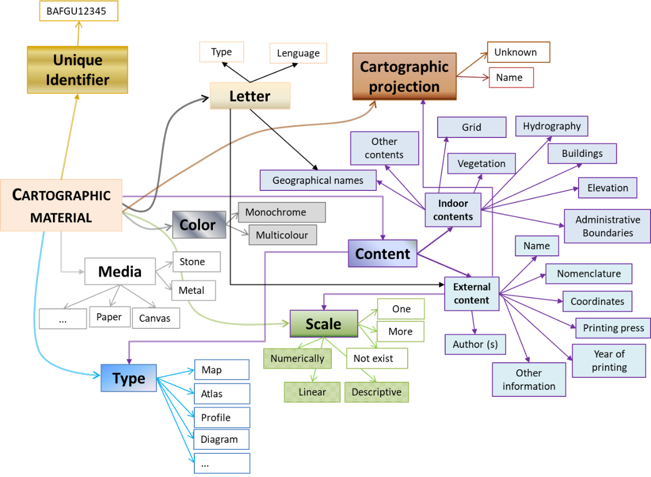
Figure 1 . Elaboration of the conceptual model of Cartographic material
These attributes that describe a particular group are defined in terms of whether it must be entered in the database, i.e., whether the attribute is mandatory or not. Thus, for example, for a certain group of maps or cartographic materials, a certain number or all of the following attributes are chosen:
Identification number (O)
Specific marking of cartographic material (N)
Cartographic period to which the map belongs (N)
Type of map (thematic, topographic, astronomical, etc.) (N)
Official publication (N)
Number of copies (O)
Condition of cartographic material (N)
Original title (O)
Translation of the original title (N)
Name and surname of the author of the map (O)
Publisher (O)
Map dimensions (O)
Map orientation by the sides of the world (N)
List of colours used on the map (N)
Scale type (graphical, numerical, unknown) (N)
Numerical scale value (O)
Material on which the map is drawn (paper, cartographic paper, cardboard, etc.) (O)
Relief display (N)
Cartographic projection (O)
Prime meridian (O)
The network of parallels and meridians (Yes/NO) (N)
Legend (Yes/NO) (N)
Language on the map (O)
Script (O)
Country of publishing (O)
Reproduction type (N)
Production / reproduction details (N)
Year of printing (O)
Note (N),
where (O) means that the attribute obligatory must be entered in the database, and (N) means that the attribute is optional, i.e. it can be entered if it exists or if it is considered necessary for a certain group of material.
2.3. Physical modelling of a database
The physical data model is most closely related to user hardware and software. Physical modelling is the formation of a database using the selected Data Base Management System (DBMS) on the selected hardware.
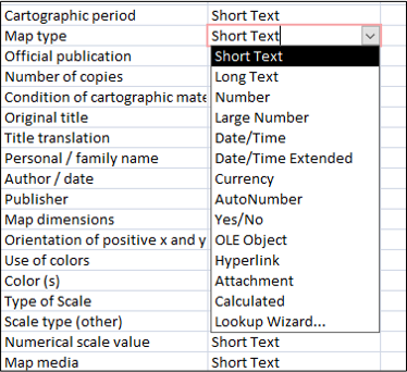
Figure 2. Defining the record type (for Map type) in the access database
Physical modelling involves the physical creation of tables with appropriate attributes, which define the record type4 ( Figure 2).
Links are also physically formed between the tables defined by the logical model of the database (Figures 3 and 4).
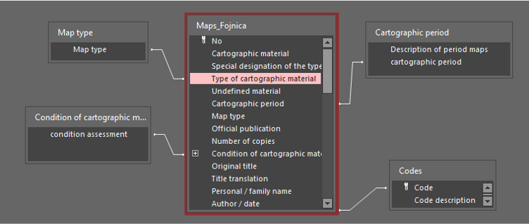
Figure 3. Linking tables
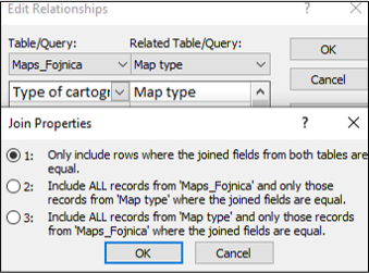
Figure 4. Defining the links between the fields of the table Maps_Fojnica and Map type
3. Entering cartographic data into the database
There are different techniques for entering data into the database. They are mainly divided into two groups: translating analogue data into digital form (encyclopaedia 2021) and downloading digital data from different sources. The cartographic material was photographed with a digital camera, and the images were transferred to the hardware and connected to the database by creating a corresponding hyperlink connection. Metadata, i.e. data on each individual copy of the cartographic material, were entered via the keyboard.
Metadata about 303 individual maps (some of them in several copies) and 376 maps in textbooks and books, newspaper clippings and other documentation, as well as two atlases, (Atlas Universel, printed in Venice in 1776, and Atlas Universel seconde partie du nouvel atlas, printed in Venice in 1780) were entered into the database via the keyboard. Figure 5 shows part of the cartographic metadata entry form.
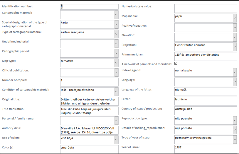
Figure 5. Display of the metadata entry screen
After entering the data into the database, it is possible to search (Figure 6) and query of the cartographic material.
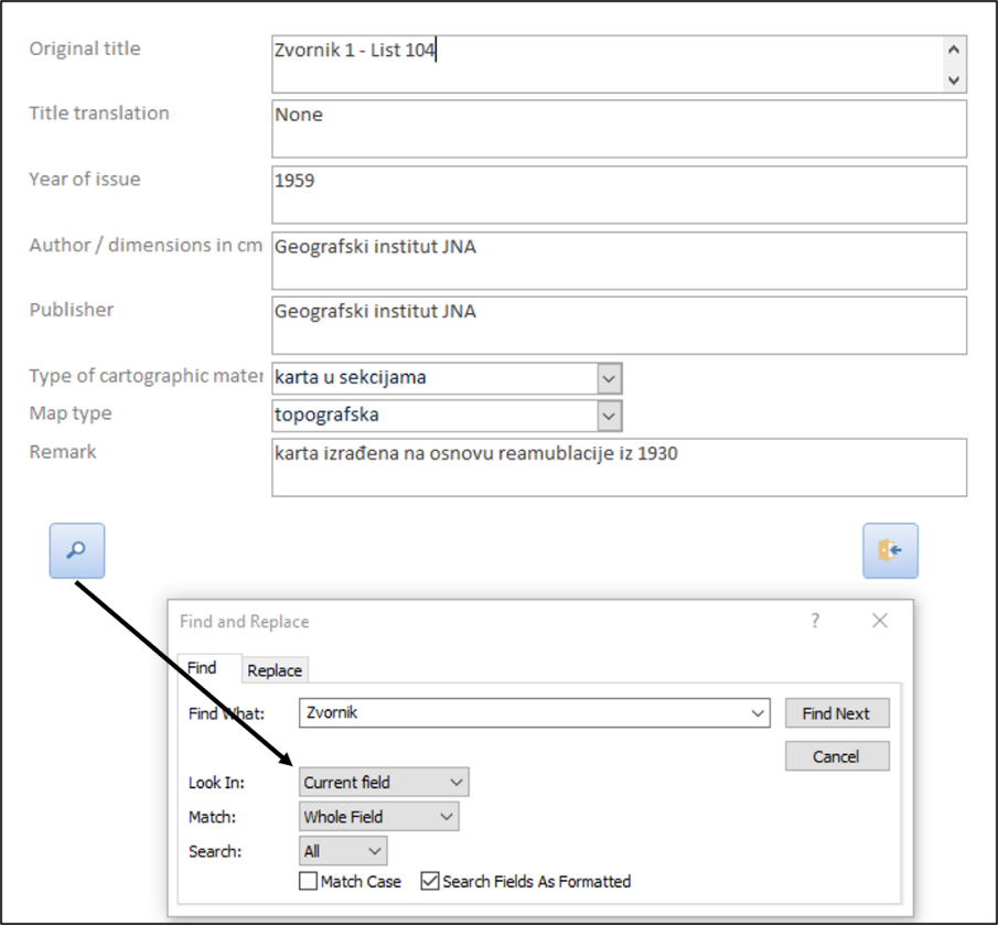
Figure 6. Screen display in case of original title search
In this mode, it is possible in a simple way for the user to check in a very short time whether there is a map that interests him, and it is possible to apply for its use.
4. Catalogue of maps and cartographic materials of the Monastery of the Holy Spirit in Fojnica
In order to make data on maps and cartographic material of the Monastery available to a wide range of users, in addition to the database (created for internal use by librarians), the Catalogue of Maps and Cartographic Material of the Monastery of the Holy Spirit in Fojnica has been edited (monograph). The publisher of this Catalogue is the Faculty of Civil Engineering in Sarajevo, and it is printed in a circulation of 300 copies.
Table 1. Map copies and selected attributes (Ključanin 2016, 54 i 61)
The catalogue provides a visual overview of selected copies of maps and cartographic material, and a number of their attributes from the database (identification number of the copy, photo of the copy, original name of the map, translation of the map title, year of publishing, information whether the copy is individual or part of another work, author(s) of the copy, publisher, dimensions, scale, relief (whether is shown or not), Greenwich meridian, grid coordinates, condition of the copy, number of copies and other information (Table 1).
5. Conclusion
Cartographic material is an integral part of the funds of many libraries, both national and university, public, school, etc. By defining cartographic material according to international standards, we clearly determine its role and place in the fund and activities of individual libraries and institutions (Miletić Drder and Gošljević 2014, 300). The cartographic material is an integral part of the Monastery of the Holy Spirit, but it does not have a specific role and place in the activities of its library. The project – Inventory of the cartographic material of the Monastery of the Holy Spirit in Fojnica – resulted in the formation of a database and catalogue of maps of the Monastery of the Holy Spirit. This has facilitated the storage and maintenance of maps and other cartographic works collected over the centuries. It is also easier for interested persons to access the cartographic treasures kept by this Monastery. It must be mentioned that the work of inventory of cartographic material in this Monastery has not been completed, because for the purposes of this Project, access to a certain number of maps and cartographic material was approved in a short period of time. It is clear that after the formation of the database, there is a need for several different scientific research and professional projects that will attain the objective of the library categorization of cartographic material, as well as research of historical facts that can be determined through the presented content of maps. The result of this project is the discovery of the existing cartographic treasure of the Monastery of the Holy Spirit to the public in Bosnia and Herzegovina and the region, as well as the popularization of the Museum and archives of the Monastery.