
INTRODUCTION
Many public datasets in many countries are made available as Open Government Data (OGD). Also, the data from National Continuously Operating Reference Station networks (NCORS) are provided as OGD in many countries. NCORS networks collect and process data from the Global Navigation Satellite Systems (GNSS) to provide precise positioning data to support spatially related activities. NCORS governing entities have applied different approaches to ensure the stability and functionality of their NCORS under the OD landscape. The countries’ experiences and lessons should benefit many other countries facing similar OD-NCORS implementation challenges.
This article explores the approaches, impacts and results of OD implementation on NCORS ecosystems in three members of the European Union (EU): the Netherlands, Sweden, and Germany. After the introduction, an overview of NCORS from a data perspective is elaborated together with an NCORS data ecosystem conception. After that, the concept is applied to explore the cases. The findings are discussed in the next part. Lastly, based on the exploration, this article provides considerations for stakeholders in implementing OD on NCORS in other countries and the implementation of OD on other datasets.
WHAT IS NCORS
CORS is a collective term for ground stations that observe signals from GNSS such as Global Positioning System (GPS), Global Navigation Satellite System (GLONASS), BeiDou and Galileo. In general, CORS can refer to a station or a network of ground stations. The latter one is called a CORS network. CORS can be categorised into three hierarchical levels: global, national and local networks[1]. At national levels, many national governments have established CORS as an infrastructure[2-4] to support several positioning activities. The CORS networks operated by the national governments can be considered National CORS networks or NCORS. In many countries, there are commercial CORS (CCORS) networks.
The functions of NCORS are first to support positioning standardisation through access to the national spatial reference frame, the fundamental function of NCORS data is to allow access to the geodetic reference frame[5-7]. Secondly, NCORS support positioning accuracy through correction services. Thirdly, NCORS serves also national time synchronisation[8].
NCORS has become a requirement for many development initiatives. For smart city initiatives, the precise positioning data from CORS can support the location services such as traffic management, autonomous vehicles and emergency services[9,10]. NCORS supports digital cadastral[2,3] as part of E-government initiatives[4]. Precision Agriculture (PA) applies spatial technologies[11]as “right treatment in the right place at the right time”[12] The PA functions such as precision soil preparation, seeding, crop management, precision harvesting, and data analysis and evaluation benefit from NCORS data[11,13,14]
A DATA PERSPECTIVE OF NCORS
The function of NCORS is to provide data that improve the accuracy of and standardise other positioning data. NCORS data serve as a national geospatial data framework – the data that other spatial data are built upon[15]. NCORS data serve the correction services for GNSS positioning. With these two functions, users can collect, process, and distribute the high precision spatial data that are interoperable with other spatial data in the national reference frame. The flows of NCORS data in serving the two functions are provided both in real-time data through Real-Time Kinematic (RTK), Differential GNSS (DGNSS) and Precise Point Positioning (PPP) services. For archive data, NCORS data is provided, such as RINEX.
AN NCORS DATA ECOSYSTEM
An ecosystem refers to an integrated system composed of a biotic community, its environment, and its dynamic interactions[16]; these components could not be separated or viewed in isolation[17]. The elements in an ecosystem coexist and influence each other. External forces also affect an ecosystem, such as climate changes and natural disasters that influence the components in the ecosystem. The ecosystem concept was applied to explain, understand, model and replicate the factors or elements and their relations in many academic and practical fields.
Data science scholars have defined several data ecosystem conceptions[16-20]. Data ecosystems are the networks of socio-technical components to collaborate on creating, managing, and sustainable data-sharing initiatives[19]. A data ecosystem is a frame of the relations of the actors, which can be individuals or entities and technical components to reach the common data goals[20]. In OD, the completion of an OD ecosystem must be (1) user driven – to satisfy different types of users, (2) circular – to allow the stakeholders in satisfying and contributing to the data value chain, (3) inclusive – to stimulate the participation from non-government actors, and (4) skill-based – to provide OD and relevant knowledge to people[21].
From these conceptions, a data ecosystem refers to the data existence and the interacted elements with a function(s) to facilitate the flow of the data. In this article, an NCORS data ecosystem is defined as “A system where technical and institutional elements at the national level interact to facilitate the flow of NCORS data from providers to users”.
The Elements in an NCORS Data Ecosystem
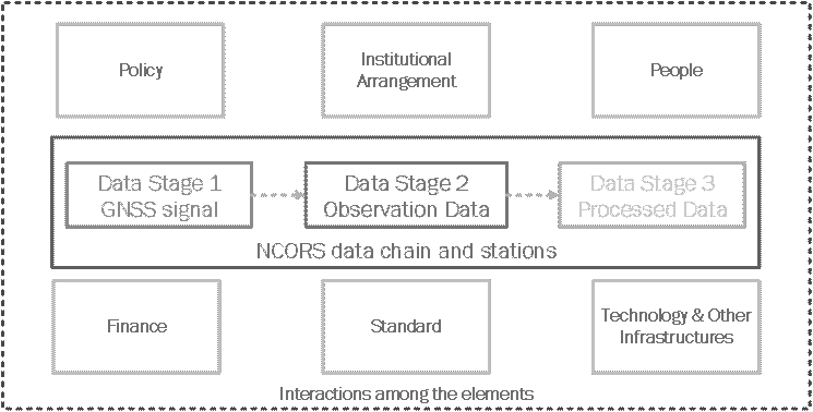
The primary functions of NCORS data support the standardisation and interoperability of spatial data at the national level. This way, it should be considered part of the National Spatial Data Infrastructure (SDI). The elementary aspect of an NCORS data ecosystem can adopt from an SDI. Van Loenen[22] explains that the core elements of SDI are 1) Data, 2) People: the actors in different sectors that require, build, use and enforce the actions for the existence of spatial data, 3) Policies: plans or courses of action to achieve the goal of the spatial data, 4) Institutional framework: the responsibility arrangement of different actors involving the spatial data, 5) Technology: the scientific method, instrument, data and material, directly and indirectly, used to enable the spatial data chain, 6) Standards: the common specification, quality, or requirements which allow the flow of spatial data between the processes and organisations, and 7) Financial resources: the interconnected resources to drive all elements.
In the NCORS data ecosystem, two main elements can be distinguished 1) the central and 2) the surrounding elements, Figure 1. An NCORS data chain and NCORS stations are the central elements. The surrounding elements are people, financial resources, institutional frameworks, technology, standards, and policies. These elements interact to facilitate the functions of the NCORS network and the flow of NCORS data from providers to users.
The NCORS data chain contains different data formats: from GNSS signals to precise positioning data. The NCORS data chain carries the data value which can be perceived in different positioning services, for example, Real-time Kinematic (RTK), Differential-GNSS (DGNSS), Precise Point Positioning (PPP), PPP-RTK, Post-Processing Kinematic (PPK), and data archive.
Mechanisms in an NCORS Data Ecosystem
The NCORS data ecosystem’s elements have a function(s) in collectively facilitating the NCORS data chain. These collective functions in an NCORS data ecosystem can be considered in three mechanisms: (1) governance, (2) provision and (3) utilisation.
The governance of NCORS data is the mechanism to govern the technical and non-technical elements with different functions to achieve the individual and the collective goal(s)[24,25]. The governance can be perceived through five aspects of SDI governance: vision, leadership and control, self-organisation ability, communication channel, and financial resource sustainability[18,26]. The governance involves the provision and the utilisation. The governance also involves external factors such as political support and facilitating conditions that significantly affect the NCORS data ecosystem.
Provision is the collective actions of the stakeholders in collecting, processing, and distributing NCORS data. The quality of the provision can be measured by the attributes of data availability[18], such as known – user awareness about the availability and user knowledge about the access to such availability; attainable – users can access and use the data; and usable – the characteristics of the NCORS data that meet user requirements. In many cases, CCORS expands the availability of overall national CORS services[27,28]. It is, therefore, part of the NCORS data ecosystem.
Utilisation is the mechanism that determines the use of NCORS data which is a critical driving force to initiate and maintain an NCORS data chain. The utilisation provides feedback to data governance and provision. It also influences governance through political and public support. The utilisation of NCORS data can be considered in many indicators, for example, the number of users or accounts, the number of downloads, the volume of downloaded data, time of use, and registered devices[27-,29]. There are benefits and drawbacks of each indicator in explaining utilisation. For instance, one user might use many devices or the other way around. This research considers NCORS data utilisation as basic utilisation – the use within original users or purposes, and optimal utilisation – the utilisation that expands beyond original users or purposes.
OPEN DATA AND NCORS
OD means the data that is made available without any technical, legal, financial, and intellectual barriers to access, use, reuse, and share the data[30,31]. The implementation of OD may affect the mechanisms in an NCORS data ecosystem (Figure 2). OD frames the data policy of NCORS governance. In terms of the provision of NCORS, OD affects the degree of NCORS data availability directly through both “known” and “attainable” attributes. Lastly,
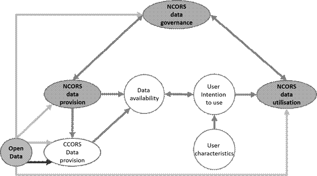
OD’s effect on data provision stimulates users to use NCORS data. This way, OD supports the utilisation mechanism in an NCORS ecosystem. Note that user characteristics also contribute to the utilisation.
METHODOLOGY
For this research, we performed a multiple case study approach[32] to investigate the effects and results of OD implementation on NCORS data ecosystems and the factors affecting the implementation. Three cases were selected based on the completeness of NCORS data availability, the availability of the national OD initiative, and the accessibility to the case data.
Desk research was conducted through papers, journals, publications and official reports to acquire the data. The analysis was conducted based on the three mechanisms of the NCORS data ecosystem. Lastly, experts from the cases were asked to review and validate the research findings and provide additional insights about the cases.
OPEN DATA AND NCORS IN DIFFERENT NATIONAL CONTEXTS
The European Union is the political and economic region where member nations have progressively implemented OD. It is also where NCORS and CCORS have been installed and operated. In 2019, the scope of the EU legal framework on open data and the Public Sector Information Directive (PSI) was broadened to real-time data. Consequently, all kinds of NCORS data have become within the scope. However, each Member State has applied OD to NCORS differently.
THE NETHERLANDS
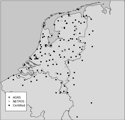
The Dutch NCORS is composed of two networks 1) “Het Actief GNSS Referentie Systeem” (AGRS.NL) – the active GNSS reference System and 2) “De Netherlands Positioning Service” (NETPOS) – the Netherlands Positioning Service. AGRS.NL maintains the Dutch spatial reference frame[34,35], authorises other GNSS networks, and supports other scientific activities[33]. NETPOS is the second-order network to densify AGRS.NL and to support public works of Kadaster, Rijkswaterstaat, research, education and innovation[34]. There are several CCORS in the Netherlands. The stations from CCORS networks can be determined and certified by AGRS.NL.
The Netherlands is one of the high-rank countries in OD implementation. The OD strategy is part of the National Data Strategy, aligning with the EU Data Strategy[35]. OD has been successfully implemented in many ministries[36].
OD on Dutch NCORS Data Governance
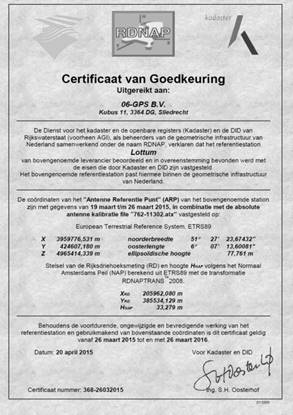
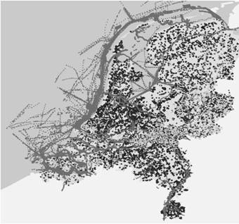
Nederlandse Samenwerking Geodetische Infrastructuur (NSGI) or the Dutch Cooperation Geodetic Infrastructure is the governing body of the NCORS networks. NSGI is a “virtual organisation based on integral management” consisting of three geodetic partners: Dutch Kadaster – horizontal reference system, Rijkswaterstaat – vertical reference system and the Hydrographic Service of the Royal Netherlands Navy – sea level[34]. NSGI facilitates NCORS networks to serve public activities and standardise the positioning services of other CORS networks using the common geospatial reference frame. NSGI assigns the Dutch Kadaster to certify stations of the NCORS and CCORS[37] over the Netherlands and in the neighbouring countries, Figure 3.
OD is mentioned in the NSGI multi-year plan 2021-2025[34]. However, NCORS stakeholders share diverse opinions and intentions toward OD-NCORS. An expert of the NCORS provider support OD-NCORS. Since NCORS data are public data, citizens should use them without paying. Meanwhile, a CCORS manager expressed a concern that OD NCORS might affect their market.
The conditions above may presumably contribute to the decree on further release of raw GNSS data in a file format (Besluit verdere vrijgave van ruwe GNSS-data in bestandsvorm)[38]. Only RINEX has been open since September 7th 2019[39]. Nevertheless, NSGI seeks to apply OD-NCORS for scientific and primary geodetic tasks[34].
OD on Dutch NCORS Data Provision
NCORS data in the Netherlands is available nationwide. In combing with CCORS, the availability of positioning data can support the use in low-to-high positioning accuracy for any geospatial data activities. OD-NCORS appears only on RINEX from NETPOS[39]. One informant reported that this implementation is to prevent the overlapping of the RTK service of the CCORS. However, the provision of CCORS relies on NCORS since CCORS stations are certified by NCORS.
OD on Dutch NCORS Data Utilisation
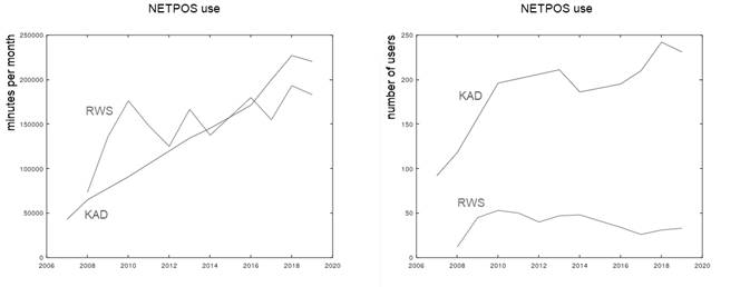
OD slightly affects the utilisation of NCORS since it applies only to RINEX data. The Dutch NCORS benefits scientific works, survey and mapping, engineering, navigation and meteorological purposes on national and international scales. Government agencies and academics have been the primary users. According to an expert from NSGI, most users access the data through the Delft University of Technology, the Reference Frame Sub-Commission for Europe (EUREF) and the International GNSS Service (IGS) that stream and share data from some stations. The RTK and PPK mainly were used for cadastral survey and mapping of Kadaster, construction works of Rijkswaterstaat and other government activities, Figures 4 and 5. In addition to the positioning services, NSGI sets a goal of NETPOS “to act as the control service for GNSS product certification”[34].
The availability of CCORS should imply CORS data use beyond NCORS. A CCORS provider explained that a few commercial providers initially serviced RTK in the early 2000s. At that time, some government agencies were also the users of CCORS. Agriculture has been a large sector of CORS data use in the Netherlands since 2010. Half of the Dutch farmers use RTK from the CCORS. NCORS data use in the commercial market is seen through CCORS certified and standardised on the reference frame by the NCORS.
GERMANY
Satellitenpositionierungsdienst der Deutschen Landesvermessung, known as SAPOS is the NCORS network operated by Germany’s federal and state governments (Laender). The network was established in 1994 as a prototype and started to service nationwide in 2003[40] with around 270 stations[41]. The Working Committee of the Surveying Authorities of the Laender of the Federal Republic of Germany (AdV) is the SAPOS governing body. The geospatial related authorities in the federal governments and several authorities in the state governments participate in AdV. SAPOS in the states is networked into the national public network and controlled by the Central Office SAPOS (ZSS). CCORS networks are available in Germany.
The OD policy has been part of the national E-government act passed by the parliament in May 2017. PSI initiative was adopted into the Act on the Reuse of Public Sector Information, the Information Re-Use Act (IWG)[40]. In February 2021, the federal government adopted the second Open Data Act and a Data Use Act (DNG) to extensively expand the availability of open administrative data and improve the possibilities for using publicly financed OD. The OD strategy was formed with stakeholder involvement[35]. For example, data providers and users contributed to selecting high-value datasets at the national level.
OD on SAPOS Data Governance
Since 2014, the OD initiative has contributed to the vision of AdV and SAPOS accordingly. The vision covered the digitisation of administrative procedures to serve e-government and the ‘stakeholders’ transparency, participation, and cooperation. In the part of AdV, SAPOS shall ensure highly accurate and uniform correction data services in Germany’s official three-dimensional reference system (ETRS89 / DREF91)[42-43].
OD has an impact on SAPOS data policy and financial resources. Before the national OD campaign in 2017, SAPOS generated revenue through the data services based on the AdV guideline of the fees for providing and using geospatial base data[44]. Implementing an OD policy has been at the state with different contexts and approaches. Most states can implement OD on their SAPOS. According to an expert, the OD policy impacts the CCORS market – the public sector competes with the private sector. Compensation has been one of the solutions for such an impact. One example is that a state authority leaves GNSS machine calibration services to the CCORS providers in exchange for OD on SAPOS.
OD on SAPOS Data Provision
SAPOS provides 1) Real-Time Positioning Service (EPS) with decimetre accuracy, 2) High Precision Real-Time Positioning Service (HEPS) with centimetre accuracy, and 3) Geodetic Precision Positioning Service (GPPS) with millimetre accuracy level[45-46]. AdV seeks to employ PPP-RTK as a SAPOS positioning service[47].
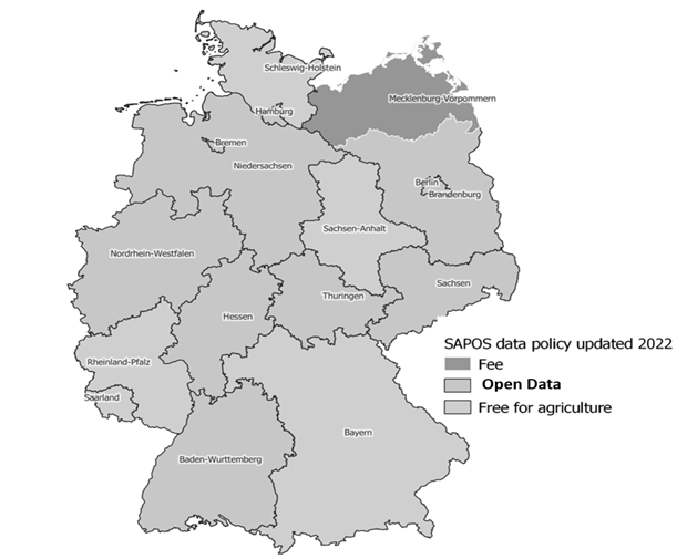
OD has been fully implemented in some states (Figure 6). For example, in North Rhine Wespalean[46], Für Niedersachsen und Bremen[48], and Berlin. Hamburg and Schleswig-Holstein will implement OD in 2022 to support the digital strategy[49]. Some states apply OD for only agriculture. Mecklenburg-Western Pomerania does not implement OD but provides a cost exemption for the public transport authorities and other mutual exchanges.
OD on SAPOS Data Utilisation
OD on SAPOS is seen at the state level. An example of an OD state-wide impact is North-Rhine Westphalia (Figure 7). The number of new SAPOS users increased drastically after implementing OD[50]. The growth of user volume also expanded in agriculture[51]. Nonetheless, the SAPOS data benefit many sectors[40].
SWEDEN
The Swedish public CORS network is SWEPOS™ (ett Svenskt nätverk av fasta referensstationer) established in early 1990s for scientific and public works. In 1992, there was an initiative to utilise SWEPOS for other domains. Later, pilot Network-RTK projects were carried out in many areas[52] together with the densification of SWEPOS to support RTK and other positioning applications in many domains.
Lantmäteriet (the Swedish mapping, cadastral and land registration authority), the leading organisation of SWEPOS, classifies two SWEPOS stations: Class A and B. Class A consists of 21 stations that function in the national spatial reference frame (SWEREF 99). Class B stations are installed to densify and expand the service coverage. Class B stations are accounted for 90% of the SWEPOS. There are other CCORS networks in Sweden[53].
According to Open Data Maturity Report 2021[35], several OD policies have been implemented in Sweden, such as the national principles for ‘Open by ‘Default’ by the Agency for Digital Government (DIGG), the European Interoperability Framework (EIF), and the adoption of the PSI directive. The Swedish Fundamental Law also states in the principle of public access that “official information is available for reuse”. However, the availability of financial resources is a challenge in implementing OD since many public organisations are financed by the revenues from the data they provide. The solution for such issues is politically sensitive and had to reach a verdict in the Swedish parliament[35].
OD on SWEPOS Data Governance
Some SWEPOS settings affect the OD on SWEPOS. Lantmäteriet’s geodetic activities 2011 2020 plan states that “to meet Swedish society’s needs for a homogeneous, sustainable national geodetic infrastructure and guarantee its availability and use”[54]. Such a vision guides the goal of SWEPOS to genuinely serve society through national positioning services by coordinating with any stakeholders in public and private sectors and international. Densification of the CORS network nationwide is a goal of the SWEPOS[54]. SWEPOS is funded by the government and revenue from data and services. SWEPOS establishment costs are covered by governmental funding. The maintenance, operation and future upgrades costs are covered by the user subscription fees[55]. These settings frame the implementation of OD on SWEPOS. Under the Act on Reuse of Public Administration Documents (2010: 566) and the revision in 2019, the Swedish authorities must publish a government’s open data list. Lantmäteriet was assigned to define the valuable datasets that should be made available according to the new OD directive (EU Directive 2019/1024). Even though SWEPOS data were proposed as high-value data[56], OD has not been fully implemented for SWEPOS data.
OD on SWEPOS Data Provision
OD has some extent to the provision of SWEPOS data that are available in the whole of Sweden and along the border with the data exchange collaboration with other Nordic countries[57]. SWEPOS data have been under OD, for instance, DGNSS and RINEX, since 2016[57]. However, the use of RTK is charged. CCORS providers also stream, process and redistribute SWEPOS data to their customers against fees[29]. The data cooperation with CCORS is to increase the use of SWEPOS data[58]. An expert viewed that the availability of CCORS is necessary to ensure nationwide positioning services, which benefits users in society.
OD on SWEPOS Data Utilisation
The utilisation of SWEPOS data is in many activities, Figure 8. The total use of SWEPOS in all sectors has been exponentially increased since 2003. Note that there were already 200 users at the beginning of SWEPOS RTK in 2004[29]. Jensen[59] found three main areas of use; 71% in building and construction, 15% in farming and 4% in other activities. Between 2013 and 2018, the use in farming and construction significantly increased from 5% to 15% and 22% to 25%, respectively. It can be said that without full OD implementation, the utilisation of SWEPOS is already significant.
DISCUSSION
THE IMPACT OF OD ON THE NCORS DATA ECOSYSTEMS
NCORS data governance is affected by OD. The governance faces a role in dealing with the factors that affect the internal mechanisms of the NCORS data ecosystem, for example, the private sector, political support, financial resources, regulations, and national visions.
In Sweden, OD has been implemented on NCORS alongside the goal of national positioning services. In this way, the charge in some data as the financial support for NCORS and the cooperative competition with CCORS are maintained. In the Netherlands, the implementation of OD has been in conflict with the interests of CCORS. However, the interpretation of the law and the political support preserve the CCORS interest by preventing NCORS from being a competitor. Further relations between NCORS and CCORS are in the standardisation of the services where NCORS certifies CCORS. In Germany, the negotiation between the states and CCORS resulted in the OD-NCORS in most states. A state bartered OD implementation by offering a GNSS equipment calibration service for a CCORS provider.
NCORS data provision is affected by OD through the governance. The perception of CCORS affects the implementation of OD on the NCORS data provision. OD improves the attainability of NCORS data. However, this is not the case for Sweden, where national positioning services are considered on the availability of NCORS and CCORS. OD is applied on only RINEX and DGNSS, which seem not to be the markets of CCORS. In the Netherlands, the RINEX data is free of charge. In Germany, most states adopt OD to NCORS data. The nationwide services are still charged.
NCORS data use, the data use in all cases is considerable. However, all three cases provided an unclear explanation of whether OD impacts NCORS data use. Comparable NCORS data use numbers were found despite different levels of OD implementation.
In the Netherlands, the cost of use in CCORS implies that some users are willing to pay for the services. In Sweden, the use of NCORS is still considerable in many fields. In Germany, the surge in use after OD in the NRW can result from new users starting to use precise positioning services or the mobilisation of users from CCORS to NCORS. Therefore, implementing OD NCORS might not be the most critical factor in using NCORS data. The impacts of OD-NCORS are in Table 1.
THE FACTORS SHAPING OD-NCORS IMPLEMENTATION
We can conclude that the factors contributing to OD-NCORS implementation are 1) the national governing nature and 2) the non-government actors.
Firstly, the national governing nature frames how NCORS governing entities adopt OD. The factor is visible in the national visions and the governing structures in executing them to reach such vision. The three cases share a similar national vision and political awareness in OD. However, the government in charge of NCORS determine the extent of OD implementation. The NCORS governing structures in the Netherlands and Sweden are under the central government. In Germany, the state governments are the governing body to implement OD according to the national strategy. The adoption of OD on NCORS differs among the states due to their contexts.
Secondly, the availability of actors beyond the public sector frames OD-NCORS implementation. The three cases showed different perspectives on the availability of CCORS which affect how OD implements and how NCORS networks position themselves with CCORS. Several interpretations of OD and NCORS might affect OD-NCORS. The Netherlands holds that OD should not affect third parties’ interests – i.e., the interests of CCORS providers. Therefore, OD is only applied to the NCORS data that are not competing with CCORS data. CCORS, as an element of a national positioning service, results in a cooperative competition between CCORS and NCORS in Sweden. In Germany, the states adopted their approaches to dealing with CCORS.
IMPLICATIONS
Theoretical implications in this study are found in the comprehension of a data ecosystem through the lens of NCORS data. A data ecosystem is part of the larger ecosystem – a system of systems. The data ecosystem interrelates with other ecosystems, such as business ecosystems and technology ecosystems. Therefore, data governance should be highlighted for the interactions with other elements in other ecosystems. As suggested in SDI, communication channels are essential in gaining political and public support[26].
Measuring data use was still a challenge. The different ways to measure data use can be the number of requests, hits, views, transformation, citations, and the number of users[60-62]. These indicators are applicable for the direct use of NCORS data. However, NCORS data use can be perceived in other ways, as seen in the cases. Data from some NCORS stations are used with CCORS data to provide positioning services, as seen in Sweden. CCORS might be processed or calibrated on the national framework provided by NCORS data, as seen in the Netherlands. These ways of use may imply the necessity for defining NCORS data and other data utilisation.
Practical implications are seen in many aspects. First, the governing body needs to understand the settings of each data and its ecosystem. OD has both positive and negative effects on data availability. Without a clear understanding of the impact of OD on NCORS, the OD implementation might harm the data ecosystem itself.
Second, the practical implications might be a lesson for other data with different stakeholders with diverse perspectives. The role of data governance should follow the so-called informally governance to keep all stakeholders in the loop. The outcome might compromise some initiatives. Still, the compromising must rely on users, the key actors in the utilisation.
Third, the findings imply that user characteristics can be more critical than the data policy in the successful implementation of OD-NCROS. The history of use of the three cases implies the user characteristics: their technical skills, perception about the use, financial capability, and the necessity of use. In the cases, users were capable of using, and it was necessary for them to use despite the relevant costs. Therefore, any OD approaches result in the considerable use of NCORS data. In practice, policymakers should consider user characteristics as part of OD implementation.
CONCLUSIONS AND RECOMMENDATIONS
This article has applied an NCORS data ecosystem concept to explore Open Data implementation in National Continuously Operating Reference Station Networks (NCORS) in three Member States of the European Union. OD has positive and negative impacts on the NCORS data ecosystem. The common benefit is the availability of data for users. However, OD-NCORS may negatively impact the availability of commercial CORS (CCORS). The national governing nature and CCORS availability shape the OD implementation. Overall, we can conclude that no single approach for OD-NCORS implementation fits every national context. The countries must face the challenges by compromising both the goals of NCORS and OD in a sustainable manner.
This study pertains to limitations on the data to indicate the volume of use from the private sector. Besides, the data ecosystem conception in this study still has a gap in defining data utilisation. Future research is encouraged to apply the NCORS data ecosystem concept to explore NCORS in other contexts where the NCORS elements and mechanisms are not perfectly functioning. The application may provide insights to improve the NCORS data ecosystem conception. The data utilisation defined in this research can be further investigated in terms of the impact to provide a complete picture of data utilisation.