License (open-access, http://creativecommons.org/licenses/by-sa/4.0/):
CC-BY-SA
License (open-access):
Prava korištenja: CC-BY-SA
License (open-access):
Journal content is published under CC-BY-SA licence.
Publication date: 2020
Volume: 19
Issue: 33
Book review
Centuriation of Continental Part of Iader (Zadar) Roman Colony Ager Roman cadastre
Marijan Kadi
This overview describes the extension to the research of Roman centuriation of Iader (Zadar) ager,
which is related to the continental part of ager. My previous research encompassed the insular part of the ancient ager of Zadar, the Island of Ugljan (Kadi 2016, 2019).
centuriation; Roman cadastre; Iader colony
243431
30.6.2020.
Visits: 3.635 *
Bradford M (1947) A Technique for the Study of Centuriation. Antiquity, 21, 84, 197-204. https://doi.org/https://doi.org/10.1017/S0003598X00016689https://www.cambridge.org/core/journals/antiquity/article/abs/technique-for-the-study-of-centuriation/F37B788B521BA0836CB03657D8FB39B5
Kadi M (2019) Centurijacija otoka Ugljana, Nastavak istraživanja / The Centuriation of the Island of Ugljan, Continuation of Research. Kartografija i geoinformacije, 18, 31, 97-107. https://doi.org/https://doi.org/10.32909/kghttps://hrcak.srce.hr/en/222073
Maršić D (1992/1993) Prilog poznavanju limitacije agera antičkog Zadra. Radovi Filozofskog fakulteta u Zadru, Razdio povijesnih znanosti, 32, 19, 105-116. https://doi.org/https://doi.org/10.15291/radovipov.2277
This overview describes the extension to the research of Roman centuriation of Iader (Zadar) ager, which is related to the continental part of ager. My previous research encompassed the insular part of the ancient ager of Zadar, the Island of Ugljan (Kadi 2016,2019).
Surveying the Iader (Zadar) colony according to Roman agrarian regulation started during the rule of Augustus (27 B.C. – 14 A.D.) (Suić 1955). The resulting grid of centuriae forms a rectangular coordinate system. Two perpendicular axes passed through the center of the system. They are cardo maximus (CM) and decumanus maximus (DM). One centuria with the size of 710 m × 710 m has an area of 50.41 ha and is divided into 100 herediae. One heredia with the size of 71 m × 71 m has an area of 0.50 ha and is divided into two jugers. One juger with the size of 35.5 m × 71.0 m has an area of 0.25 ha. I wrote more about Roman cadastre in the book Centuriation of the Island of Ugljan – Roman Cadastre (Kadi 2016).
The first person to study the ancient ager of Zadar was English archaeologistJ. P. Bradford (1947), who used aerial images from World War II. The Zadar ager was subsequently studied by Suić (1955,1960,1976). According to him, the ager stretched from Puntamika to Bibinje, and to the settlement Crno toward Zadar hinterland, which encompasses 50 centuriae.Maršić (1992) attempted to prove that Zadar ager did not end at Bibinje, but that it encompasses a significantly larger area, which covers a part of the Zadar hinterland. Priest and historianFilipi (1960) studied the problem of limitation of the northwestern part of the Island of Ugljan, where he discovered six cardos and three decumani. I also studied centuration on the entire Island of Ugljan and discovered 67 centuriae (Kadi 2016,2019).
I used a map in the scale of 1:100 000 to scout the continental part of the ancient Zadar ager. The map shows the assumed project of Roman centuriation with a division into centuriae. The operation is bounded by Puntamika in the northwest to Sukošan in the southeast, and to Poličnik in the northeast. The cardo maximus (CM) and decumanus maximus (DM) divide the area into four quadrants. Each quadrant contains an equal number of centuriae, 81. There are 324 centuriae in total. The origin of the coordinate system (umbilicus) is approximately 1000 m southwest of settlement Višići. The importance of knowing positions and numbers of centuriae lies in it enabling one to study the agrarian economic power of particular settlements and the number of colonists in the ager. If we accept that the number of residents in the Pula and Poreč agers in the 1st and 2nd centuries was 35 people on one centuria (Matijašić 1988), and the quality of arable land is equal to that on the Zadar ager, then the number of residents in the 284 centuriae covered in this short paper would be 9940, without residents of Zadar. By producing the Roman cadastre, Roman surveyors (agrimensors) contributed to remaking the environment and improving the basic economic activity – agriculture. After surveying and assigning parcels, a document was produced about limitation of ager in the form of a map with ownership data. One copy of the surveying plan was stored in Tabularium in Rome, while the other two copies remained in the colony as a cadastral document for recording changes (Suić 1955: 7).
This paper on studying the ancient Zadar ager would have yielded even better results if plans and maps of the Zadar hinterland had been available: Venetian Cadastre (17th and 18th centuries), Austrian Cadastre (1818–1839), aerial images and opportunity of doing field research.
I exclusively used the Croatian Base Map (Hrvatska osnovna karta – HOK) in the scale of 1:5000 as the basis of research. The map provides an objective and meaningful image of space with all necessary information for further analysis. Twenty-nine sheets of HOK contain paths, streets, roads, drywall parcel border lines, settlements, churches and other details which refer to discovering centuriation. These sheets of HOK show that spatial development of the continental part of Zadar and settlements Crno, Murvica and Poličnik evolved along paths which define centuriation lines, and which cover centuriation lines in certain places. The main road which connects settlements Poličnik and Murvica with Zadar is parallel with a centuriation line which is six centuriae long (4260 m). A part of the border between cadastral municipality Poličnik and cadastral municipality Murvica matches in length of 1420 m within two centuriae.
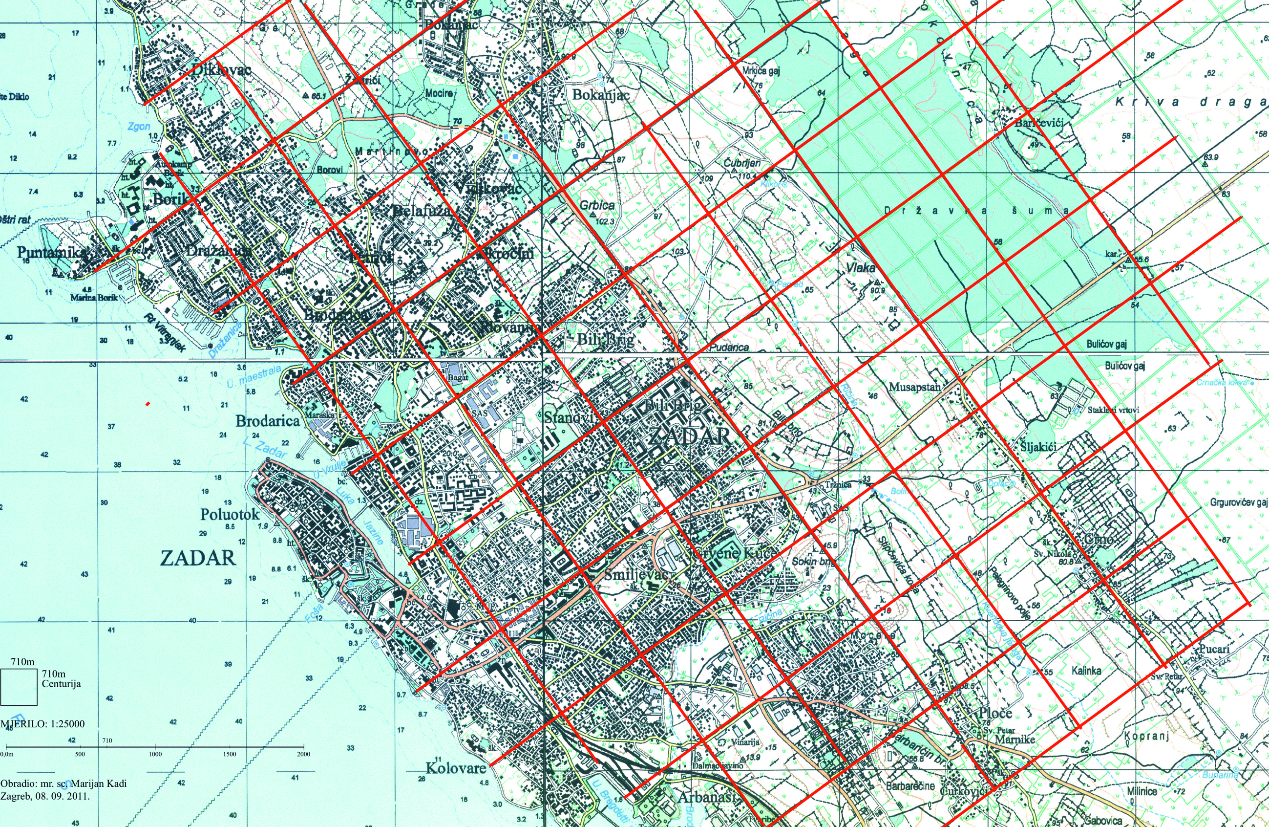
Some present streets in Zadar match the borders of ancient Zadar. They are the following streets: A. G. Matoša, Put kotarskih Serdara, Nikole Tesle, Put Plovanje, Put Biliga, Splitska, Ivana Rendića, Kneza Nikole Krbavskog, Matije Vlašića, S. Batušića i F. Krežme, Filipa Lukasa, Gaženička, F. Tuđmana, a part of V. Mačeka, Domovinskog rata, M. Getaldića, Gaženička cesta, admirala J. Šubića od Cezana, Bihaćka, Josipa Hatzea, Iva Dulčića, Nikole Jurišića and Hrvatski Sabor. The topographic map 1: 25 000 inFigure 1 shows the centuriation of Zadar ager in the wider area of the city. Red lines indicate Roman paths as border lines (limes) between centuriae.
Knowledge about the match between present streets of Zadar with limits of ancient Zadar, as well as other details of the discovered centuriation, represent a contribution to the study of spatial development of Zadar and its hinterland.
After World War I and World War II, Zadar’s hinterland was afforested and some forest aisles formed table with the size of one centuria (710 m × 710 m). A deflection of 1º30' toward northeast from the centuriation line was observed between centuriation raster of ancient Zadar and existing forest aisles. We can assume the Roman division was noticed during planning the forest aisles, i.e. paths which represent centuration limits and that the intention was to renovate parcellation according to Roman cadastre and retain the size of the Roman parcel. The orientation error was probably made during pegging out.
Even though the sheets of the topographic map representing this area contain nothing else then forests that could indicate potential centuriation, the position of forest aisles still points to someone partially discovering the centuriation grid and attempting to reconstruct it using forest aisles.
The orthophotomap encompassing the area between Murvica and Smoković clearly shows divisions into centuriae indicated in red and divisions into herediae in blue. The main path through the settlement follows the orientation of the Roman division.
A representation of the present cadastre on an orthophoto base was produced for the same area between Murvica and Smoković. At a glance, the diversity of orientations of individual parcels does not point to the existence of the Roman cadastre. However, after thorough research we can partially detect and reconstruct lines of centuriae and herediae which match border lines of parcels and paths.
Position of churches on maps contributed to discovering the grid of the Roman cadastre. Churches were built by existing paths, which often represented border lines (limes) of centuriae. The following churches were built by border lines of centuriae: church of St. Joseph in Zadar, St. Nicholas in Crno, St. Peter (in the cemetery) in Crno, St. Mary in Briševo, St. John (in the cemetery), St. Nicholas in Poličnik and St. Simon and Thaddeus in Bokanjac. The following churches were built on herediae division lines: the Assumption of Mary in Dračevac Zadarski, the Assumption of Mary in Bibinje and St. Georgia in Smoković.
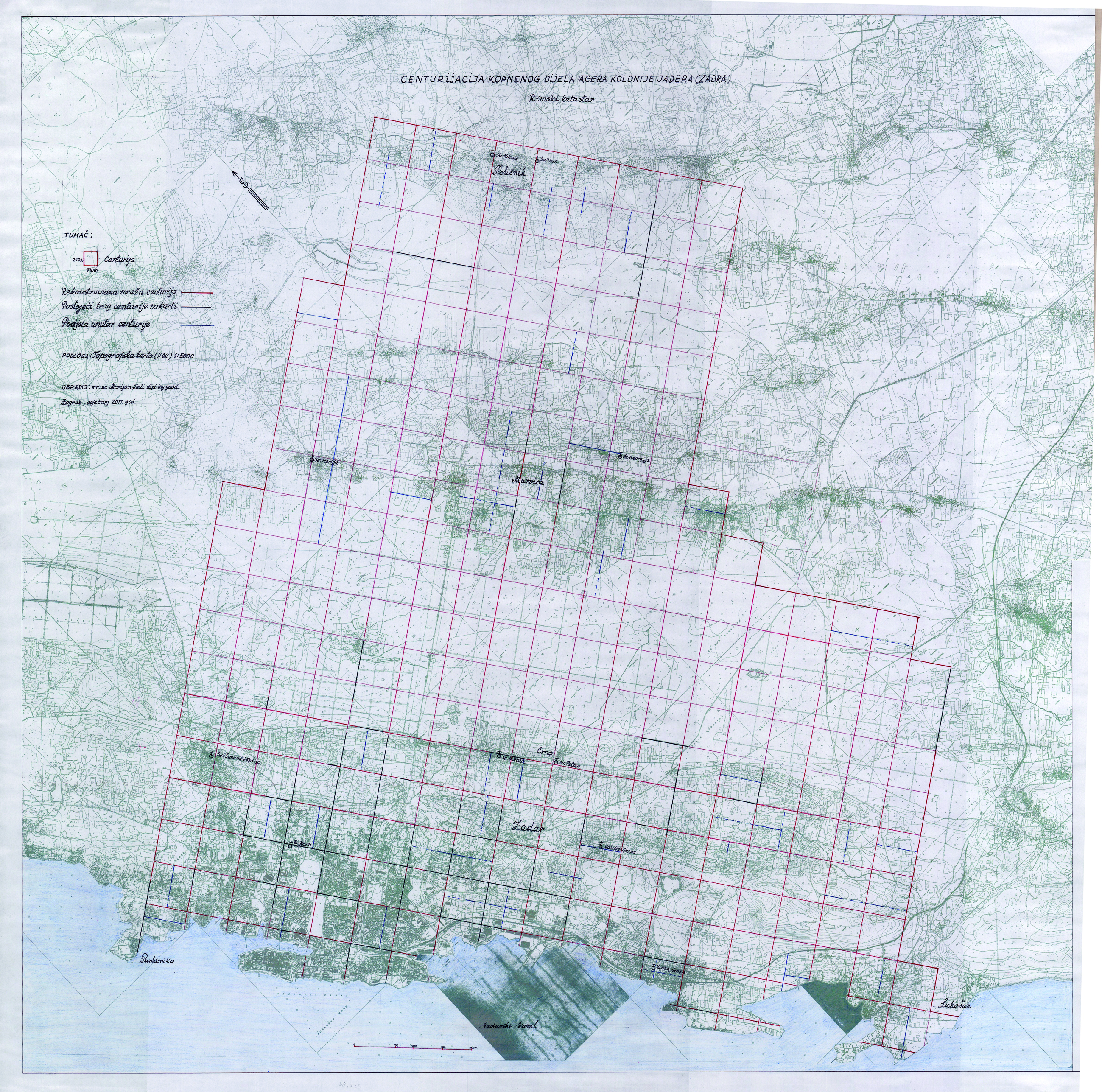
The reconstructed centuriae grid is indicated in red on the topographic map in the scale of 1:10 000 (produced by connecting 29 sheets of HOK). The size of the map is 1.50 m × 1.60 m, and a reduced image is shown onFigure 2. Lines of parcels, paths and drywall which match the centuriation are indicated in black, while the division of centuriae into herediae is indicated in blue. The represented centuriae grid on the map is deflected from the geographic north by 50º. The represented number of centuriae on the map is 284 (14316 ha).
Ovaj prikaz opisuje nastavak istraživanja rimske centurijacije jadertinskog (zadarskog agera), a odnosi se na kopneni dio agera. Moje prethodno istraživanje obuhvaćalo je otočni dio antičkog agera Zadra, otok Ugljan (Kadi 2016,2019).
Izmjera kolonije Jadera (Zadar) započeta je prema rimskim agrarnim propisima za vladavine Oktavijana Augusta (27. god. pr. Kr. – 14. god. poslije Kr.) (Suić 1955). Nastala mreža centurija tvori pravokutni koordinatni sustav. Središtem sustava prolazile su dvije osi okomito jedna na drugu. To su cardo maximus (CM) i decumanus maximus (DM). Jedna centurija veličine 710 m × 710 m ima površinu 50,41 ha i dijeli se na 100 heredija. Jedan herdij veličine 71 m × 71 m ima površinu 0,50 ha i dijeli se na dva jugera. Jedan juger veličine 35,5 m × 71,0 m ima površinu 0,25 ha. Više o rimskom katastru pisao sam u knjizi Centurijacija otoka Ugljana – rimski katastar (Kadi 2016).
Prvi istraživač antičkog agera Zadra bio je engleski arheologJ. P. Bradford (1947) koji se koristio avionskim snimkama iz II. svjetskog rata. Nakon njega zadarskim se agerom bavio Suić (1955,1960,1976). Po njemu ager se prostirao od Puntamike do Bibinja, a prema zaleđu Zadra do naselja Crno, što obuhvaća 50 centurija.Maršić (1992) je pokušao dokazati da zadarski ager ne završava ispred Bibinja nego zahvaća znatno veći prostor koji obuhvaća i dio zadarskog zaobalja. Svećenik i povjesničarFilipi (1960) bavio se problemom limitacije sjeverozapadnog dijela otoka Ugljana gdje je otkrio šest karda i tri dekumana. Istraživanjem centurijacije na cijelom otoku Ugljanu bavio sam se i ja i pritom otkrio 67 centurija (Kadi 2016,2019).
Za rekognosciranje kopnenog dijela antičkog agera Zadra poslužila mi je karta u mjerilu 1:100 000. Na toj karti prikazan je pretpostavljeni projekt zahvata rimske centurijacije sa podjelom na centurije. Granica zahvata ide od Puntamike na sjeverozapadu do Sukošana na jugoistoku, a na sjeveroistoku do Poličnika. Glavni kardo (CM) i glavni dekumanus (DM) dijele zahvaćeno područje na četiri kvadranta. Svaki kvadrant sadrži jednaki broj centurija, 81. Ukupno je riječ o 324 centurije. Ishodišna točka tog koordinatnog sustava (umbilicus) nalazi se oko 1000 m jugozapadno od naselja Višići. Važnost poznavanja položaja i broja centurija je u tome što pruža mogućnost detaljnog proučavanja agrarno ekonomske moći pojedinih naselja te broj kolonista u ageru. Ako prihvatimo da je na puljskom i porečkom ageru broj stanovnika u I. i II. st. na jednu centuriju bio 35 osoba (Matijašić 1988), a kvaliteta obradive zemlje podjednaka onoj na zadarskom ageru, tada bi broj stanovnika na 284 centurije prikazane u ovom radu iznosio 9940 bez stanovnika grada Zadra. Rimski mjernici (agrimensori) izradom rimskoga katastra pridonijeli su preoblikovanju okoliša i unapređenju osnovne gospodarske djelatnosti – poljoprivrede. Nakon izmjere zemljišta i dodjele parcela sastavljao se dokument o limitaciji agera u obliku mape u koju su se unosili podatci o vlasništvu. Jedan primjerak plana izmjere zemljišta pohranjivao se u Tabularijumu u Rimu, a dva su ostala u koloniji kao katastarski dokument za unos promjena (Suić 1955: 7).
Ovaj rad na istraživanju antičkog agera Zadra dao bi još bolje rezultate da sam imao na raspolaganju planove i karte za područje zadarskog zaleđa: Mletački katastar (17 i 18 st.), Austrijski katastar (1818–1839), avionske snimke i mogućnost terenskog istraživanja.
Kao podloga za detaljno istraživanje poslužila mi je isključivo Hrvatska osnovna karta (HOK) u mjerilu 1:5000 koja daje objektivnu i sadržajnu sliku prostora sa svim neophodnim informacijama za daljnju obradu. Na 29 listova HOK-a istražene su staze, putevi, ulice, ceste, međne linije parcela ograđenih suhozidom, naselja, crkve i ostali detalji koji upućuju na otkrivanje centurijacije. Na tim listovima HOK-a možemo uočiti da se prostorni razvoj kopnenoga dijela Zadra te naselja Crno, Murvica i Poličnik razvijao uzduž puteva koji definiraju linije centurijacije, a na pojedinim mjestima se poklapaju s linijama centurija. Glavna cesta koja spaja naselja Poličnik i Murvicu sa Zadrom paralelna je s linijom centurijacije duljine 6 centurija (4260 m). Dio granice između K.o. Poličnik i K.o. Murvica poklapa se unutar dviju centurija u duljini od 1420 m.
Neke od današnjih ulica grada Zadra poklapaju se s limesima antičkoga Zadra. To su sljedeće ulice: A. G. Matoša, Put kotarskih Serdara, Nikole Tesle, Put Plovanje, Put Biliga, Splitska, Ivana Rendića, Kneza Nikole Krbavskog, Matije Vlašića, S. Batušića i F. Krežme, Filipa Lukasa, Gaženička, F. Tuđmana, dio V. Mačeka, Domovinskog rata, M. Getaldića, Gaženička cesta, admirala J. Šubića od Cezana, Bihaćka, Josipa Hatzea, Iva Dulčića, Nikole Jurišića i Hrvatski Sabor. Na topografskoj karti 1: 25 000 (slika 1) prokazana je centurijacija zadarskog agera na širem području grada. Crvenim linijama prikazani su rimski putovi kao granične linije (limesi) između centurija.
Spoznaja o preklapanju današnjih ulica grada Zadra s limesima antičkog Zadra, kao i drugih detalja otkrivene centurijacije, doprinos su u istraživanju prostornog razvoja Zadra i njegova zaleđa.
Nakon I. i II. svjetskog rata zadarsko zaleđe je pošumljavano pri čemu su ponegdje šumske prosjeke formirale table veličine jedne centurije (710 m × 710 m). Između rastera centurijacije antičkog Zadra i postojećih šumskih prosjeka uočen je otklon od 1º30' prema sjeveroistoku od linija centurijacije. Možemo pretpostaviti da je prigodom projektiranja šumskih prosjeka uočena rimska podjela, tj. putevi koji predstavljaju limese centurijacije i da se željelo obnoviti parcelaciju prema rimskom rasteru te zadržati dimenzije rimske parcele. Pri izvođenju iskolčenja prosjeka došlo je vjerojatno do te greške u orijentaciji.
Kako na listovima topografske karte koji prikazuju to područje osim šuma nema drugog sadržaja koji bi naznačio moguću centurijaciju, ipak nas položaj šumskih prosjeka upućuje na to da je netko djelomično otkrio mrežu centurijacije i pokušao je rekonstruirati preko šumskih prosjeka.
Na primjeru ortofotokarte koja obuhvaća područje između Murvica i Smokovića mogu se jasno uočiti podjele na centurije označene crvenom bojom i unutar centurije na heredije označene plavom bojom. Glavni put kroz naselje prati orijentaciju rimske podjele.
Na istom području između Murvica i Smokovića izrađen je prikaz današnjeg katastra na ortofoto podlozi. Na prvi pogled raznolikost u orijentaciji pojedinih parcela ne ukazuje na postojanje rimskog katastra. Međutim, nakon temeljitog istraživanja možemo djelomično otkriti i rekonstruirati linije centurija i heredija koje se poklapaju s međnim linijama parcela i putova.
Položaj crkvi na kartama pridonio je otkrivanju mreže rimskog katastra. Crkve su građene uz postojeće puteve koji su često predstavljali granice centurije (limese). Crkve koje se nalaze uz linije podjele na centurije su: crkva sv. Josipa u Zadru, sv. Nikole u Crnom, sv. Petra (na groblju) u Crnom, sv. Marije u Briševu, sv. Ivana (na groblju), sv. Nikole u Poličniku i crkva sv. Šimuna i Tadije u Bokanjcu. Crkve koje se nalaze na liniji podjele na heredije su: Velika Gospa u Dračevcu Zadarskom, Velika Gospa u Bibinju i sv. Georgija u Smokoviću.
Rekonstruirana mreža centurija prikazana je na topografskoj karti u mjerilu 1:10 000 (nastala spajanjem 29 listova HOK), i označena je crvenim linijama. Dimenzije karte su 1,50 m × 1,60 m, a smanjen prikaz je naslici 2. Linije parcela, puteva i suhozida koje se poklapaju s centurijacijom označene su crnom bojom, a podjela unutar pojedinih centurija na heredije plavom bojom. Prikazana mreža centurija na karti ima otklon od geografskog sjevera prema zapadu 50º. Prikazani broj centurija na karti je 284 (14316 ha).