Skoči na glavni sadržaj

Izvorni znanstveni članak

https://doi.org/10.7906/indecs.20.3.2

Drone Component for Radio Frequency Detection

Péter Miksa Hell orcid id orcid.org/0000-0002-4964-7249 ; Óbuda University, Doctoral School on Safety and Security Sciences Budapest, Hungary
Péter János Varga orcid id orcid.org/0000-0002-4964-7249 ; Óbuda University, Doctoral School on Safety and Security Sciences Budapest, Hungary


Puni tekst: engleski pdf 974 Kb

str. 230-238

preuzimanja: 113

citiraj

Preuzmi JATS datoteku


Sažetak

Recovering people who have lost their way during a hike or disappeared during a disaster is a significant task for disaster management agencies. Nowadays, there are numerous technological devices at our disposal in such cases. Night-vision devices, thermal imagers, and drones are among such technologies. Time is a critical factor in a disaster situation, so by deploying drones, a greater area can be inspected in a given time. These types of general-purpose aircraft are primarily equipped with visual reconnaissance components, such as high-resolution or infrared cameras. The disadvantage of these devices is that they only work effectively in open terrains with adequate visibility conditions. If the missing person is in a dense forest or in a covered space, the chances of recovery decrease significantly.
Our development is a radio-frequency detector drone component, which can find the mobile device of the person in trouble, and therefore eliminates the prerequisite for adequate visual conditions. This enables greater efficiency in the case of recovery efforts.

Ključne riječi

drone; communication; disaster; radio; detection; component

Hrčak ID:

278780

URI

https://hrcak.srce.hr/278780

Datum izdavanja:

1.6.2022.

Posjeta: 318 *


INTRODUCTION

Disaster management agencies use drones for carrying out special tasks on a daily basis. Their usefulness is undeniable. These aircraft have been one of the most important tools for assisting disaster management in recent years1. By using drones, not only can we shorten the time it takes to complete tasks, but we can also look at events from a perspective that we cannot obtain from ground level at all. With the help of well-known drone components – such as a camera or a thermal camera – we can transfer images/videos to the drone pilot. This information helps and speeds up decision-making on relief tasks. There may be cases in which the examined area is covered. This means the camera is no longer able to detect objects and people trapped under the covered area. During disasters and accidents, the primary goal is to save human life. Therefore, time is the primary factor. Our goal was to develop a drone component that, in addition to visual information, also supports rescue efforts with radiofrequency data.

DISASTER MANAGEMENT AND THE POSSIBILITIES OF USING A RADIO FREQUENCY DRONE COMPONENT

Drones currently used in disaster management perform the following tasks: • search and rescue tasks, • firefighting tasks, • law enforcement, prevention, and policing, • prevention of natural and industrial disasters. During search and rescue missions, disaster management agencies have to save lives in different terrain conditions. Drones with visual observation components can identify the human shape from a distance of up to tens of meters. With the help of a thermal camera, it can detect an organism with a different temperature than its surroundings even if it’s under a thinner cover. It transmits these videos in real-time to the search and rescue management team2. In all cases, the primary goal of firefighting tasks is to save and secure human life. The task of drones may be to locate a person/people trapped in a building or even in an enclosed area. But localizing the focal point of larger natural fires can also be done faster with these aircraft. Drones flying high see the target area from a different perspective, which is a huge help to firefighters. This added information allows them to do a faster and more accurate job, while their security is less at risk. In these cases, a regular camera image combined with a thermal image plays a prominent role3. In law enforcement, prevention, and policing, the tasks are multi-layered. The drones are suitable for mapping crime scenes, so the action of the law enforcement agencies can be planned more precisely. This can improve the outcome of an action and minimise the endangerment of civilian life. In addition to the traditional imaging component, infrared cameras also play an important role in crime prevention and policing. Nowadays, law enforcement agencies primarily use drones to control border violations and curfews. To prevent natural and industrial disasters, and to assist when they occur, drones are capable of performing tasks across multiple platforms. They can transmit a large amount of information to defence agencies and engineering teams that is invisible from the ground or difficult to access. This includes traditional imaging, but shots combined with a thermal imager provide even more information. For example, they can be used in case of a dam rupture to localise water breakthrough sites. In the event of an industrial disaster, a component capable of detecting hazardous gases integrated on the drone can predict hazardous locations for task performers.

INTEGRATION OF A RADIO FREQUENCY DRONE COMPONENT FOR DISASTER MANAGEMENT TASKS

Our current research focuses on how the information provided by existing imaging components can be combined with a drone-mounted radiofrequency reconnaissance component. We have found that the radio frequency scanner component we have developed can provide additional information to the ground team of disaster management organizations, primarily during search and rescue tasks and natural disasters4. The prepared drone component and the supporting software were named the SOS-SSID system. STRUCTURE OF THE SOS-SSID SYSTEM The new system has three components. During development, the drone-mounted radio frequency detection component was designed for an environment that includes the following elements: • terrestrial transmitter station (mobile device + sos application), • drone-mounted radiofrequency detection component + drone (hardware and software environment), • ground server system (drone navigation + sos application locator software environment). The structure of our system is shown in Figure 15,6.

Figure 1. The SOS discovery system.
indecs-20-230-g1.jpg
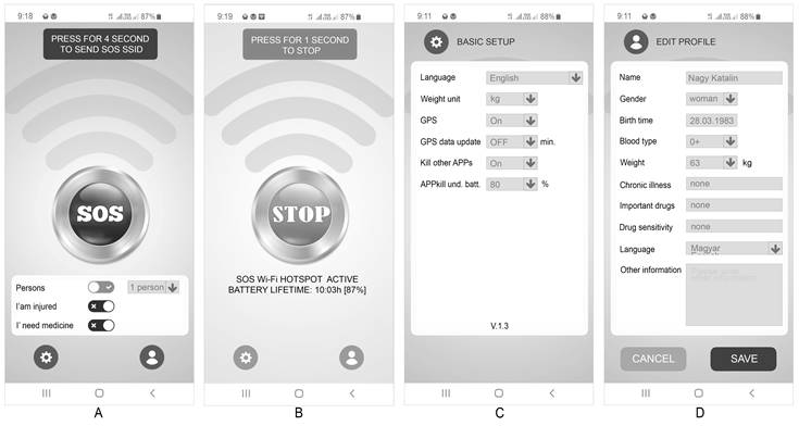
TERRESTRIAL TRANSMITTER STATION The ground transmitter station will be established by a software environment (SOS-SSID application) created for mobile devices. With this software, the person in trouble will be able to turn their device into a wireless network transmitter station, or – in other words – a hotspot. The mobile phone converted using the software can transmit information for assistance by radiofrequency for up to ten hours when charged. The windows of the program perform the following functions, which are shown in Figure 27. A) Main Screen – A large SOS button to initiate an emergency call. The function can only be activated by four seconds of continuous pressing, to eliminate accidental activation. Different kinds of instant information can be selected on the main screen using quick switches. Profile setting and basic setting options are also available as submenus. B) Emergency Call Active Status Screen – This page shows the emergency call application in active status. The following information is displayed here: The maximum expected operating time and battery charge, as well as the STOP button that interrupts the active service. In the active state, it is no longer possible to enter or modify basic data. This was necessary because the application had to generate a new SSID for each modification or new information. C) Basic Application Settings Screen – This interface allows the user to customize the application’s language, the unit of mass, the active status switch of the positioning system, the interval for regenerating the SSID due to changing coordinates, and settings for stopping other applications. D) Personal Profile Creation Screen – Provides basic information about the user. There are fill and select fields on the interface.
Figure 2. SOS-SSID screenshots – “A” Basic screen, “B” Active SOS hotspot, “C” App settings, “D” Profile settings, basic data.
indecs-20-230-g2.jpg
The code sequence generated by the application contains the SOS prefix, geographical coordinates and the name of the person8. The Wi-Fi SSID can be up to 32 characters long. The SOS-SSID application thus combines the SOS prefix and the characters to follow this pattern: SOS_47.504102,19.134257_NAGY_KAT9. At the same time, the application on the phone creates a static HTML page with the personal and important dates, which are as follows: • positioning coordinates: lat. 47.504102, lon. 19.134257 – the number of coordinate characters has been chosen to show the location within 5 meters after decoding, • name: na. nagy katalin – all characters are used when encoding the name, • date of birth: bd. 1983 – only the year numbers of the birth information is used for coding, • number of people: pe. 01 – with this option, the software allows the user to record the number of people in trouble. the default coding value is 1, • injury: in. 1 – this option allows a person in distress to notify the rescue team if they have an injury. this option is disabled by default, • medication requirements: me. 0 – this option allows a person in distress to indicate to the rescue team if they need medication. this option is disabled by default, • user gender: ge. w – man or woman can be selected within the application, • blood type: bl. 0+ – this option is used to enter the blood type, • person’s weight: wekg. 63 – the person’s weight is recorded and coded in kilograms by the application, • chronic illness: ci. 00 – with this option, the person in distress can signal to the rescue team if they have a chronic illness. this can be selected from a database. this option is disabled by default, • notable medications: id. 00 – this option allows the person in distress to indicate to the rescue team what notable medications they are taking regularly. these can be selected from a database. this option is disabled by default, • drug sensitivity: ds. 00 – with this option, a person in distress can signal to the rescue team if they have a known drug sensitivity. these can be selected from a database. this option is disabled by default, • spoken languages: la. hu-en – this option allows the person in trouble to indicate to the rescue team in which languages they can communicate. these can be selected from a database. the abbreviation of the hungarian language (hu) is coded by default, • other information: oi. 00 – the person can record other important information up to 40 characters long. this option is disabled by default. The generated static HTML page data sample follow this pattern: LAT: 47.504102_LON: 19.134257_NA:NAGY.KATALIN_BD:1983_PE:01_ IN:1_ME:0_GE:W_BL:0+_WEKG:63_CI:00_ID:00_DS:00_LA:HU-EN_OI:00 DRONE-MOUNTED RADIOFREQUENCY DETECTION COMPONENT The primary task of the drone-mounted scanning component is to locate the person in trouble through their mobile device. The mobile device acting as a radio frequency transmitting station and the SOS-SSID application running on it transmit the information which is then received by a drone-mounted radiofrequency detection component and transmitted to the terrestrial drone operator (search team). The drone-mounted reconnaissance component consists of a hardware and software environment. The hardware component includes a converted mobile phone for detecting Wi-Fi signals, an external antenna, and a radio frequency transmitter for transmitting the acquired data. The radio channels of the drone control and the drone component of the SOS-SSID system have been chosen so that they do not interfere with the search frequencies, which, in our case are 2,4 and 5 GHz. Testing and trial measurements of the system were performed at two sites. Figure 3 shows an image taken by a drone camera in a densely populated area and a field and a mobile device requesting assistance. In both cases, the mobile phone we were looking for was placed on the ground in an opened, non-covered area and we were running the SOS-SSID application on the device.
Figure 3. Measurement sites and the SOS mobile phone.
indecs-20-230-g3.jpg
GROUND SUPPORT SYSTEM The developed drone component primarily aids the effort of the ground support system by providing decision-makers with reconnaissance data in addition to visual information. Such reconnaissance information includes the number and location of the emergency call devices and other information that can be extracted from the SSIDs. Figure 4 shows an image of a locator application running on an operator team test phone10,11.
Figure 4. Locator APP for mobile phone.
indecs-20-230-g4.jpg

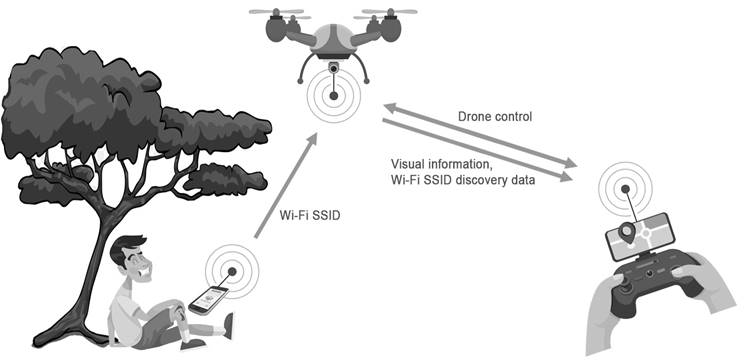
MEASUREMENTS WITH THE RADIO FREQUENCY DRONE COMPONENT

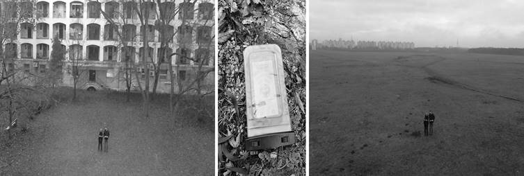
To obtain accurate results, we have done measurements on the efficiency of our development with different software and hardware pairings under different terrain conditions. Our tools used in the tests are: • ground mobile Wi-Fi hotspot – SOS-SSID transmitter (Vernee mobile), • drone and drone control (F550 drone), • Wi-Fi scanner application + drone-mounted data transmitter (Samsung A70), • evaluation applications (Wi-Fi heatmap scanner application, SOS-SSID decoder application on Samsung S10 and Huawei P20 mobile). We started our measurements with the SSID search. The radio system on the drone was set to scanner mode and the drone was given a pre-programmed flight path. After filtering the results obtained during the flight, we identified the exact location of the ground transmitter for SOS_XXXXXXXX. In the second step, we were able to localize the device using a Wi-Fi heat mapping application. This is a confirmatory test to verify that the device which provided the location data had sent it accurately. In the absence of accurate positioning data, the result of the second measurement leads to a target. FIRST SITE DENSELY POPULATED AREA Even before we started the measurements, we were aware that we would find several interfering Wi-Fi devices at this measurement site, which was confirmed by the scanning. At the time of the first measurement, 162 active Wi-Fi devices were listed, of which the SSID starting with SOS was easily identifiable. Figure 5 shows the result of a part of the measurement12,13.

Figure 5. SSIDs gathered in a densely populated area.
indecs-20-230-g5.jpg
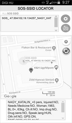
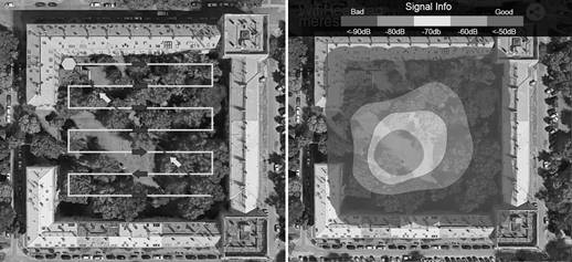
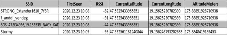
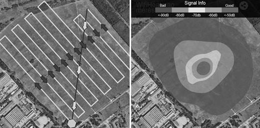
The coordinates recorded by the scanning application do not determine the exact location of the devices, but the drone’s location at detection. Therefore, a second, more accurate measurement based on Wi-Fi heat mapping is needed. It can determine the position of a specific SSID with an accuracy of a few meters14. The drone scanned around the coordinate of the SOS-SSID location identified in the first measurement. With this flight pattern and using the Wi-Fi Heat Mapping application, we got Figure 615.
Figure 6. To the left, the flight path of the drone. The right side shows the measured location of the mobile phone that broadcasts the selected SOS SSID.
indecs-20-230-g6.jpg
Second site – Field The method used for the first measurement was repeated at a second location, a field. From our experience, we knew that radio pollution would be lower at this location. Our assumption was confirmed, we were able to record a total of 4 SSIDs in the field, which also included our own SOS-SSIDs. Figure 7 shows our measurement result. Wi-Fi heat mapping was also performed at this location. Its result is shown in Figure 8.
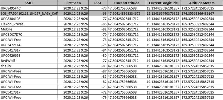
Figure 7. SSIDs gathered in a thinly populated area.
indecs-20-230-g7.jpg
Figure 8. To the left, the flight path of the drone. The right side shows the measured location of the mobile phone that broadcasts the selected SOS SSID.
indecs-20-230-g8.jpg

CONCLUSIONS

During the developments, we were able to create and successfully test an SOS-SSID radiofrequency system that may be suitable to be integrated into disaster management agencies’ systems. During our measurements, it was confirmed that the system we created works efficiently. All its components work in harmony with each other. With this system, the search time can be reduced and human life can be saved. The prepared article and the information contained in it demonstrated the operation of a prototype. Its integration into disaster management systems requires further development.

References

1 

Berek L., et al.: Security of persons and property. In Hungarian. Obuda University: Budapest,2016.

2 

Kovács T., Jackovics P.: Investigating A Rope Rescue Accident. Hadmérnök,13,172-181, 2018.

3 

Kovács T., Viplak A.M.: Drones In Security Technology. In Hungarian. Hadmérnök,12,7-13, 2017.

4 

Rajnai Z., Végh A.: Development Directions of Mobile Systems to Help Human Resources. Defence Review: the central journal of the hungarian defence forces,147, 23-37, 2019.

5 

Wührl T.: Drone communication: Efficient implementation of I – Q modulation with DSP. In Hungarian. Repüléstudományi közlemények,31,5-14, 2019.http://dx.doi.org/10.32560/rk.2019.2.1

6 

Pető R.: Some Safety and security issues of UAVS. Acta Technica Corviniensis – Bulletin of engineering,3,55-60, 2017.

7 

Szűcs E., Szakali M.: Formation and development of defense design models. In Hungarian. Hadmérnök,12,24-40, 2017.

8 

Wührl T., Bódi A., Szabó T.: Tracking drones in a public way. In Hungarian. Repüléstudományi közlemények,29,111-118, 2017.

9 

Farkas T., Hronyecz E.: Basic information needs in disaster situations (capabilities and requirements). A XXI. Fiatal Műszakiak Tudományos Ülésszaka, Műszaki tudományos közlemények,5, 153-156, 2016.


Mester Gy., Sostaric D.: Drone Localization using Ultrasonic TDOA and RSS Signal - Integration of the Inverse Method of a Particle Filter. FME Transactions,48,21-30, 2020.http://dx.doi.org/10.5937/fmet2001021S


Sostaric D., Mester Gy., Dorner S.: Mobile ECG and SPO2 Chest Pain Subjective Indicators of Patient with GPS Location in Smart Cities. Interdisciplinary Description of Complex Systems,17(3),629-639, 2019.http://dx.doi.org/10.7906/indecs.17.3.17

12 

Rajnai Z., Albininé Budavári E.: The role of additional information in obtaining information. Interdisciplinary Description of Complex Systems,17(3),438-443, 2019.http://dx.doi.org/10.7906/indecs.17.3.2

13 

Farkas T., Parada I.: Detection and Analysis in the Penetration Test - 1. Information Gathering Techniques. In Hungarian. Hadmérnök,15,159-182, 2020.

14 

Pokorádi L.K., Boucetta S.I., Johanyák Zs. Cs.: Survey on software defined VANETs. Gradus,4,272-283, 2017.

15 

Gyöngyösi K., Varga P.J., Illési Zs.: WLAN heat mapping in hybrid network. Informatics 2017, 14th International Scientific Conference on Informatics Proceedings,94-97, 2017.http://dx.doi.org/10.1109/INFORMATICS.2017.8327228


This display is generated from NISO JATS XML with jats-html.xsl. The XSLT engine is libxslt.