License (open-access, http://creativecommons.org/licenses/by-sa/4.0/):
CC-BY-SA
License (open-access):
Prava korištenja: CC-BY-SA
License (open-access):
Journal content is published under CC-BY-SA licence.
Publication date: 2021
Volume: 20
Issue: 35
News
Centuriation of the Andautonian Ager, Roman Cadastre
Marijan Kadi
The Roman city Andautonia was established on the location of today's village of Šćitarjevo in the 1st century.
The city was considered a municipality (a city with self-government). The territory belonging to Andautonia covered the Sava River valley, in the area of today's city of Zagreb with a
natural border: the Samobor Hills in the west, Medvednica in the north, Zelina river in the east and Vukomerić Hills in the south.
307190
2.4.2021.
![]()
Visits: 2.774 *
The Roman city Andautonia was established on the location of today's village of Šćitarjevo in the 1st century. The city was considered a municipality (a city with self-government). The territory belonging to Andautonia covered the Sava River valley, in the area of today's city of Zagreb with a natural border: the Samobor Hills in the west, Medvednica in the north, Zelina river in the east and Vukomerić Hills in the south.
The fertile Sava River valley has since time immemorial been suitable for settlers , and was first urbanized when the Romans arrived and built Andautonia. Centuriation, i.e. cadastral survey of the agricultural land made it possible for people to manage the newly established estates well (Nemeth, Kušan 2007). Smaller settlements and economies (villa rustica) were established at the time, some of which continued developing in the centuries following the fall of the Roman Empire (V. Gorica, Stenjevec).
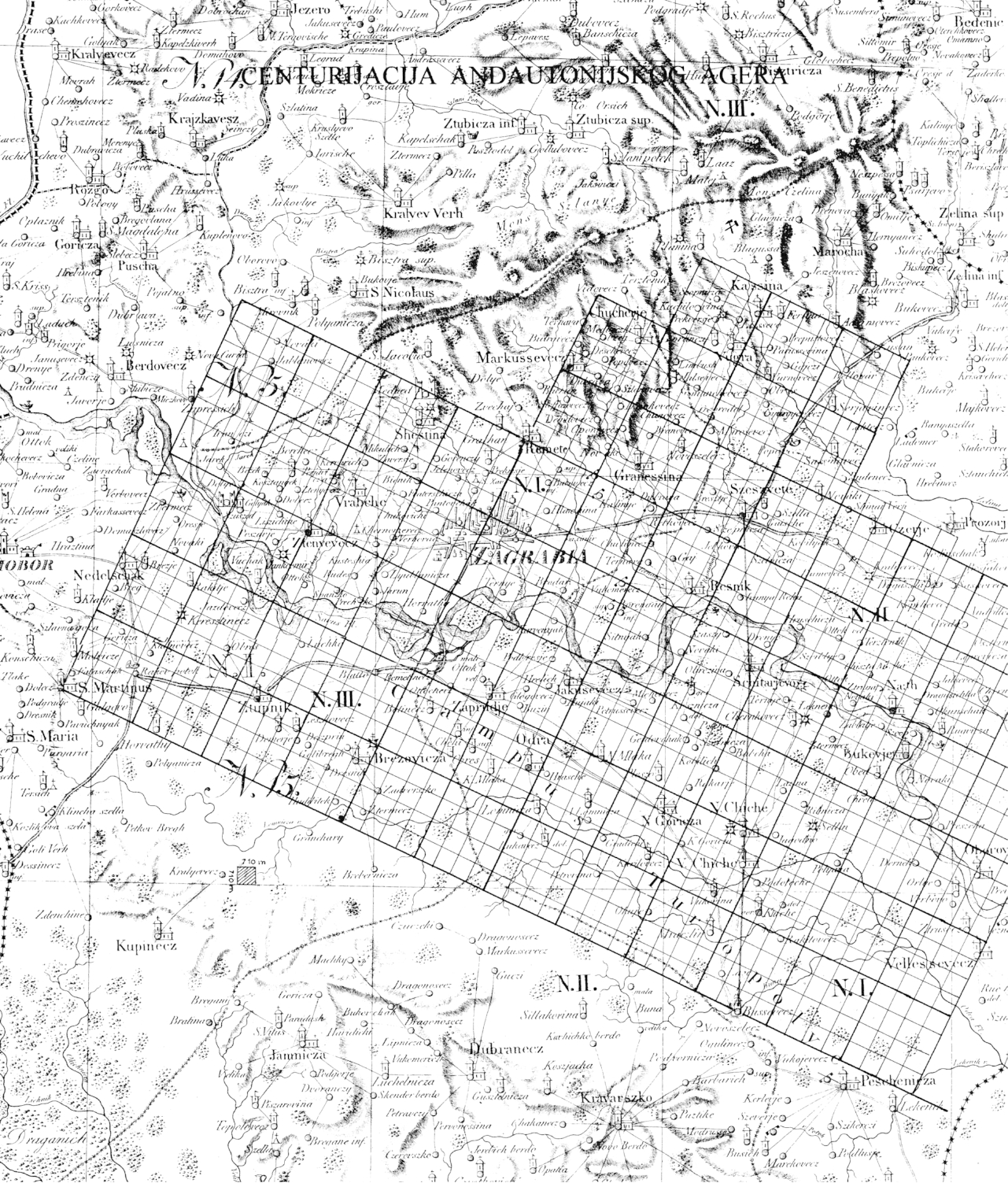
The centuriation did not encompass the entire Andautonian ager (field), only the designated part, i.e. where state-owned land was assigned to private owners. The remaining areas were used for public needs, forests and common pastures. The present research project aimed to discover as many traces of Roman centuriation of the Andautonian ager as possible and to represent a potential centuriation grid on a map. Boundaries of the Andautonian ager centuriation have not been fully determined in the present research project.
Centuriation is regular cadastral parcelling, which was named after a parcel – centuria. The entire ager was surveyed and the centuriation grid was represented in an orthogonal system. Two perpendicular axes pass through the centre of the system. The term centuria corresponds to the system of dividing soldiers into centuriae in legions and is related to dividing land to colonists, some of whom were Roman legion veterans. Paths separating individual centuriae or groups of centuriae are called limes.
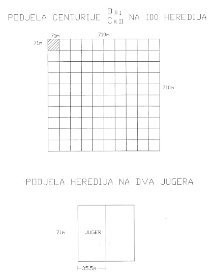
A centuria is divided into 100 heredii. A heredium is a basic unit, which can be further divided into 2 jugerums. A jugerum is an empirical unit based on the use of oxen for tilling in one day. Sides of one centuria are 710 m long and its area is 50.4 ha. A heredium has an area of 0.5 ha, while a jugerum has an area of 0.25 ha.Figures 1 and2 show the system of marking areas and dividing the centuriae.
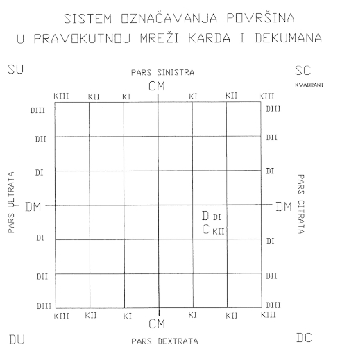
Figure 1 shows a rectangular grid with two axes passing through its centre. The axis stretching from east to west is called the decumanus maximus (DM), while the axis stretching from north to south is called the cardo maximus (CM). They divide a centuria into four quadrants: (SU), (SC), (DC) and (DU).
The deviation of direction (CM) of the Andautonian ager from the geographic north toward northeast amounts to 22.5° and depends on the spreading of the Sava River and the surrounding hills. The origin of the assumed cardo maximus (CM) is the southern exit from Andautonia and its trace can be seen in an aerial image. The decumanus maximus (DM) was not observed during the research project, but it can be assumed it is the decumanus which starts at the point of origin and matches the old Radnička Street in Zagreb.
Furthermore, the reconstructed trace of the main Roman road Siscia-Andautonia breaks at the point of origin of centuriation and through the settlement centre follows the direction in which the city stretches.
Surveying was carried out by surveyors (mensores), land surveyors (agrimensores) and gromatics using a device called the groma. Roman surveyors used gromas to peg out perpendicular straight lines while delmiting agricultural land. More information about gromas can be found in Kadi (2016).
All traces of Andautonian ager centuriation which have been found so far were drawn onto the map "City of Zagreb", scale 1:50 000, which was produced by the Institute for Cadastre and Geodetic Works, while centuriation lines were discovered and drawn based on obtained evidence. In order to carry out the research project and prove the accuracy of the established centuriation grid for the entire area of the ager, it was necessary to collect 54 sheets of the Croatian Base Map (Hrvatska osnovna karta – HOK) in the 1:5000 scale and 20 old cadastral plans in the 1:2888 scale transformed to the 1:5000 scale. The 1:50 000 scale map was used to read the coordinates of border points of centuriae which were transferred to the 1:5000 maps (HOK), on which I drew centuriation lines. Afterwards, it was easy to follow the details (paths, parcels and churches) which correspond to or are parallel with centuriation lines, and to mark them on the map.
I applied three different approaches in my past work on Roman parcelling. The first case was the Salonitana ager. It is the triangular area bounded by Stobreč-Klis-Solin. Zorzi Calergi produced a topographic cadastral map of this area in 1675. While restoring and correcting the map, I noticed the represented paths on the corrected map are centuriation grid lines. The existing centuriae are marked with regular lines on the restored map, while dotted lines represent the remaining raster of Roman parcelling (Kadi 1988).
The second case is related to centuriation of the Ugljan island (Kadi 2016). The drywalls which determined borders of centuriae exist today and are represented on the map of the north-western part of the island. These stone witnesses of Roman parcelling stretch for 20 km and have been preserved in this part of the island. Observing existing parcel orientation, we can see most parcels preserved the centuria orientation.
In contrast to the centuriation of the two previously mentioned agers, the traces of which can be found in stone, there are no such visible traces for the Andautonian ager, or they are hidden underground. Therefore, it was necessary to start collecting and researching old maps and cadastral plans which represent the field prior to recent urbanization. Aerial images were used to find traces of the Roman road, as well as parts of Roman centuriation. Archaeological excavations and the position of the discovered sites in space were a significant part of the work on discovering the centuriation. Details on maps, plans and aerial images which helped to discover centuriation traces included churches, road, field roads, parcels, narrow strips of felled forest and settlements.
The position of churches on plans and maps contributed to discovering the centuriation. Churches built in the early Middle Ages, and even later ones, were constructed next to the existing paths which were in most cases limes (borders of centuriae).
I modified Szeman’s map of the Zagreb Diocese from 1822 (Figure 3) by drawing a centuriation grid in which it can be noticed that the position and layout of some older churches corresponds to the centuriation. We can note the following churches: St. Martin in Dugo Selo, St. Martin under Okić, chapel of St. John the Baptist in Buševec, St. Mary in Stenjevec and Mother of God in Remete.
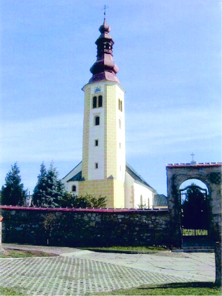
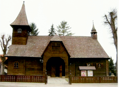
On the map of the greater Zagreb area, scale 1:50 000 (Figure 4), which served as the basis of Roman parcelling of the Andautonian field (ager), we can follow how churches fit into the centuriation grid. These churches include: St. Simon in Markuševac (Figure 5), Mother of God in Remete, chapel of St. Anna in Obrež, St. Martin in Dugo Selo, St. Florian and Sebastian in Kučine, Blessed Virgin Mary in Vukovina (Figure 6), Annunciation of the Blessed Virgin Mary in Velika Gorica, St. Barbara in Velika Mlaka (Figure 7), St. George in Odra, St. Benedict in Stupnik, St. John of Nepomuk in Lučko, Assumption of the Blessed Virgin Mary in Stenjevec, St. Martin under Okić (Figure 8), Holy Trinity in Lekenik, Assumption of the Blessed Virgin Mary in Pešćenica, Assumption of the Blessed Virgin Mary in Nart and chapel of St. John the Baptist in Buševec (Figure 9).

In ancient times, there used to be sanctuaries (altars) by paths at which people could worship Roman gods. These altars were established at crossroads (intersections of centuriation lines which divide estates of individual landowners).
Boundary points in intersections of preserved paths of Roman centuriation were sometimes marked with crosses or chapels in the Middle Ages. For some of them, there is written evidence on when they were built, as well as when churches were constructed on their foundations.
While doing fieldwork, I discovered the wooden cross (poklonac) in Kurilovec and the chapel of the Heart of Jesus in Gradići are located exactly at the intersection of centuriation lines.
I used the following plans and maps while researching and producing the centuriation map of the Andautonian ager:
- Szeman’s map of the Zagreb Diocese from 1822. Scale 1:192 000.
- Plans produced in the first cadastral survey in 1864. Scale 1:2880.
- Croatian Base Map (Hrvatska osnovna karta – HOK), scale 1:5000, produced between 1959 and 1968.
- Topographic map from 1978, scale 1:25 000.
- Contemporary maps 1:50 000 and 1:100 000.
I indicated evidence of centuriation traces on maps and plans on certain sheets, and here I would like to emphasize the most significant observed details.
Savska Street and Radnička Street are perpendicular to each other. Savska Street is parallel to the centuriation grid, while Radnička Street matches the grid. There is a road connection between V. Gorica, Kurilovec, Donja Lomnica and Pleso, matching the Roman parcelling grid. In addition, the Church of Annunciation of the Blessed Virgin Mary in V. Gorica lies on the centuriation line. The road passing through Stupnik completely matches the centuriation line. In addition, the Church of St. Benedict lies on the same line of the centuriation grid as the road. Historical documents mention a Roman road in the old village of Stupnik and that these good old Roman roads were also used for a long time in the Middle Ages. It can be noticed that the road through Stupnik deviates from the centuriation line and at Demerje, it leads via a shortcut to Obrež, where it continues to follow one of the Roman parcelling lines.
The road through Sesvetski Kraljevec, as well as the path from Sesvetski Kraljevec to the Village of Cerje towards the Church of St. John divides the centuriae in two, and the road from Cerje to Budinec follows the centuriation line. The orientation of Sesvetski Kraljevec with its surroundings indicates the existence of a possible economic settlement in Roman times.
In the area of Mala Mlaka and the water pumping station, many parcels within individual centuriae preserved the orientation of Roman parcelling, and some of the current paths even indicate the division of individual centuriae in four parts. The paths through the Obrež settlement and parcels north of the settlement respect the centuriation lines for the most part. On the western side of the old city of Lukavec, there is a regular division of one centuria into four parts which is determined by the existing/current paths.
Roman centuriation of the Andautonian field (ager) in the area of Velika Gorica was the dominant orientation in the urban development of the settlement. Subsequent development of the settlements in the centuries following the fall of the Roman Empire followed the orientation established by the Roman survey. In a more detailed division of a centuria from 710 m to 355 m, we find many paths and parcels corresponding to the Roman raster. The main street in V. Gorica – Zagrebačka Street – divides the Roman centuria into two equal parts. The Roman road from Andautonia (Šćitarjevo) via Bapće village passes by V. Gorica and connects with the main traffic connection Siscia-Emona in the Village Ogulinec.
Between Mala Mlaka and Odra in the north and Lomnica river in the south, there is arable land which has preserved the orientation of the Roman parcelling. In addition, paths through settlements and field roads leading to parcels have the same direction as the centuriae.
In the greater city area – Stenjevec, Jankomir and Savska Opatovina, we can see roads and paths correspond to and are parallel with the centuriation raster. The Church of St. Mark in Stenjevec also fits into this raster. A memorial plaque indicating a Roman settlement in the 1st and 2nd centuries was placed in the church courtyard. A number of parcels and field roads in the area are parallel with the centuriation grid.
We follow narrow strips of felled forest which stretch between Sesvetska Sela in the north and the Zagreb-Koprivnica railway in the south. Narrow strips of felled forest have preserved the orientation of the Roman parcelling.
The border between the Stupnik and Blato cadastral districts is easy to notice. It stretches for 2 km and is approximately parallel with the centuriation line.
The area between V. Gorica and V. Mlaka has been irreversibly losing its agricultural land due to the unstoppable pressure of urban development and construction. This area of the golden valley of the Sava River shows a perfect match between parcels and field roads with the Roman parcelling. The road which connects V. Gorica and V. Mlaka divides centuriae in two.
Parcels of Veliko Polje in the western part of Velika Gorica clearly indicate the Roman orientation and consequently the orientation of the urban development of the settlement itself. Narrow strips of felled forest in the area of Obrež forests, as well as field roads leading from Obrež follow the centuriation grid, and they even match in some places.
The aerial image of the Obrež forest shows the Roman cadastre parcels correspond to narrow strips of felled forest to some extent, and to some extent they are parallel to them. The centuriation line mostly corresponds to paths in the aerial image which encompasses a part of V. Gorica and a part of V. Polje, and a part of the existing parcelling has preserved the direction of certain centuriae. We can observe a trace of the Roman road on the image encompassing the area between Šćitarjevo and Črnkovec. A trace of one tumulus can also be seen by the Roman road.
1. Roman settlement in Stenjevec
Archaeological excavations in Stenjevec started in the 19th century, when an antique necropolis with 128 graves was found. Based on all existing excavations, it can be concluded that a settlement from the Roman period existed in Stenjevec in the 1st and 2ndcentury.
2. Church of St. Martin in Prozorje near Dugo Selo
The Institute for Archaeology, led by Juraj Belaj, MSc carried out an excavation by the church of St. Martin in October and November of 2002. Most findings are from the late Middle Ages. Some bricks and ceramics from the Roman times were also found.
3. Necropolis from the Roman period and the church of Annunciation to the Blessed Virgin Mary in Velika Gorica
Several graves from the antique period were found when a necropolis was discovered in Visoki Brijeg in Velika Gorica during excavations between 1908 and 1927. Antique material was also found near the parish church of Annunciation to the Blessed Virgin Mary.
4. Assumed cardo maximus
The southern necropolis located at the beginning of Šćitarjevo, by Kutelo, was partially explored during the 1980s. Traces of a Roman road (assumed cardo maximus) were discovered by the necropolis. The same road was discovered while building a new detour for V. Gorica at the Črnkovec village in 2011. Both findings were surveyed.
5. Probe research at the centuriation line
After a longer period of studying old plans, maps and field work represented on the map of the Zagreb area (scale 1:50 000), I drew the centuriation grid (Figure 4) of the Andautionian field (ager). In order to make the centuriation plan credible, it was necessary to corroborate it with archaeological excavations. Therefore, the first centuriation line east of the cardo maximus was selected. Coordinates of six locations on the line were read from the map and probes were used on those location.
In order to obtain permission for excavation from the Ministry of Culture, it was necessary to determine the numbers of parcels corresponding to those points. At the same time, we transferred the parcels and coordinates of the points planned for probing to an orthophoto plan 1:5000 which we used to facilitate orientation in the field. In November 2012, we studied using probes, organized by the Archaeological Museum in Zagreb and led by custodian Dorica Nemeth. Probes were distributed within a distance of 1000 m. We determined the position of probes in the field using a GPS device (60CSX-Garmin) with the reliability of ±3m.
Research results in all probes were positive. Longitudinal profiles for each probe were drawn in the field. In probe photographs, one can see the base of a Roman road after the alluvial layer was removed. The height of the alluvial layer was between 0.5 and 1 m.
Let us emphasize that the current field road (c.p. 154/50) between probes 5 and 6 corresponds to the boundary line of the centuriation. We can say that the boundary line established in the Roman Empire has been continuously maintained up to the present day and that surveyors were able to restore the boundary line after large floods and alluvial depositions.
6. Roman stela
In 2012, 750 m west of Lekneno village, an accidental discovery was made of a Roman stela by a field road, the orientation of which corresponds to the division of the Roman centuriation. Further research of the stela’s environment may reveal a Roman graveyard.
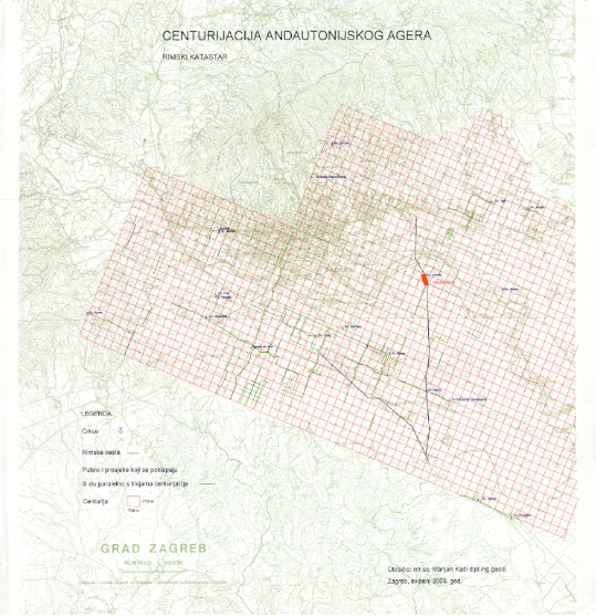
This research project resulted in the map "Centuriation of the Andautonian Ager. Its scale is 1:100 000 and its size is 68×52 cm. The map contributes to the archaeological research of the Sava River valley in the greater Zagreb area. Since traces of the Roman cadastre (as a monument of the antique heritage) have been partially discovered and preserved, they represent an inexhaustible source of information relevant to reconstructing the antique history of the Croatian territories. We particularly need to emphasize the region of the Šćitarjevo Posavina, an area in almost untouched nature with the preserved Roman city of Andautonia in its centre (1st – 4th century).
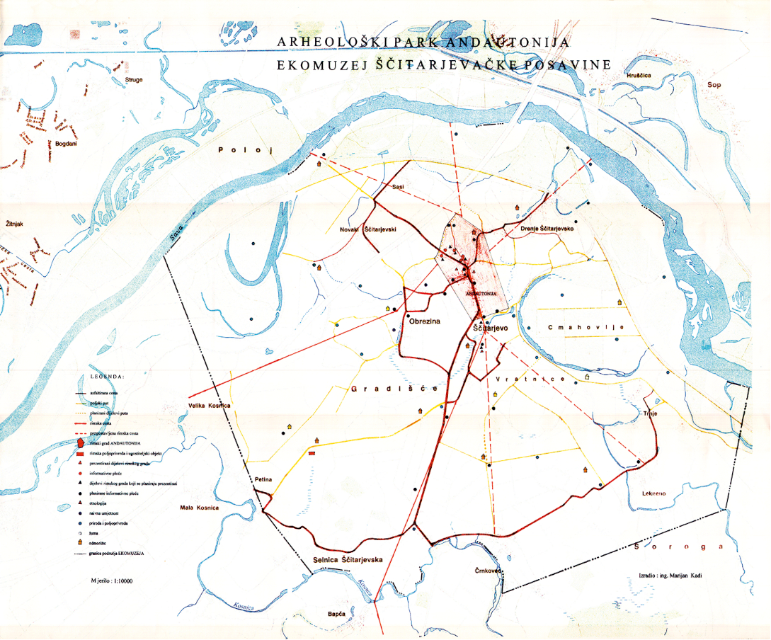
In addition to the existing archaeological park in Šćitarjevo, custodians of the Archaeological Museum in Zagreb and leaders of the project "Ecomuseum of the Šćitarjevo Posavina" Dorica Nemeth Ehrlich and Dora Kušan Špalj wanted to represent this untouched landscape as a museum in a natural environment. In 2008, on the occasion of the exhibition 2000 Years of Andautonia in the Archaeological Museum, I produced the map Ecomuseum of the Šćitarjevo Posavina which shows, among other content, a part of the centuriation of the Roman city of Andautonia.
Establishing a network of paths which enclose a part of centuriae in the surroundings of Andautonia, as well as stabilization of a certain number of Roman boundary stones, enable presentation of agricultural activities in Roman survey parcels.
Rimski grad Andautonija osnovan je u 1. st. na prostoru današnjeg sela Šćitarjeva. Grad je imao status municipija (grad sa svojom samoupravom). Teritorij koji je pripadao Andautoniji prostirao se dolinom rijeke Save na području današnjeg grada Zagreba s prirodnom granicom: na zapadu Samoborsko gorje, na sjeveru Medvednica, na istoku rijeka Zelina i na jugu Vukomeričke gorice.
Ta je plodna savska dolina od prapovijesti bila povoljna za naseljavanje, a prva je urbanizacija toga prostora provedena dolaskom Rimljana i izgradnjom grada Andautonije. Uređenjem poljoprivrednog zemljišta katastarskom izmjerom – centurijacijom stvoreni su uvjeti dobroga gospodarenja na novonastalim posjedima (Nemeth, Kušan 2007). Tada nastaju manja naselja i privredna gospodarstva (vile rustike) od kojih će se neka i nakon propasti Rimskog Carstva u narednim stoljećima razvijati i opstati (V. Gorica, Stenjevec).
Centurijacijom nije obuhvaćen čitav andautonijski ager, već samo onaj njegov dio na kome su bile izvršene adsignacije – dodjeljivanje državne zemlje u privatne posjede. Površine koje su ostale služile su za javne potrebe, šume i zajedničke pašnjake. Ovim se istraživačkim radom nastojalo otkriti što više tragova rimske centurijacije andautonijskog agera i na karti prikazati moguća mreža centurija. Rubne granične linije centurijacije andautonijskog agera ovim istraživanjem nisu točno određene.
Centurijacija je pravilna katastarska parcelacija, a ime je dobila po čestici – centuriji. Cijeli je ager izmjeren i mreža centurija prikazana je u ortogonalnom sustavu. Središtem sustava prolaze dvije osi strogo okomite jedna na drugu. Ime centurija u skladu je sa sustavom podjele vojnika na centurije u legijama i u vezi je s postupkom podjele zemlje kolonistima koje su činili i veterani rimskih legija. Staze koje odvajaju pojedine centurije ili grupe centurija nazivaju se limesi.
Centurija se dijeli na 100 heredija. Heredij je temeljna jedinica i dijeli se još na dva jednaka dijela, na 2 jugera. Juger je empirijska mjera nastala upotrebom volovske vuče pri oranju u jednom danu. Stranica jedne centurije iznosi 710 m, a njezina je površina 50,4 ha. Jedan heredij ima površinu 0,5 ha, a jedan juger 0,25 ha. Kako je tekao sustav označavanja površina i podjele centurije, prikazano je naslikama 1 i2.
Naslici 1 prikazana je pravokutna mreža čijim središtem prolaze dvije osi. Os koja ide od istoka prema zapadu naziva se decumanus maximus (DM), a os koja ide od sjevera prema jugu naziva se cardo maximus (CM). One dijele centuriju na četiri kvadranta: (SU), (SC), (DC) i (DU).
Otklon pravca (CM) andautonijskog agera od geografskog sjevera prema sjeveroistoku iznosi 22,5°, a uvjetovan je prostiranjem rijeke Save i okolnoga gorja. Pretpostavljeni glavni kardo (CM) ima ishodišnu točku na južnom izlazu iz rimskog grada Audantonije i njegov trag možemo lijepo pratiti na aviosnimci. Glavni dekumanus (DM) nije uočen prigodom istraživanja, ali se može pretpostaviti da je to onaj dekumanus koji ide iz ishodišne točke i u produžetku se idealno poklapa sa starom Radničkom cestom u Zagrebu.
Nadalje, rekonstruirani se trag glavne rimske ceste Siscija-Andautonija lomi u ishodišnoj točki centurijacije i dalje kroz središte naselja prati smjer protezanja grada u prostoru.
Izmjeru zemljišta izvodili su mjernici (mensori), zemljomjernici (agrimensori) i gromatici s pomoću mjerne sprave koja se nazivala groma. Tom su gromom rimski mjernici iskolčavali okomite pravce prilikom limitacije poljoprivrednog zemljišta. Više o gromi pisao je Kadi (2016).
Svi su dosad prikupljeni nalazi tragova centurijacije andautonijskog agera ucrtani na kartu „Grad Zagreb" u mjerilu 1:50 000, koju je izradio Zavod za katastar i geodetske poslove, a na temelju prikupljenih nalaza otkrivene su i iscrtane linije centurijacije. Za cijelo područje agera za potrebe istraživanja i dokazivanja ispravnosti postavljene mreže centurija bilo je potrebno prikupiti 54 lista Hrvatske osnovne karte (HOK) u mjerilu 1:5000 te 20 starih katastarskih planova u mjerilu 1:2888 prevedenih u mjerilo 1:5000. S karte 1:50 000 očitane su koordinate rubnih točaka centurija i prenesene na karte (HOK) 1:5000 na kojima sam iscrtao linije centurijacije. Nakon toga bilo je lako pratiti detalje (putovi, parcele i crkve) koji se poklapaju ili idu paralelno s linijama centurija te ih naznačiti na karti.
U svojim dosadašnjim radovima na istraživanju rimskih parcelacija naveo bih tri različita pristupa toj temi. U prvom se slučaju radi o salonitanskom ageru. To je područje što ga čini trokut Stobreč-Klis-Solin. Za to je područje izradio Zorzi Calergi 1675. godine topografsko-katastarsku kartu. Prigodom obnavljanja i ispravljanja karte uočio sam da su prikazani putovi na ispravljenoj karti zapravo linije mreže centurija. Na obnovljenoj karti pune linije označuju još postojeće centurije, a točkastim je linijama prikazan ostatak rastera rimske parcelacije (Kadi 1988).
U drugom se slučaju radovi odnose na centurijaciju otoka Ugljana (Kadi 2016). Na karti sjeverozapadnog kraja otoka, kao i na cijelom otoku, postoje i danas suhozidi koji su određivali granice centurija. Ti su kameni svjedoci rimske parcelacije sačuvani do danas na tom dijelu otoka u dužini od 20 km. Promatrajući današnju orijentaciju parcela, vidimo da je većina parcela zadržala orijentaciju centurija.
Za razliku od prethodno spomenuta dva agera, čije tragove centurijacije možemo naći u kamenu, za andautonijski ager možemo reći da vidljivih tragova na prvi pogled nema ili da su pod zemljom. Tu je trebalo početi s prikupljanjem i istraživanjem starih karata i katastarskih planova koji prikazuju stanje terena prije novije urbanizacije. U istraživanju su korištene i aviosnimke na kojima se mogu iščitavati tragovi rimske ceste, kao i dijelovi rimske centurijacije. Vrlo važan dio radova na otkrivanju centurijacije su arheološka istraživanja i položaj otkrivenih lokaliteta u prostoru. Detalji na kartama, planovima i aviosnimcima koji su pomogli u otkrivanju tragova centurijacije su: crkve, ceste, poljski putovi, parcele, šumske prosjeke i naselja.
Položaj crkvi na planovima i kartama pridonio je otkrivanju centurijacije. Crkve koje su nastale u ranom srednjem vijeku, pa i one kasnije, sagrađene su uz postojeće putove koji su u većini slučajeva predstavljali limese (granice centurija).
Na Szemanovu sam kartu Zagrebačke biskupije iz 1822. godine (slika 3) ucrtao mrežu centurijacije na kojoj se može uočiti da se položaj i raspored nekih starijih crkava uklapa u centurijaciju. Tu možemo navesti crkvu sv. Martina u Dugom Selu, crkvu sv. Martina pod Okićem, kapelu sv. Ivana Krstitelja u Buševcu, kapelu sv. Marije u Stenjevcu i Majke Božje u Remetama.
Na karti šireg područja grada Zagreba u mjerilu 1:50 000 (slika 4), koja je poslužila kao podloga izrade rimske parcelacije andautonijskog agera, možemo pratiti kako se crkve uklapaju u mrežu centurija. To su crkva sv. Šimuna u Markuševcu (sl. 5), svetište Majke Božje u Remetama, kapela sv. Ane u Obrežu, sv. Martina u Dugom Selu, sv. Florijana i Sebastijana u Kučima, Blažene Djevice Marije u Vukovini (sl. 6) crkva navještenja Blažene Djevice Marije u Velikoj Gorici, sv. Barbare u Velikoj Mlaki (sl. 7), sv. Jurja u Odri, sv. Benedikta u Stupniku, sv. Ivana Nepomuka u Lučkom, uznesenja Blažene Djevice Marije u Stenjevcu, sv. Martina pod Okićem (sl. 8), Svetog Trojstva u Lekeniku, uznesenja Blažene Djevice Marije u Pešćenici, uznesenja Blažene Djevice Marije u Nartu i kapela sv. I. Krstitelja u Buševcu (sl. 9)
U doba staroga Rima postojala su pokraj putova svetišta (žrtvenici) na kojima se moglo štovati rimske bogove. Takvi su žrtvenici postavljeni na raskrižjima putova (presjecima linija centurijacije koje razgraničuju zemljišta pojedinih zemljoposjednika).
U srednjem su vijeku međne točke na sjecištima još sačuvanih putova rimske centurijacije ponegdje obilježene križevima ili kapelama. Za neke od tih kapela imamo pisanih tragova kada su podignute, a također i kada su na njihovim temeljima sagrađene crkve.
Prilikom obilaska terena otkrio sam da se križno drvo (poklonac) u Kurilovcu i kapelica Srca Isusova u mjestu Gradići upravo nalaze na presjeku linija centurijacije.
Kod istraživanja i izrade karte centurijacije andautonijskog agera upotrijebljeni su planovi i karte:
Szemanova karta Zagrebačke biskupije iz 1822 .godine, mjerilo karte 1 : 192 000
planovi nastali prvom katastarskom izmjerom iz 1864. godine, mjerilo planova 1 : 2880
Hrvatska osnovna karta (HOK) u mjerilu 1:5000 nastala između 1959. i 1968. godine
topografska karta u mjerilu 1:25 000 iz 1978. godine
suvremene karte 1:50 000 i 1:100 000.
Nalaze tragova centurijacije na kartama i planovima izdvojio sam i prikazao na pojedinim listovima, a ovdje navodim najznačajnije uočene detalje.
Savska ulica i stara Radnička ulica međusobno su okomite. Savska ide paralelno, a Radnička se poklapa s mrežom centurija. Postoji cestovna povezanost V. Gorice, Kurilovca, Donje Lomnice i Plesa koja se uklapa u mrežu rimske parcelacije. Također i crkva navještenja Blažene Djevice Marije u V. Gorici leži na liniji centurijacije. Cesta koja prolazi kroz Stupnik potpuno se poklapa s linijom centurijacije. I crkva sv. Benedikta leži na istoj liniji mreže centurija kao i cesta. U povijesnim se dokumentima spominje rimska cesta u starom selu Stupniku i napominje da su te stare dobre rimske ceste ostale u upotrebi još dugo u srednjem vijeku. Može se opaziti da se cesta kroz Stupnik odvaja od linije centurijacije i kod Demerja ide prečacom prema Obrežu da bi dalje pratila jednu od linija rimske parcelacije.
Cesta kroz Sesvetski Kraljevec, kao i put od Sesvetskog Kraljevca do sela Cerje prema crkvi sv. Ivana, dijeli centurije po pola, a od Cerja prema selu Budincu put prati liniju centurijacije. Orijentacija Sesvetskog Kraljevca s okolinom upućuju na moguće postojanje gospodarskog naselja u rimsko doba.
Na području Male Mlake i vodocrpilišta velik je broj parcela unutar pojedinih centurija zadržao smjer rimske parcelacije, a neki današnji putovi čak ukazuju na podjelu pojedinih centurija na četiri jednaka dijela. Putovi kroz naselje Obrež i parcele sjeverno od naselja u velikom broju poštuju linije centurijacije. Sa zapadne strane starog grada Lukavca pravilna je podjela jedne centurije na četiri dijela koju određuju današnji putovi.
Rimska centurijacija andautonijskog agera na području V. Gorice bila je dominantna orijentacija pri urbanom razvoju samog naselja. I kasniji razvoj naselja u stoljećima poslije Rima zadržao je orijentaciju u prostoru koju je postavila rimska izmjera. Ako idemo još u detaljniju podjelu centurije sa 710 m na 355 m, naći ćemo dosta putova i parcela koje se poklapaju s rimskim rasterom. Glavna ulica u V. Gorici (Zagrebačka ulica) dijeli rimsku centuriju na dva jednaka dijela. Rimska cesta od Andautonije (Šćitarjevo) preko sela Bapće prolazi pored naselja V. Gorica i spaja se s magistralnom cestom Siscia-Emona u selu Ogulinec.
Između Male Mlake i Odre na sjeveru te rijeke Lomnice na jugu prostiru se oranice koje su i danas zadržale orijentaciju rimske parcelacije. Također, putovi kroz naselja te poljski pristupni putovi do parcela imaju isti smjer centurija.
Središnji dio sela Petine zatvaraju putovi koji se djelomično poklapaju s linijama centurijacije, a djelomično idu paralelno. Unutar te središnje centurije današnje su parcele zadržale njezinu orijentaciju.
Na širem području grada – Stenjevec, Jankomir i Savska Opatovina vidimo poklapanje i paralelnost cesta i putova s rasterom centurija. Crkva sv. Marije u Stenjevcu također se uklapa u taj raster. U dvorištu crkve postavljena je spomen-ploča na kojoj piše da je na tom mjestu u 1. i 2. st. bilo rimsko naselje. Na tom je području i danas veliki broj parcela i poljskih putova paralelan smrežom centurija.
Pratimo šumske prosjeke koje se protežu između Sesvetskih Sela na sjeveru i pruge Zagreb – Koprivnica na jugu. Šumske prosjeke zadržale su i danas orijentaciju rimske parcelacije.
Vrlo je uočljiva granica između katastarske općine Stupnik i katastarske općine Blato. Ona se proteže u duljini od 2 kilometra i približno je paralelna s linijom centurijacije.
Područje između V. Gorice i V. Mlake svakim danom nepovratno gubi svoje poljoprivredno zemljište pod nezaustavljivim pritiskom urbanog razvoja i nagle izgradnje. Taj dio površine zlatne Savske doline pokazuje savršeno podudaranje parcela i poljskih putova s rimskom parcelacijom. Cesta koja spaja V. Goricu i V. Mlaku dijeli centurije popola.
Parcele Velikog Polja na zapadnom kraju Velike Gorice jasno upućuju na rimsku orijentaciju, a time i na orijentaciju urbanog razvoja samog naselja.
Šumske prosjeke na području obreških šuma, kao i poljski putovi koji izlaze iz sela Obrež, prate mrežu centurija, a na nekim se mjestimapoklapaju.
Na aerofotogrametrijskoj se snimci Obreške šume vidi da se rimski raster parcelacije djelomično poklapa sa šumskim prosjekama, a djelomično ide paralelno s njima. Na aerofotogrametrijskoj snimci koja obuhvaća dio V. Gorice i dio V. Polja linije centurijacije dobrim se dijelom poklapaju s putovima na snimku, a dio postojeće parcelacije zadržao je smjer pojedinih centurija. Na snimci koja obuhvaća područje između Šćitarjeva i Črnkovca možemo uočiti trag rimske ceste. Pored rimske ceste također je vidljiv trag jednog tumula.
1. Rimsko naselje u Stenjevcu
Arheološka istraživanja u Stenjevcu započela su u 19. st. kad je pronađena antička nekropola s ukopom 128 grobova. Na temelju rezultata svih dosadašnjih istraživanja može se zaključiti da je naselje iz rimskog doba u Stenjevcu postojalo u 1. i 2. stoljeću.
2. Crkva sv. Martina u Prozorju kraj Dugog Sela
U listopadu i studenom 2002. proveo je Institut za arheologiju pod vodstvom mr. sc. Jurja Belaja istraživanja uz crkvu sv. Martina. Većina nalaza potječe iz kasnosrednjovjekovnog doba. Osim toga nađeni su neki nalazi iz rimskog vremena (opeke i ulomci keramike).
3. Rimskodobna nekropola i crkva navještenja Blažene Djevice Marije u Velikoj Gorici
Na položaju Visoki brijeg u V. Gorici 1908–1927, kada je provedeno iskopavanje, otkrivena je nekropola te pronađeno više grobova iz antičkoga razdoblja. Antički materijal pronađen je i u blizini župne crkve navještenja Blažene Djevice Marije.
4. Pretpostavljeni glavni kardo (cardo maksimus)
Južna nekropola smještena na početku naselja Šćitarjevo, na predjelu Kutela, istražena je djelomično 1980-ih godina. Uz nekropolu su otkriveni tragovi rimske ceste (pretpostavljenoga glavnog karda). Ta je ista cesta otkrivena 2011. prigodom izgradnje nove obilaznice za V. Goricu na području sela Črnkovca. Oba su nalaza geodetski snimljena.
5. Istraživanje sondi na liniji centurijacije
Nakon dužeg proučavanja starih planova, karata i obilaska terena na karti zagrebačkog područja u mjerilu 1:50 000 ucrtao sam mrežu centurijacije (sl. 4) andautonijskog agera. Kako bi taj plan centurijacije bio vjerodostojan, trebalo je arheološkim iskapanjem potvrditi istinitost plana. U tu je svrhu izabrana prva linija centurijacije istočno od glavnog karda. S karte su očitane koordinate na šest mjesta na liniji gdje je sondirano.
Za dobivanje dozvole od Ministarstva kulture za iskapanje sondi bilo je potrebno vidjeti na koje brojeve parcela padaju te točke. Usput smo te parcele i koordinate točaka predviđenih za sondiranje prenijeli na ortofoto plan 1:5000, što nam je poslužilo za lakšu orijentaciju na terenu. U studenom 2012. pristupili smo istraživanju sondi u organizaciji Arheološkog muzeja u Zagrebu pod vodstvom kustosice Dorice Nemeth. Sonde su raspoređene unutar udaljenosti od 1000 m. Položaj sondi na terenu odredili smo GPS uređajem (60CSX-Garmin) s pouzdanošću ±3m.
Rezultati istraživanja u svim sondama bili su pozitivni. Na terenu su iscrtani uzdužni profili za svaku sondu. Na fotografijama sondi može se vidjeti podloga rimskoga puta nakon što je skinut naplavni sloj. Visina naplavnog sloja varirala je od 0,5 do 1 m.
Istaknimo da se današnji poljski put (k.č. 154/50) između sonde 5 i sonde 6 poklapa s graničnom linijom centurijacije. Možemo reći da je jednom uspostavljena granična linija u Rimskom Carstvu bila održavana u kontinuitetu do danas i da su mjernici nakon velikih poplava i nanosa naplavina ponovno obnavljali međnu liniju.
6. Rimska stela
Rimska stela pored koje prolazi poljski put čija se oruiju rimsko groblje.
Rezultat ovoga rada je karta „Centurijacija andautonijskog agera“. Izrađena je u mjerilu 1:100 000 i veličine 68×52 cm. Karta je doprinos arheološkom istraživanju doline rijeke Save na širem zagrebačkom području. Budući da su tragovi rimskog katastra (kao spomen antičke baštine) djelomično otkriveni i sačuvani, oni predstavljaju nepresušno vrelo informacija u rekonstrukciji antičke povijesti hrvatskih prostora. Posebno treba istaknuti prostor šćitarjevačke Posavine, kraj koji je do danas gotovo netaknute prirode i koji u svom središtu čuva rimski grad Andautoniju (1–4. st.).
Osim već postojećeg arheološkog parka u Šćitarjevu, voditeljice projekta "Ekomuzej šćitarjevačke Posavine", djelatnice Arheološkog muzeja u Zagrebu, kustosice Dorica Nemeth Ehrlich i Dora Kušan Špalj željele su taj još uvijek netaknuti pejzaž prikazati kao muzej u prirodnom okolišu. Povodom izložbe „2000 godina Andautonije“ u Arheološkom sam muzeju 2008. godine izradio kartu „Ekomuzej šćitarjevačke Posavine“ na kojoj je, uz ostale sadržaje, prikazan dio centurijacije oko rimskog grada Andautonije.
Uspostava mreže putova koji zatvaraju dio centurija u okolišu Andautonije, kao i stabilizacija određenoga broja rimskih međnih kamena, pruža mogućnost prezentacije poljoprivredne djelatnosti na parcelama rimske izmjere.