Skoči na glavni sadržaj

Izvorni znanstveni članak

https://doi.org/10.32909/kg.21.si.8

Otok Korčula na ranonovovjekovnim kartama

Lena Mirošević orcid id orcid.org/0000-0002-8016-9783 ; Sveučilište u Zadru, Odjel za geografiju
Josip Faričić ; Sveučilište u Zadru, Odjel za geografiju


Puni tekst: hrvatski pdf 7.227 Kb

str. 99-125

preuzimanja: 37

citiraj

Puni tekst: engleski pdf 7.227 Kb

str. 98-124

preuzimanja: 25

citiraj

Preuzmi JATS datoteku


Sažetak

U radu se na temelju odabranih kartografskih prikaza Korčule iz ranoga novog vijeka razmatraju geografske spoznaje o tom otoku u vrijeme izrade karata. Posebna pozornost usmjerena je na do sada nepoznatu kartu otoka Korčule iz druge polovine 16. ili prve polovine 17. st. koja se čuva u Archivio do Stato di Venezia s obzirom na to da je na njoj dan vrlo detaljan prikaz otoka Korčule, posebno njegovoga zapadnog dijela. Cilj je ovoga rada na primjeru otoka Korčule uputiti na važnost kartografskih prikaza kao važnog izvora prostornih podatka te utvrditi je li došlo do postupnoga unaprjeđenja kvalitete prikazanoga geografskog sadržaja u skladu s pretpostavljenim razvojem geografskih spoznaja i kartografskih tehnika od početka 16. st. do kraja 18. st. Na temelju odabranih kartografskih prikaza otoka Korčule potvrđeno je značenje otoka Korčule u pomorsko-geografskim okvirima obilježenim različitim političkim interesima, ponajprije Venecije. Dijakronijski niz ranonovovjekovnim geografskih i pomorskih karata upućuje na postupni razvoj geografskih spoznaja o otoku Korčuli kao i na unaprjeđenje kvalitete grafičke vizualizacije relevantnih prostornih podataka o tom hrvatskom otoku.

Ključne riječi

stare karte; geografska imena; otok Korčula; Dalmacija; Hrvatska

Hrčak ID:

290625

URI

https://hrcak.srce.hr/290625

Datum izdavanja:

3.1.2023.

Podaci na drugim jezicima: engleski

Posjeta: 528 *


Notes

[1] After the Treaty of Zadar in 1358, the rule of the Zorzi family over Korčula and the conflicts with their dukes over property on the island ended. The Korčula Grand Council made a decision in 1409 to divide the former duke's land between nobles and commoners, which was done in the Agreement on the Division of Land in 1411. (Foretić 1940).

[2] Manicules are one of the most common symbols that readers wrote in the margins of manuscripts and/or publishers inserted into printed books in the period from the 12th to the 18th century. This small hand with the extended index finger was primarily used to indicate a particularly important passage of text (Sherman 2010).

[3] The geographical name of the Korčula port Pidocchio is associated with the piloting of ships in and out of the port. The 1272 Dubrovnik code uses the terms pedochya, pedocia, peđotla (Gjivoje 1969).

[4] Given that one Venetian fathom (passo veneto) was 1.738562 m long (Herkov 1977, 147), this would mean that the depths in the Pelješac Channel were between 35 m and 42 m. In the narrowest parts of that channel between the town of Korčula and Pelješac and between the islets of Veli Kneža and Pelješac, the depths are indeed approximately in that range, while in other parts they are greater (as can be determined by verifying contemporary nautical charts and topographic maps of the Republic of Croatia).

[1] O točnosti pomorskih karata Jadrana od 13. do 16 st. doktorski rad objavio jeT. Marelić (2020).

[2] Nakon Zadarskog mira 1358. prestala je vlast porodice Zorzi nad Korčulom i sukobi s njihovim kneževima oko posjeda na otoku. Korčulansko veliko vijeće donijelo je odluku 1409. godine da se nekadašnja kneževa zemlja podjeli između plemića i pučana što je i učinjeno Ugovorom o podjeli zemlje 1411. godine (Foretić 1940).

[3] Manicule je jedan od najčešćih simbola koje su čitatelji upisivali na margine rukopisa i/ili umetali izdavači u tiskane knjige u razdoblju od 12. do 18. stoljeća. Takva mala ruka s ispruženim kažiprstom prvenstveno se koristila za označavanje posebno važnog odlomka teksta (Sherman 2010).

[4] Geografsko ime korčulanske luke Pidocchio dovodi se u vezu s peljarenjem brodova u luku i iz nje tj. u dubrovačkom zakoniku iz 1272. peljarenje se naziva pedochya, pedocia, peđotla (Gjivoje 1969).

[5] S obzirom na to da je jedan mletački hvat (passo veneto) bio dug 17,738562 m (Herkov 1977, 147), to bi značilo da su dubine u Pelješkom kanalu između 35 m i 42 m. Na najužim dijelovima tog kanala između grada Korčule i Pelješca te između otočića Veli Kneža i Pelješca dubine su doista približno u tom rasponu, dok su u drugim dijelovima veće (kako je to moguće utvrditi uvidom u suvremene pomorske i topografske karte Republike Hrvatske).

References / Literatura


Board C (2011) Cartographic Communication. In: Dodge M, Kitchin R, Perkins C (eds) The Map Reader: Theories of Mapping Practice and Cartographic Representation, Wiley and Sons, Ltd,37-48


Borzić I (2009) Uvala Gradina na otoku Korčuli u svjetlu podmorskih arheoloških nalaza. In: Bekić L (ed), Jurišićev zbornik - Zbornik radova posvećenih uspomeni na Marija Jurišića. Hrvatski restauratorski zavod, Zagreb, 82-97


Campbell T (1987) Portolan Charts from the Late Thirteenth Century to 1500. In: Harley J B, Woodward D (eds), The History of Cartography, Volume 1: Cartography in Prehistoric, Ancient, and Medieval Europe and the Mediterranean. University of Chicago Press,ChicagoZagreb, 371-463


Cosgrove D (1992) Mapping new worlds: Culture and cartography in sixteenth century Venice. Imago Mundi, 44, 1, 65-89


Dokoza S (2003) Iz gospodarske i društvene povijesti Blata do 18. stoljeća. In: Šeparović T (ed.), Zbornik radova znanstvenog skupa Blato do kraja 18. stoljeća. Blato, 117-138


Dokoza S (2009) Dinamika otočnog prostora, Društvena i gospodarska povijest Korčule u razvijenom srednjem vijeku. Književni krug Split,Split


Dokoza S , author. (2022) Najstarije spominjanje Vele Luke u pisanim izvorima (građa za povijest Vele Luke u srednjemu vijeku), (u tisku).


Gautier Dalché P (2007) The Reception of Ptolemy's Geography (End of the Fourteenth to Beginning of the Sixteenth Century). In: Woodward D (ed) The History of Cartography, Volume 3: Cartography in the European Renaissance, Part 1. University of Chicago Press,Chicago, 285-364.


Faričić J (2011a) Kartografske aktivnosti u Dalmaciji tijekom francuske uprave 1806. - 1813. In Šanjek F (ed.), Hrvati i Ilirske pokrajine (1809. - 1813.). Hrvatska akademija znanosti i umjetnosti,Zagreb, 353-377


Faričić J (2011b) Geografska imena na starim kartografskim prikazima otoka Paga. In: Skračić V (ed.), Toponimija otoka Paga. Sveučilište u Zadru,Zadar, 523-605


Faričić J (2013) Silba na starim geografskim i pomorskim kartama. In: Mužinić J, Purger J J (eds.), Otok Silba - Prirodno i kulturno blago. Sveučilište u Zadru,Zadar, 143-164


Faričić J (2017) Kartographische Tätigkeiten in Dalmatien während der zweiten österreichischen Herrschaft. In: Stojić A, Pavić Pintarić A (eds.), Kroatiens Küste im Lichte der Habsburgermonarchie, Transkulturelle Forschungen an den Österreich-Bibliotheken im Ausland, Band 16. New Academic Press,Wien, 141-159


Faričić J (2022) Descriptio oeconomiae - prikazi ekonomskih aktivnosti na ranonovovjekovnim kartama sjeverne Dalmacije. Rad HAZU, Razred za društvene znanosti, 550 = 56, 233-260.


Faričić J, Marelić T, Levačić P, Šinko-Depierris Đ (2020) Hrvatski otoci na kartama u Velikom izolaru i peljaru Andréa Theveta. Hrvatski geografski glasnik, 82, 2, 39-79.


Foretić V (1940) Otok Korčula u srednjem vijeku do g. 1420.. Jugoslavenska akademija znanosti i umjetnosti,Zagreb


Gjivoje M (1969) Otok Korčula, Zagreb


Herkov Z (1977) Prinosi za upoznavanje naših starih mjera za dužinu i površinu - nastavak. . Zbornik Odsjeka za povijesne znanosti Zavoda za povijesne i društvene znanosti Hrvatske akademije znanosti i umjetnosti, 8, 143-215.


Juran K, Barzman K, Faričić J (2019) Kartografija u službi Mletačke države: karta sjeverne i srednje Dalmacije nepoznatog autora s početka 16. stoljeća. Geoadria, 24, 2, 93-139.


Kozličić M (1995) Kartografski spomenici hrvatskog Jadrana. AGM,Zagreb


Kozličić M, Faričić J (2010) Toponimi otoka Murtera i susjednih otočića na starim geografskim i pomorskim kartama. In: Skračić V (ed.), Toponimija otoka Murtera. Sveučilište u Zadru,Zadar, 123-135


Kozličić M, Faričić J (2016) Značenje Vira u pomorsko-geografskom sustavu Jadrana u prošlosti. In: Magaš D (ed.), Otok Vir. Sveučilište u Zadru i Općina Vir,Zadar, 255-274


Lago L, Rossit C (1984) Pietro Coppo Le 'Tabvlae' (1524-1526), Una preziosa raccolta cartorafica custodita a Pirano. Universita popolare di Trieste,Lint, Trieste


Marelić T , author. (2020) Točnost prikaza Jadranskog mora na portulanskim kartama, doktorski rad, Sveučilište u Zadru, Zadar.


Maričić Z (1997) Vela Luka od 1490. do 1834: slike iz velolučke prošlosti, Vela Luka


Marković M (1993) Descriptio Croatiae. Naprijed,Zagreb


Mayhew T (2008) Dalmatia between Ottoman and Venetian Rule - Contado di Zara 1645-1718, Roma


Pavić M (2000) Plovidbena ruta sjevernim Jadranom u izolaru Giuseppea Rosaccija. Radovi Zavoda za povijesne znanosti HAZU u Zadru, 42, 173-194.


Pavić M (2013) Otočnici (izolari) - svjedočanstva o europskom i mediteranskom identitetu Hrvatske. Miscellanea Hadriatica et Mediterranea, 1, 201-215.


Robinson A, Petchenik B (1975) The Map as a Communication System. The Cartographic Journal, 12, 1, 7-15.


Sherman W H (2010) Used Books: Marking Readers in Renaissance England. University of Pennsylvania Press,Philadelphia


Šipić I (2010) Novi prilozi kultu sv. Lucije na istočnom Jadranu. Senjski zbornik, 37, 19-32.


Vrandečić J, Bertoša M (2007) Hrvatska povijest u ranome novom vijeku, Vol. 3: Dalmacija, Dubrovnik i Istra u ranome novom vijeku. Leykam International,Zagreb


Wintle M (1999) Renaissance maps and the construction of the idea of Europe. Journal of Historical Geography, 25, 2, 137-165.


This display is generated from NISO JATS XML with jats-html.xsl. The XSLT engine is libxslt.


1. Introduction

Cartographic renderings are an important source of information about space and an expressive medium of communication that contains data about space and in prostoru (Robinson and Petchenik 1975,Board 2011). Before the application of geodetic procedures, primarily surveys, which, in the case of the Croatian Adriatic area, were systematically carried out from the beginning of the 19th century (Faričić 2011a,2017), the contents of a map depended a lot on the author's personal competences, on the (un)applied mathematical-cartographic elements (map projection, scale), on the choice of content that depended on the level of geographical knowledge and on the cartographic generalization ability and the application of appropriate cartographic means of expression. As a result, there were often many errors on the maps in terms of the accuracy of the representation of geographic reality (location of geographic objects, linear and areal distortions, etc.). In addition, the content of the maps was influenced by the purpose of the map as well as the intention of the author or the person who ordered the map. Regardless of which spatial units were depicted and with what level of knowledge about space and intentions, maps were a communication mechanism between different stakeholders, the most important among them being the cartographers and map users. In addition to the transmission of information about the space, they also contained (un)conscious messages of political interests or power to the users (Wintle 1999).

For the rendering of the north-eastern coast of the Adriatic during the early modern age (from the beginning of the 16th to the end of the 18th century), the most important maps are of Venetian provenance. They were created in the context of political and economic influences in the mentioned area, while other European authors mainly compiled materials from Venetian cartographic originals. Venice, as a political and commercial centre whose economy depended on maritime trade, had a need for accurate cartographic depictions of its trading sphere, but also of its possessions on land (terraferma) and across the sea (stato da mar) (Cosgrove 1992,Juran et al. 2019). Given that the navigation route along the north-eastern coast of the Adriatic, as one of the links between Europe and the Mediterranean, was of great traffic importance, Venice was interested in knowing the geographical features of that area, which logically resulted in its cartographic rendering.

In this context, it is necessary to consider the cartographic depictions of one of the largest Adriatic islands − Korčula in southern Dalmatia. The representations of the island of Korčula and the surrounding area bear witness to the importance of the coastal navigation route, along which there were recognizable navigation landmarks, as well as precious spatial resources (ports with drinking water supplies, agricultural products, etc.). Island bays provided a safe harbourage in case of bad weather. In case of not knowing the area, the island of Korčula and the surrounding islets and reefs as well as shoals were dangerous for (Kozličić and Faričić 2010). Although most early modern maps with a more detailed view of the coast and islands belonged to the corpus of nautical charts and maps published in isolarios, they should not be viewed exclusively as a source of navigational data. In addition to data relevant to navigation, their content also included other spatial data. In this respect, nautical charts were complementary to geographical maps. Cartographic renderings of the island of Korčula with their geographical, demographic and economic data form the basis for reading the historical geographical spatial organization of that Dalmatian island. At the same time, the map as a medium of communication influenced knowledge and the dissemination and acquisition of new spatial data about the displayed space (Faričić 2011b,2013).

2. Methodology and Spatial Framework of the Research

The research results are based on the analysis of 19 selected originals of old maps kept in the State Archives in Zadar, State Archives in Dubrovnik, Croatian State Archives, Archivio di Stato di Venezia in Venice, National and University Library in Zagreb, University Library in Split, Österreichische Nationalbibliothek in Vienna and the British Library in London and reproductions of the originals that are available in digital version on the websites of the Stanford University Libraries (The Renaissance Exploration Map Collection), the Greek foundation The Aikaterini Laskaridis (Laskaridis Digital Collection) and the Liechtenstein Sylvia Ioannou Foundation (Books and manuscripts). One printed copy published in the book byL. Lago and C. Rossit (1984) was also analysed. The research does not include all maps with depictions of Korčula, but those that we consider to be representative samples on the basis of which it is possible to draw relevant conclusions about the gradual improvement of the quality of the geographical content shown on cartographic depictions of that Croatian island during the early modern era, with a brief review of the maps that preceded them. Those maps were chosen based on which it is possible to diachronically follow the continuous development of the cartographic renderings of the island of Korčula, with regard to the established patterns and innovations in the selection and method of displaying geographical content, or stagnation, as the case may be, with regard to the acquisition of geographical content from older templates, which points to uncritical reproduction, i.e. poorer knowledge of the basic geographical features of that Croatian island in the era that preceded systematic geodetic surveys.

The map of the island of Korčula, which is kept in the Archivio di Stato di Venezia, has been dealt with in more detail. It is a hitherto unknown map, which we judge by the fact that no one has even mentioned it in Croatian scientific literature (or we are not aware of it). The authors came across this map quite by accident while searching nautical charts and geographical maps of the Adriatic in this and other archives and museums in Venice. In the State Archives in Venice, it is catalogued as a map by an unknown author from the second half of the 16th century. Its more precise dating and determination of its author are made impossible by damage to the edges, especially in the place where the text is located, making it therefore illegible. This text was written in the place where, on old maps, information about the title, author and year of creation of the map was usually given, inside the cartouche or without it (Figure 10).

The aim of this paper, using the example of the island of Korčula (and the neighbouring islets), is to point out the importance of early modern maps as a source of spatial data in historical-geographical analyses, and to give an account of the gradual improvement in the quality of the geographical content on these maps, which was connected with the improvement of geographical knowledge and the gradual increase in the quality of collection, processing and graphic visualization of spatial data about that Croatian island. In the analysis of the geographical content, emphasis was placed on toponyms, while other geographical elements were also investigated: relief, settlements, plant cover and various economic contents. Through the (absence of) toponyms on cartographic renderings, an attempt was made to determine the importance of the named geographic object by the one naming it, that is, the cartographer as an intermediary in the communication between (the residents) of the displayed area and the map user who, through this medium, tries to get an appropriate image of that area. The frequency of toponyms within the selected cartographic depictions is based on the assumption that identification using toponyms points to the importance of geographical objects, while respecting the different intentions and interests or the level of knowledge of the cartographer, as well as the methodology, which in many cases relied on the reproduction of older geographical and cartographic material.

A methodological approach to the research was applied, which was used until now by J. Faričić in his works on toponyms on geographical maps and nautical charts of certain Croatian islands (Faričić 2008, 2010,2013), relying on methodological patterns in the historical-cartographic analyses ofMarković (1993) andKozličić (1995). At the same time, early modern maps with depictions of Korčula were comparatively analysed, and conclusions were drawn about the researched cartographic sources of spatial data by induction through the diachronic sequence and correlation with relevant data published in the historiographical literature.

3. Representations of the Island of Korčula on Selected Overview Geographical Maps and Nautical Charts of Europe and the Mediterranean

3.1. Cartographic renderings of the island of Korčula on nautical charts and isolarii

If we exclude the Fifth Map of Europe by the ancient cartographer Claudius Ptolemy from the 2nd century, which was prepared for printing in several different versions from 1477 (Gautier Dalché 2007), so the appearance of the island of Korčula on that ancient map (Figure 1) is not known but can only be assumed, continuously more detailed cartographic depictions of the Adriatic began with nautical charts that started being made no later than the end of the 13th century (Campbell 1987). On these maps, the focus was on the geographical content of the coast of the mainland and the islands, relevant for the planning and implementation of navigational tasks, so only those geographical objects that fit into that content matrix were named. They were complementary in content to portolans (navigation manuals), so the name portolan chart is also used for the earliest such charts. These maps began to be made during the period of competition between several Adriatic powers, primarily Venice and the Hungarian-Croatian Kingdom, for supremacy over the north-eastern part of the Adriatic. Venice, after multiple interruptions since the end of the 10th century, from 1409 (on Korčula from 1420) established its rule over most of the north-eastern coast of the Adriatic and kept it in that area until 1797 (Vrandečić and Bertoša 2007). With the aim of controlling and administering this area, Venetian authorities began documenting and mapping spatial resources, so in addition to nautical charts, maps were also created which, according to today's map typologies in terms of their content, could be classified as topographical maps.

On nautical charts of the Adriatic, the island of Korčula is regularly shown and most often named. This is logical given the size and importance of this South Dalmatian island. However, the depictions of that island remained "frozen" for centuries on overview nautical charts of the Adriatic and those derived from them. The island is named C(o)rzola on Pietro Vesconte's map of the Adriatic (1318) (Figure 2), and Curzola on Pietro Coppo's map of the Adriatic (1525) (Figure 3), which is a name that belongs to the Venetian corpus of Adriatic toponymy. Along with Venetian and other South European authors, Vicko Dimitrije Volčić from Dubrovnik (Vincentius Demetrius Volcius Raguseus) also produced nautical cartographic depictions of the Adriatic coast. On his 1593 nautical chart of the Adriatic (Figure 4), the island of Korčula was recorded as Corzula in red, which he used to write the names of the most important geographical objects on the sea and on land (for instance the names of Dubrovnik, Kotor, Ston, the island of Hvar, the island of Vis, Mljet and Lastovo), in contrast to the less important geographical objects whose names he wrote in black. Volčić, originally from a town relatively close to Korčula, in his depiction of the coastline of that island made a step forward compared to older and foreign authors of nautical charts, so the vast Vela Luka Bay can be clearly recognized in his drawing. In addition, he mapped many islets and reefs near Korčula, making it clear that these are potentially dangerous objects for navigation.

A genre related to nautical charts and portolans were isolarii. These are collections of maps of the coastal area with associated texts (primarily descriptions of islands and harbours) with depictions of islands being predominant (Kozličić 1995,Faričić et al. 2020). The first among the isolarios depicting the Croatian islands was the Isolario nel qual si ragiona di tutte l'Isole del mondo by Benedetto Bordone, which was printed in Venice in 1528 (Kozličić 1995). In the 1534 version of Bordone's isolario, several Croatian islands are shown, including Korčula. The islands and coast are shown generalized. Only one settlement is shown on the island - the town of Korčula (curzola), while the Vela Luka Bay is shown, but not named, among the larger bays (Figure 5).

On Camocio's isolaro Isole famose porti, fortezze, e terre maritime sottoposte alla Ser.ma Sig.ria di Venetia, ad altri Principi Christiani, et al Sig.or Turco (1574), the island of Korčula is shown with the fortified town of Korčula (CVRZOLA) delimited by two bays with shipyards (squeri) and with a brief description of the siege and defence of the town of Korčula against the Turkish fleet in 1571 (Figure 6). The same map shows the islands in the Pelješac Channel: Bobarda (a name that probably refers to the nearby Korčula settlement of Lumbarda), Lamadona (the islet of Badija with a Franciscan monastery), Fornase (from Italian fornace, oven, which could refer to the limestone on the island of Majsan) and Forcha (most likely the islet of Lučnjak). The islets on the south side of the island of Korčula La lima (Mali and Veli Pržnjak, Trstenik, Gredica and Lukovac) and Carbon (Zvirinovik, which is located in front of the Karbuni harbour) are also shown. No toponyms are entered on the western side of the island. In his 1582 work Isulario et Portolano, the Greek sailor and cartographer Antonio Millo named the island of Korčula CHORCOLA, and the fortified town of Korčula as churzola (Figure 7). Millo's map of Korčula, as well as Camocio's map of Korčula, shows all the islets but only Lamadona, Forcha and Carbon are named. The French cartographer André Thevet showed the island of Korčula on a map in the 1586 navigation manual Le Grande Insulaire et Pilotage (Faričić et al. 2020). Thevet named the island by the nesonym Isle de Cursola, and the town of Korčula by the regional name Cursola (Figure 8). He also showed all the islets that are shown on Camocio's and Millo's map, while on the northern side of the island he particularly emphasized all the bays that are good for anchoring (Bonne sonde). The cartographer Giuseppe Rosaccio in his 1598 work Viaggio da Venetia a Costantinopoli depicted the island of Korčula (CRVZOLA) without the nearby islets in the Pelješac Channel (between the island of Korčula and the Pelješac peninsula). He named that channel with the hydronym Canal de Curzola, which today refers to the Korčula Channel between the island of Hvar and the island of Korčula (Figure 9).

The predominant feature of the depiction of the island of Korčula in the isolarii by G. F. Camocio, A. Millo, A. Thevet and G. Rosaccio is reflected in the deformed rendering of the coastline and the shape of the island. The depiction of the eastern coast of the island of Korčula, i.e. the area of the city (peninsula) of Korčula, was regularly exaggerated spatially in relation to the island's other spatial units. This way, they probably wanted to highlight the importance of the administrative and maritime position of the city of Korčula. The depiction of the real length of the island of Korčula and its west-east extension, with the town of Korčula on the east and the Vela Luka Bay on the west coast, was completely absent from all cartographic depictions. These distortions are primarily the result of poor knowledge of the geographical features of the displayed area and the absence of a unique linear scale (Faričić et al. 2020). An exception is Millo's cartographic rendering, which at the western end of the island of Korčula drew a deep bay with a castle and the toponym of St. John (s. Zuane). Such a depiction of the western part of the island somewhat reflects the actual situation, because in the 16th century the Vela Luka Bay housed four castles of the Korčula nobility and the small churches of St. Vincenzo and St. John in Gradina (Maričić 1997).

When considering the island and the town of Korčula, it is necessary to point out another specific feature. During the Middle Ages and the early modern era, the city of Korčula was of great importance. The favourable geo-traffic position of the city and the Pelješac Channel resulted in cartographic creations with emphasized depictions of the eastern part of the island of Korčula. Unlike the eastern part of the island, which was largely characterized by the urban and maritime functions of the city of Korčula, the western part of the island was an agrarian area with distinctly rural features. On that part of the island, agriculture was the main economic activity that developed on relatively large agricultural areas that belonged to Blato (Campi Blatta). In the central part of the island there were fields belonging to Smokvica (Campus Smoquize) and Čara (Campus Magnus Carre), while in the eastern part of the island there were only a smaller number of fields in Lumbarda (Campus Lombarde) and Žrnovo (Campus Zernove). There were none in the vicinity of the town of Korčula (Dokoza 2009). Such geomorphological features influenced the distribution and development of settlements. The convenience of the geographical location of Blato was based on its location next to the island's most important agricultural areas, but also on its distance from the sea and the fact that it was surrounded by hills, and thus was protected from attacks by pirates. On the oldest depictions of the island of Korčula, Blato was not mapped, probably primarily because they were focused on depicting the coastal area. At the same time, on the maps of Korčula published in the isolarios, the island's largest bay, the Vela Luka Bay, is not named on the west coast of the island, but rather the bays in front of the islets of La lima and Carbona on the south coast of the island. This is a consequence of intra-island traffic connections, i.e. the fact that the Vela Luka Bay − although a safe anchorage − was not in use. The island's only export port was Korčula. The transport of agricultural products from the western part of the island to the town of Korčula went through the ports of Prigradica and Prižba. Namely, the town of Korčula depended on the import of grain from Sicily and southern Italy, but this dependence was partially mitigated by the production of grain, especially barley, in the fields of Blato (Dokoza 2003).

3.2. Cartographic depiction of the island of Korčula by an unknown author from the Archivio di Stato di Venezia

While the geographical contents of the western part of the island of Korčula are mostly omitted on nautical charts, in this respect the map of the island of Korčula by an unknown cartographer from the Archivio do Stato di Venezia is much richer. In that archive, the map is dated to the second half of the 16th century, but no information on the map led us to confirm or reject such dating. In addition, not a single known document is associated with the map (or we did not find it by our omission), so the circumstances of its creation are not clear either. Unfortunately, the map is very damaged in the part where the text cartouche is located. The preserved part of the text does not have a single word that would refer to the map's author, circumstances and time of creation. We are inclined, therefore, to set the date more widely and assume that the map was created either in the second half of the 16th or in the first half of the 17th century. Namely, there are no genre analogies to that manuscript map of Korčula in the 16th century, while more detailed depictions of individual Croatian islands or parts of islands under Venetian administration date from the first half of the 17th century, such as, for example, Garsogani's 1610 map of Sutomišćica on the island of Ugljan, the oldest manuscript map from the Grimani Map collection of the State Archives in Zadar (Faričić 2022).

In contrast to the maps in the isolarios that were printed and had a greater impact, and certainly a wider user audience, the manuscript map of the island of Korčula was kept in one of the offices of the Venetian state administration and was not known to the wider geographical and cartographic community at the time. Because of this, its communication role is unfortunately framed within the Venetian administration. During the early modern period, the same was the case with other manuscript maps of smaller spatial units. Because they were intended as information on spatial resources or for determining land property relations in which a small number of officials and landowners were interested, they were not publicly available, and therefore, they could not serve as a source of spatial data when creating printed maps of larger spatial entities.

On the field of the map, the western part of the island of Korčula and its agricultural area are especially highlighted (Figure 10). Particularly interesting is the attention directed towards the Vela Luka Bay (Valle Grande) and the numerous toponyms within the bay (Vranaz, Tudoroviza, Privala, Cursar, Valle Bobovischia, Valle Gabriiza and Piscena Paricolar) which are still used as bay names today. Within the bay, the peninsula of St. John (S. Giovanni) with a church and the islets of Ošjak (scoglio Osciak) and Proizd (Proisd scoglio ) are also named. There was no settlement at the bottom of the Vela Luka Bay at that time, but only four castles of Korčula nobles (Izmaeli, Gabrijelić, Nikoničić and Kanavelić) and the church of St. Vincenzo and St. John in the Gradina Bay Gradina (Maričić 1997). All the mentioned objects are drawn on the map, except for the church of St. Vincenzo in the immediate vicinity of the castle.

In addition to the coastal area, toponymy is also rich in the agrarian area of Bradat (Bradar Conrado) with a prominent pond, while other agrarian areas are marked with a square sign. The distribution of squares in the vicinity of Blato, Smokvica and Čara corresponds to the most agriculturally significant areas on the island. Although the western part of the island was the focus of the unknown author, he does not highlight, as one would expect, the agriculturally most significant Blato fields. Namely, in the west of the island of Korčula, the agrarian backbone of development was the Blato field - Donje blato, and Potirna, but agricultural production was dispersed on all the fields or gentle slopes of the western part of the island. In addition to the agrarian advantage, the Bradat field was also well situated geographically. The field was located in the northern part of the Vela Luka Bay and had direct access to the bay or port of Gradina Sv. Ivana (St. John's Gradina), which was a completely sheltered anchorage. The Gradina Bay has been important since prehistoric times as a point of contact on the navigation route that connects the eastern and western shores of the Adriatic via the so-called Gargano - Tremiti - Palagruža - Sušac - Korčula - Hvar - Neretva island bridge. This connection is also confirmed by the ancient villa rustica in the eastern part of the Bradat field, i.e. the shore of Gradina, through which it communicated, as evidenced by the Roman wharf in the north-western part of the bay (Borzić 2009). Gradina Sv. Ivana (St. John's Gradina) was also of military importance in terms of monitoring the entrance to the Vela Luka Bay, but also over the Vis Channel.

On the basis of the historical toponyms from the few archival materials, it is possible, in comparison with the depiction on the map from Venice, to reconstruct the agrarian landscape. Gradina and Bradat stand out among the mentioned localities, which are mentioned in the documents on the division of the duke's land in 1411.[1] The Bradat field is also mentioned several times in other archival documents, as well as its smaller parts Bradat stup and Zabradat. The frequent naming of Bradat, as well as of smaller spatial units in archival sources points to the agricultural importance of that field. This is also confirmed by the ownership of several Korčula nobles over land parcels in that field (Dokoza 2022).

On the map, in addition to the city of Korčula and its usual panoramic depiction, all the island settlements (Blatta, Smogvirza, Kzzara, Pupnara, Zernova, Racischia, Lombarda and Curzola) are named, which are shown with a stylized drawing. Particularly interesting is the depiction of Blato, which clearly reflects the perception of the settlement as the demographic and agrarian centre of the island in the early modern era.

An interesting cartographic element on the map are manicules[2] that direct the user to the five island bays. These are Grdača Bay (Grherda) on the southern side of the island, and the bays Blaca (Blazza), Vaja or Samograd (Porto Barbier), Kneža (Knexa) and most likely Žrnovska banja (Sirechia Luka) on the northern side of the island of Korčula. It is difficult to determine why these ports are additionally highlighted with a map symbol of a small hand. It can be assumed that the intention of the unknown author was to highlight the key ports for intra-island maritime communication, i.e. the ports that connected the city of Korčula with the rest of the island.

The cartographic depiction of the island of Korčula stands out among the previously known and available cartographic depictions of the island. Namely, all other depictions of that island, mostly by Venetian but also other European authors, were identical in content. As a rule, they kept the same coastal representation with emphasis on the city of Korčula and the Pelješac Channel, affirming the administrative significance of the city, as well as the importance of the island in the maritime geographical system of the Adriatic and the Mediterranean.

As already pointed out, the Venetian administration over the greater part of the north-eastern coast of the Adriatic demanded greater involvement of the Venetian authorities in the mapping of Adriatic spatial resources. Considering the prevailing general depictions of Korčula on the maps of the Adriatic, it is most likely that the map by the unknown author was created as a reflection of the aspirations of the Venetian authorities for more detailed mapping of the island area, which until then was known only in basic outlines.

3.3. Cartographic depictions of the island of Korčula during the 17th and 18th centuries

The Venetian interest in cartographic depiction of the north-eastern coast of the Adriatic was further strengthened by political circumstances in the 17th and early 18th centuries. Most of today's Croatia was organized as a border area of the imperial powers of the Habsburg Monarchy, the Ottoman Empire and the Venetian Republic. In that period, there were three wars between Venice and the Ottoman Empire - the Candian War (1645 - 1669), the Morean War (1684 - 1699) and the Second Morean War (1714 - 1718). During those wars, Venice lost its possessions after which those wars were named (Candia - Crete and Morea - Peloponnese), but it significantly expanded its possessions in the north-eastern coast of the Adriatic. In this context, Venice tried to obtain as precise as possible cartographic renderings of the old and new acquisitions of its overseas possessions on the Adriatic (Mayhew 2008). The Venetian cartographer Vincenzo Maria Coronelli stood out in terms of the quality of the rendering of today's Croatian coastal area by producing dozens of maps showing individual parts of the Adriatic coastal belt. Coronelli presented the socio-geographic contents of the island of Korčula on the map of the Republic of Dubrovnik, which was published in Venice in 1688 (Stato di Ragusi Bocca del Fiume Narenta, Isole di Lesina e Curzola nella Dalmatia prosedutte Dalla Serenissima Republica di Venetia) (Figure 11). On the southern side of the island, the Karbuni Bay (Carbone) is shown, with a note that it is suitable for all types of boats, and additionally, the navigation route between the islets of Zvirinovik and Obljak is marked with a dotted line and the letter d. On the northern side of the island, the Blaca Bay (Blazza) is shown and described as a harbour suitable for smaller ships, i.e. boats, the Rašišće Bay (Rachisca) as a harbour that is not suitable for anchoring in case of the bora (Greco)and north wind (Tramonta), and Žrnovska banja (Bagna) as a port suitable for all types of ships. In the western part of the island, there are marked salted sardines and wine warehouses in three ports, in the Vela Luka Bay (Magazzini da Sardelle e Vino) and in the bays Triporte and Prigradica (Magazzini). In depicting the eastern part of the island, Coronelli did not introduce any significant innovations. A more detailed view of the city of Korčula (Figures 12 and13) is published in his collection of maps, plans and views Mari, Golfi, Isole, Spiaggie, Porti, Citta, Fortezze, ed altri Luoghi Dell' Istria, Quarner, Dalmazia, Albania, Epiro, e Livadia in Venice in 1694. They show the port of Pidocchio[3] and information about the depth of the Pelješac Channel: Canal di Curzola fondo 20 e 24 passi[4], and the shipyard that was recorded as "famous, appreciated" (squero famoso), through which, unlike Camocio, who also depicted Korčula's shipyards, he gave an additional qualitative mark for that economic activity.

Coronelli gave generalized depictions of the city of Korčula on other maps as well. On the 1694 map of Dalmatia, the borders of the Dalmatian districts (contadi) on the land and on the sea (Figure 14), are marked, along with the year of the Venetian occupation of certain coastal and island communes. Within the Korčula district established by the Venetian authorities in 1420 (Dokoza 2009), Coronelli included the island of Šćedro (Isola di Torcola) in addition to the island of Korčula and the associated islets. He stated that the Venetians captured Korčula in 992, and then again in 1420. He marked warehouses (Magazzin, Magazzini da Sardelle and Magazzini) by the bays on the western part of the island, indicating the economic significance of that part of the island. For the settlement Blato, along with the oikonym, the size of the settlement is also highlighted (Blatta Villa grossa di 200 casa). Coronelli, like the authors of the maps in the isolarios, emphasized the importance of the island's ports on the south coast of the island (Carboni, Tre Porte) with the note that these ports are suitable for all types of ships.

During the 18th century, Coronelli's geography was accepted by many European cartographers as a template for various depictions of the Adriatic. Coronelli's influence was retained in the depiction of Korčula, which can also be seen on the maps of the French hydrographer and cartographer Jacques Nicolas Bellin. His selection of the Korčula toponyms on the Adriatic map from 1771 is interesting (Figure 15). Along with the name of the island, he pointed out that the island belongs to Venice (I DE CURZOLA aux Venitiens). Although this is a nautical chart, Bellin also provided users with relevant political-geographical information, familiarizing them with the political relations on the Adriatic. In this case, Bellin's intention was to demarcate the territory between the two Republics, so the island of Korčula was designated as Venetian, while the island of Mljet as belonging to Dubrovnik. Bellin separately named Blato (Blatta), showing it with a church, as well as Lumbarda (Lombara) and Čara (Chiara). Among the hydrographic elements, the anchorages on the western side of the island are marked - the Vela Luka Bay and the Tri porte port (Les trois Ports bons pour tous Vaiβeaux) on the south-west coast, which, following Coronelli, were described as a good port for all ships. On the east coast, an anchorage in the Pelješac Channel is highlighted and on the north coast in the Kneža Bay or Žrnovska banja. It is interesting, however, that Bellin did not show the town of Korčula on the map of the Adriatic. Moreover, he also did not do this on the map of the part of the Dalmatian coast from Rogoznica to Ston (Coste de Dalmatie entre Ragoniza et Stagno) where he provided a more detailed rendering of the island of Korčula (Figure 16) like the one found on Coronelli's map of Dalmatia. This is an example of how cartographic generalization of an insufficiently informed cartographer "swept away" important geographical content.

Coronelli's geographical content was not the only template that served for many later uncritical and sometimes low-quality reproductions. Namely, apart from the Coronelli series of maps, another eighteenth-century diachronic reproduction series developed. After the wars of the late 17th and early 18th centuries, the Venetian authorities organized the production of chorographic and topographical maps of Dalmatia. The creation of these maps was not preceded by systematic geodetic surveys, although surveying procedures were carried out with the aim of determining and then drawing the new Venetian-Habsburg-Ottoman borders. On these chorographic maps, a geographical-cartographic pattern was established, which, along with Coronelli's, remained until the end of the 18th and the beginning of the 19th century, when the already anachronistic corpus of geographical data was gradually replaced by the content of the topographic maps and nautical charts that were created as a result topographic and hydrographic surveys of today's coastal part of Croatia (Faričić 2011,2017;Kozličić and Faričić 2016). Regarding the depiction of the island of Korčula on the chorographic map of Dalmatia, which was made in Zadar around 1718 by an unknown author (perhaps Francesco Melchiori, who was then a prominent cartographer in the service of the Venetian administration in Dalmatia), it differs from Coronelli's maps by a much better rendering of the coastline and by naming certain smaller coves and islets on the southern (Trastenich, Bercich, Trepozzi, Porto Simon, Chandria vala, Rocotniza, Perina vala) and northern (Rachisca vala, Rasohattiza) coasts of the island. From the extreme geographical points of the island, the islet of Čančir (Cao Cancara) and Cape Kursar (Cao S. Zorzi), are named in the western part, and on the east Cape Ražanj (Cao Rasagn) (Figure 17). However, some other elements were taken from Coronelli, such as the ancient name of the island and the depiction of the administrative boundaries of Korčula with the years of Venetian occupation of the island (but those boundaries did not include Šćedro).

Progress in the depiction of Korčula was recorded by Giuseppe A. Grandis, who used the geographical content from the 1718 topographical map but nevertheless made appropriate changes and additions to the manuscript topographical map Dissegno o' carta topografica della Dalmazia, which he created in Zadar in 1781. On that map, the depiction of the island of Korčula is more realistic due to the more precise rendering of the coastline, and the depiction of the relief by hachuring, whereby Grandis showed steeper slopes with denser hachures, and slopes with gentler slopes with less dense hachures. Of the island settlements, mainly coastal settlements or bays that are important for maritime communication are shown (named and marked with a red map symbol). The population centres in the interior of the islands of Blato and Smokvica, and even Lumbarda, which is on the coast, are not shown on that Grandis map, nor on the 1718 map of Dalmatia. Although Grandis supplemented his cartographic representation with the toponyms Tankarac (Tremuli), Prapatna (Prapadna) and Bristva (Brista) on the northern coast of the island, and on the southern the Brno Bay (Porto Berno) in comparison with the 1718 map (Figure 18), it remained within a methodological pattern in which the interior of the island is neglected.

The last early modern cartographic depiction of the island of Korčula is that of Vincenzo de Lucio, who around 1790 created a map of the Adriatic in several sheets, including a sheet showing the islands and the water area to which Korčula belongs. However, Vincenzo de Lucio's cartographic depiction does not introduce anything new with regard to the depiction of Korčula (Figure 19). On that depiction of the island of Korčula (I. CVRZOLA), highlighting of the toponyms on the west coast of the island can be noticed. In addition to those already established on geographical maps (3 Porti, Carboni, Magazeni, P. Magazeni), the toponyms P. Blata and P. S. Zuane della Blatta are also entered on this nautical chart. The toponym P. Blata refers to the westernmost part of the Vela Luka Bay, i.e. the Privala area. The other toponym P. S. Zuane della Blatta is inscribed at the bottom of the Vela Luka Bay, and it is difficult to determine to which part of the coast it refers. Namely, in the western part of the island there are two churches dedicated to St. John. One small church is dedicated to St. John the Baptist in the Gradina Bay, while the other is dedicated to St. John the Evangelist and is located in the village of Blato. The naming of the westernmost part of the island, i.e. the Privala point as P. Blata refers to the administrative-territorial actuality, i.e. the gradual littoralization of the settlement of Blato, in which the Vela Luka Bay is becoming a functional part of Blato, which ultimately led to the formation of the new settlement of Vela Luka.

4. Conclusion

Based on the research of selected cartographic sources, it was determined that the quality of the geographical content, in addition to the number and features of the toponyms of the island of Korčula, the neighbouring islets and the associated water area, mainly depended on the type of map, its scale and the level of geographical knowledge about that Croatian island. The interest in mapping the coastal area arose from the geostrategic and/or political interests of European powers, primarily Venice. The selected examples of geographical maps and nautical charts confirm this interest. These are overview maps of the Adriatic and the Mediterranean on which the island of Korčula is regularly shown, although schematically without detailed information and description of the coast on the cartographic depictions. On these maps, the name of the island and/or the name of the city of Korčula were most often inscribed, which, in addition to the insufficient geographical knowledge of the mapped area, was certainly conditioned by the scale and dimensions of the map, which consequently affected the degree of generalization and the lack of available space for writing geographical names.

More detailed cartographic renderings of the island of Korčula are published in isolarios, which, in addition to the already standard depictions of the island and toponyms, also contain a representation of the islets in the Pelješac Channel. The fact that Korčula was shown in isolarios on special maps points to the importance of that island on the north-eastern Adriatic Sea route.

The most detailed and complete rendering of the island of Korčula is a large-scale map by an unknown author from the second half of the 16th century or the first half of the 17th century. Considering the geographical content of the map, it was most likely created by order of the Venetian authorities with the intention of recording or collecting more precise spatial data, mainly those of economic geographical content about the extreme western part of the island.

The Venetian cartographer Coronelli at the end of the 17th century took a more significant step forward in the quality of the depiction of the island of Korčula. He established a kind of geographical-cartographic template which, like the one associated with the Venetian mapping of Dalmatia after the Morean War and the Second Morean War, remained until the end of the 18th or the beginning of the 19th century, when topographical maps (and thematic maps based on them) and nautical charts began to be made as a result of systematic and scientifically based surveys. The last among the more detailed early modern cartographic renderings is De Lucio nautical chart of the Adriatic, on which, however, the island of Korčula is not shown any better than the depictions on the topographical maps of Dalmatia that immediately preceded it. On these maps, the authors emphasized the depiction of relief and island settlements, and less often also some economic geographic features (for example, the shipyard in the town of Korčula). Given that the scale of these maps was larger compared to cartographic products from the 16th and most of the 17th century, more geographical names were written on them. In addition to Venetian toponyms associated with larger settlements and more important capes and ports, which gradually became established as standard linguistic geographic corpus of geographical maps and nautical charts, Croatian (Slavic) geographical names were also inscribed, for which there were apparently no alternative Venetian linguistic solutions. Namely, it was possible to show many more geographical objects on larger-scale maps of larger dimensions, so the cartographer's "magnifying glass" showed the previously unknown geographical content, of which Croatian toponymy is an integral part.

Note

This paper is the result of research carried out as part of the scientific project IP-2020-02-5339 Early Modern Nautical Charts of the Adriatic Sea: Information Sources, Navigation Means and Communication Media funded by the Croatian Science Foundation.

Notes

[1] After the Treaty of Zadar in 1358, the rule of the Zorzi family over Korčula and the conflicts with their dukes over property on the island ended. The Korčula Grand Council made a decision in 1409 to divide the former duke's land between nobles and commoners, which was done in the Agreement on the Division of Land in 1411. (Foretić 1940).

[2] Manicules are one of the most common symbols that readers wrote in the margins of manuscripts and/or publishers inserted into printed books in the period from the 12th to the 18th century. This small hand with the extended index finger was primarily used to indicate a particularly important passage of text (Sherman 2010).

[3] The geographical name of the Korčula port Pidocchio is associated with the piloting of ships in and out of the port. The 1272 Dubrovnik code uses the terms pedochya, pedocia, peđotla (Gjivoje 1969).

[4] Given that one Venetian fathom (passo veneto) was 1.738562 m long (Herkov 1977, 147), this would mean that the depths in the Pelješac Channel were between 35 m and 42 m. In the narrowest parts of that channel between the town of Korčula and Pelješac and between the islets of Veli Kneža and Pelješac, the depths are indeed approximately in that range, while in other parts they are greater (as can be determined by verifying contemporary nautical charts and topographic maps of the Republic of Croatia).

[1] O točnosti pomorskih karata Jadrana od 13. do 16 st. doktorski rad objavio jeT. Marelić (2020).

[2] Nakon Zadarskog mira 1358. prestala je vlast porodice Zorzi nad Korčulom i sukobi s njihovim kneževima oko posjeda na otoku. Korčulansko veliko vijeće donijelo je odluku 1409. godine da se nekadašnja kneževa zemlja podjeli između plemića i pučana što je i učinjeno Ugovorom o podjeli zemlje 1411. godine (Foretić 1940).

[3] Manicule je jedan od najčešćih simbola koje su čitatelji upisivali na margine rukopisa i/ili umetali izdavači u tiskane knjige u razdoblju od 12. do 18. stoljeća. Takva mala ruka s ispruženim kažiprstom prvenstveno se koristila za označavanje posebno važnog odlomka teksta (Sherman 2010).

[4] Geografsko ime korčulanske luke Pidocchio dovodi se u vezu s peljarenjem brodova u luku i iz nje tj. u dubrovačkom zakoniku iz 1272. peljarenje se naziva pedochya, pedocia, peđotla (Gjivoje 1969).

[5] S obzirom na to da je jedan mletački hvat (passo veneto) bio dug 17,738562 m (Herkov 1977, 147), to bi značilo da su dubine u Pelješkom kanalu između 35 m i 42 m. Na najužim dijelovima tog kanala između grada Korčule i Pelješca te između otočića Veli Kneža i Pelješca dubine su doista približno u tom rasponu, dok su u drugim dijelovima veće (kako je to moguće utvrditi uvidom u suvremene pomorske i topografske karte Republike Hrvatske).


1. Uvod

Kartografski prikazi su važan izvor informacija o prostoru te ekspresijski medij komunikacije koji sadržava podatke o prostoru i u prostoru (Robinson i Petchenik 1975,Board 2011). Prije primjene geodetskih postupaka, ponajprije izmjere, koje su se, u slučaju hrvatskoga jadranskog prostora, sustavno provodile od početka 19. st. (Faričić 2011a,2017) sadržaji karte ovisili su umnogome o osobnim kompetencijama autora, o (ne)primijenjenim matematičko-kartografskim elementima (kartografska projekcija, mjerilo), o izboru sadržaja koji je ovisio o stupnju geografskih spoznaja te o sposobnosti kartografskog poopćivanja i primjene odgovarajućih kartografskih izražajnih sredstava. Na kartama je zbog toga često bilo mnogo grešaka u pogledu točnosti prikaza geografske stvarnosti (smještaj geografskih objekata, linearne i arealne distorzije i dr.). K tome, na sadržaj karata utjecala je namjena karte kao i namjera autora ili naručitelja karte. Bez obzira na to koje su se prostorne cjeline prikazivale te s kojim stupnjem znanja o prostoru i namjerama, karte su bile komunikacijski mehanizam između različitih dionika, a najvažniji među njima bili su kartografi i korisnici karata. Uz prijenos informacija o prostoru sadržavale su i (ne)svjesne poruke političkih interesa ili moći korisnicima (Wintle 1999).

Za prikaz sjeveroistočne obale Jadrana tijekom ranoga novog vijeka (od početka 16. do kraja 18. st.) najznačajnije su karte mletačke provenijencije. One su izrađivane u kontekstu političkih i ekonomskih utjecaja na navedenom prostoru, dok su ostali europski autori uglavnom kompilirali građu s mletačkih kartografskih originala. Venecija kao političko i trgovačko središte čije je gospodarstvo ovisilo o pomorskoj trgovini imala je potrebu za točnim kartografskim prikazima svoje trgovačke sfere, ali i svojih posjeda na kopnu (terraferma) i preko mora (stato da mar) (Cosgrove 1992,Juran i dr. 2019). S obzirom na to da je plovidbena ruta uz sjeveroistočnu obalu Jadrana, kao jedna od spona Europe i Sredozemlja, imala veliku prometnu važnost, Venecija je bila zainteresirana poznavati geografska obilježja tog prostora, što je logično rezultiralo i njegovim kartografskim prikazivanjem.

U tom kontekstu potrebno je razmotriti i kartografske prikaze jednoga od najvećih jadranskih otoka - Korčule u južnoj Dalmaciji. Prikazi otoka Korčula i okolnoga prostora svjedoče o važnosti obalnog plovidbenog pravca uzduž kojega su se isticali prepoznatljivi orijentiri u navigaciji, ali i dragocjeni prostorni resursi (luke sa zalihama pitke vode, poljoprivredni proizvodi i dr.). Otočne uvale su pružale sigurno utočište u slučaju vremenskih neprilika. U slučaju nepoznavanja prostora otok Korčula te okolni otočići i grebeni kao i plićaci bili su opasnost za navigaciju (Kozličić i Faričić 2010). Iako je većina ranonovovjekovnih karata s detaljnijim prikazom obale i otoka pripadala korpusu pomorskih karata i karata objavljenih u izolarima, ne treba ih promatrati isključivo kao navigacijski izvor podataka. Uz podatke relevantne za plovidbu, njihov sadržaj je uključivao i druge podatke o prostoru. U tom su pogledu pomorske karte bile komplementarne geografskim kartama. Kartografski prikazi otoka Korčule sa svojim geografskim, demografskim i gospodarskim podatcima čine podlogu za isčitavanje historijskogeografske prostorne organizacije toga dalmatinskog otoka. Pri tome je karta kao medij komunikacije utjecala na znanje te širenje i stjecanje novih prostornih informacija o prikazivanom prostoru (Faričić 2011b,2013).

2. Metodologija i prostorni okvir istraživanja

Rezultati istraživanja temelje se na analizi 19 odabranih originala starih karata koje se čuvaju u Državnom arhivu u Zadru, Državnom arhivu u Dubrovniku, Hrvatskom državnom arhivu, Archivio di Stato di Venezia u Veneciji, Nacionalnoj i sveučilišnoj knjižnici u Zagrebu, Sveučilišnoj knjižnici u Splitu, Österreichische Nationalbibliothek u Beču i British Libray u Londonu te reprodukcija originala koje su dostupne u digitalnoj verziji na mrežnim stranicama Stanford University Libraries (The Renaissance Exploration Map Collection), grčke fondacije The Aikaterini Laskaridis (Laskaridis Digital Collection) i lihtenštajnske fondacije Sylvia Ioannou Foundation (Books and manuscripts). Analizirana je i jedna tiskana kopija objavljena u knjiziL. Laga i C. Rossita (1984). Istraživanjem nisu obuhvaćene sve karte s prikazima Korčule, već one za koje smatramo da su reprezentativni uzorci na temelju kojih je moguće donositi relevantne zaključke o postupnom unaprjeđenju kvalitete prikazanog geografskog sadržaja na kartografskim prikazima toga hrvatskog otoka tijekom ranoga novog vijeka s kratkim osvrtom na karte koje su im prethodile. Izabrane su one karte na temelju kojih je moguće dijakronijski pratiti kontinuirani razvoj kartografskog prikazivanja otoka Korčule s obzirom na postavljene obrasce i inovacije u odabiru i načinu prikazivanja geografskog sadržaja ili pak stagnaciju s obzirom na preuzimanje geografskog sadržaja sa starijih predložaka što upućuje na nekritičku reprodukciju, odnosno slabije poznavanje osnovnih geografskih obilježja toga hrvatskog otoka u eri koja je prethodila sustavnim geodetskim izmjerama.

Detaljnije je obrađena karta otoka Korčule koja se čuva u Archivio di Stato di Venezia. Riječ je o do sada nepoznatoj karti, što prosuđujemo po tome što je u hrvatskoj znanstvenoj literaturi do sada nitko nije ni spomenuo (ili to nama nije poznato). Na tu kartu autori su posve slučajno naišli pretražujući pomorske i geografske karte Jadrana u tom te drugim arhivima i muzejima u Veneciji. U Državnom arhivu u Veneciji katalogizirana je kao karta nepoznatog autora iz druge polovice 16. st. Njezinu precizniju dataciju i utvrđivanje njezina autora onemogućuju oštećenja na rubovima, posebno na mjestu na kojem se nalazi tekst koji zbog toga nije čitak. Taj tekst napisan je na mjestu na kojem su se na starim kartama obično, unutar kartuše ili bez nje, davali podatci o naslovu, autoru i godini izrade karte (slika 10).

Cilj je ovoga rada na primjeru otoka Korčule (i susjednih otočića) ukazati na važnost ranonovovjekovnih karata kao izvora prostornih podatka u historijskogeografskim analizama te dati prikaz postupnog unaprjeđenja kvalitete geografskog sadržaja na tim kartama koje je bilo povezano s unaprjeđenjem geografskih spoznaja i postupnim povećanjem kvalitete prikupljanja, obrade i grafičke vizualizacije prostornih podataka o tom hrvatskom otoku. U analizi geografskog sadržaja naglasak je dan na toponime, a istraženi su i drugi geografski elementi: reljef, naselja, biljni pokrov i različiti ekonomski sadržaji. Kroz (ne)prisutnost toponima na kartografskim prikazima pokušala se odrediti važnost imenovanog geografskog objekta od strane imenovatelja, odnosno kartografa kao posrednika u komunikaciji između (stanovnika) prikazanog prostora i korisnika karte koji putem tog medija nastoji o tom prostoru steći odgovarajuću sliku. Zastupljenost toponima unutar odabranih kartografskih prikaza polazi od pretpostavke da identifikacija s pomoću toponima upućuje na važnost geografskog objekata, a pri tome se uvažavaju različite namjere i interesi ili stupanj znanja kartografa, te metodologija koja se u mnogim slučajevima oslanjala na reprodukciju starije geografsko-kartografske građe.

Primijenjen je metodološki pristup istraživanju koji je do sada koristio Faričić u radovima o toponimima na geografskim i pomorskim kartama pojedinih hrvatskih otoka (Faričić 2008, 2010,2013), oslanjajući se pritom na metodološke obrasce u povijesno-kartografskim analizamaMarkovića (1993) iKozličića (1995). Pritom su komparativno analizirane ranonovovjekovne karte s prikazima Korčule, a indukcijom provedenom dijakronijskim slijedom te korelacijom s relevantnim podatcima objavljenim u historiografskoj literaturi oblikovani su zaključci o istraženim kartografskim izvorima prostornih podataka.

3. Prikazi otoka Korčule na odabranim preglednim geografskim i pomorskim kartama Europe i Sredozemlja

3.1. Kartografski prikazi otoka Korčule na pomorskim kartama i izolarima

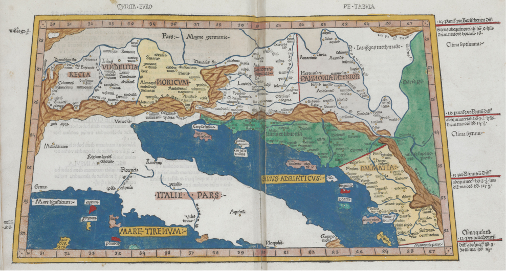
Ako se izuzme Peta karta Europe antičkoga kartografa Klaudija Ptolemeja iz 2. st., koja je za tisak priređena u više različitih inačica od 1477. (Gautier Dalché 2007) pa nije poznat nego se samo može pretpostaviti izgled otoka Korčule na toj antičkoj karti (slika 1), kontinuirano detaljnije kartografsko prikazivanje Jadrana nastupilo je s pomorskim kartama koje su se počele izrađivati najkasnije od kraja 13. st. (Campbell 1987). Na tim je kartama u fokusu bio geografski sadržaj obale kopna i otoka relevantan za planiranje i provedbu navigacijskih zadaća pa su na njima bili imenovani samo oni geografski objekti koji su se uklapali u tu sadržajnu matricu. One su sadržajno bile komplementarne portulanima (plovidbenim priručnicima) pa se za najranije takve karte koristi i naziv portulanske karte. Te karte počele su se izrađivati u razdoblju nadmetanja više jadranskih sila, prije svega Venecije i Ugarsko-hrvatskog kraljevstva, za nadmoć nad sjeveroistočnim dijelom Jadrana. Venecija je, nakon višestrukih prekida od kraja 10. st., od 1409. (na Korčuli od 1420.) utvrdila svoju vlast nad većim dijelom sjeveroistočne obale Jadrana i zadržala je na tom prostoru sve do 1797. (Vrandečić i Bertoša 2007). S ciljem kontrole i upravljanja tim područjem mletačke su vlasti započele s dokumentiranjem i kartiranjem prostornih resursa pa su uz pomorske karte izrađivane i karte koje bi se, po današnjim tipologijama karata s obzirom na njihov sadržaj, mogle svrstati u topografske karte.

Figure 1. Depiction of the island of Korčula on a version of the Fifth Map of Europe by Claudius Ptolemy - excerpt, prepared by J. Reger, Ulm, 1486 (The Renaissance Exploration Map Collection, Stanford University Libraries, Stanford, Calif.) / Slika 1. Prikaz otoka Korčule na inačici Pete karte Europe Klaudija Ptolemeja - isječak, priredio J. Reger, Ulm, 1486. (The Renaissance Exploration Map Collection, Stanford University Libraries, Stanford, Calif.)
kig-21-98-g1.jpg

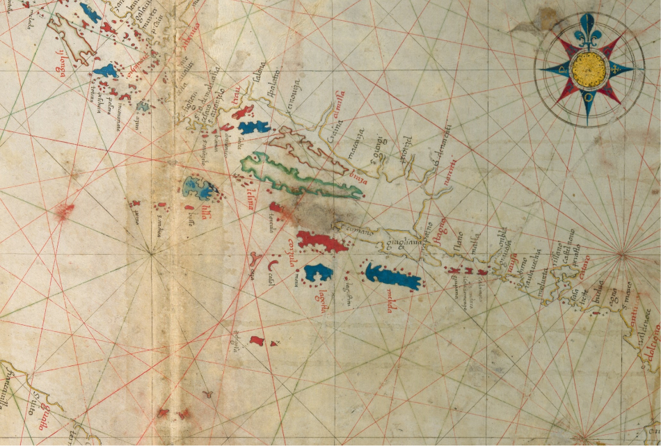
Na pomorskim kartama Jadrana otok Korčula je redovito prikazivan, a najčešće i imenovan. To je logično s obzirom na veličinu i važnost toga južnodalmatinskog otoka. Međutim, prikaz toga otoka ostao je 'zamrznut' stoljećima na preglednim pomorskim i iz njih deriviranim kartama Jadrana.[1] Otok je na karti Jadrana Pietra Vescontea (1318) imenovan kao C(o)rzola (slika 2), a na karti Jadrana Pietra Coppa (1525) kao Curzola (slika 3), što je ime koje pripada mletačkom korpusu jadranske toponimije. Pomorsko-kartografske prikaze jadranske obale, uz venecijanske i druge južnoeuropske autore, izrađivao je i Dubrovčanin Vicko Dimitrije Volčić (Vincentius Demetrius Volcius Raguseus). Na njegovoj pomorskoj karti Jadrana iz 1593. (slika 4) otok Korčula je zabilježen kao Corzula crvenom bojom, kojom je ispisao imena najvažnijih geografskih objekata na moru i kopnu (npr. imena Dubrovnika, Kotora, Stona, otoka Hvara, otoka Visa, Mljeta i Lastova), za razliku od manje važnih geografskih objekata čija je imena ispisao crnom bojom. Volčić, podrijetlom iz grada u relativnoj blizini Korčule, u prikazu obalne crte tog otoka učinio je iskorak u odnosu na starije i strane autore pomorskih karata pa se na njegovom crtežu može jasno prepoznati prostrani zaljev Vela Luke. K tome, ucrtao je mnoge otočiće i grebene u blizini Korčule dajući tako do znanja da je riječ o potencijalno opasnim objektima za plovidbu.

Figure 2. Depiction of the island of Korčula on Vesconti's map of the Adriatic - excerpt, Venice, 1311 (Österreichische Nationalbibliothek, Wien, Handschriftensammlung, Cod. 594, Tabla 11.) / Slika 2. Prikaz otoka Korčule na Vescontijevoj karti Jadrana - isječak, Venecija, 1311. (Österreichische Nationalbibliothek, Wien, Handschriftensammlung, Cod. 594, Tabla 11.)
kig-21-98-g2.jpg

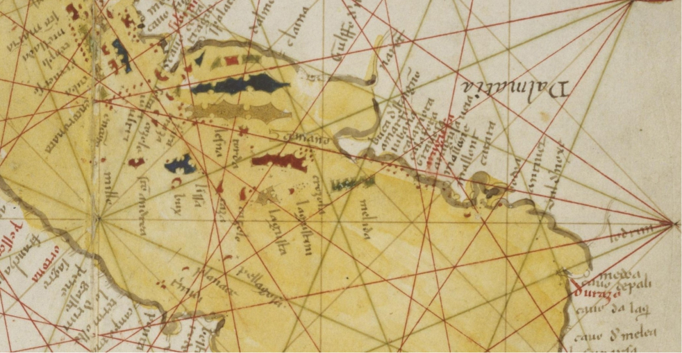
Figure 3. Depiction of the island of Korčula on Coppo's map of the Adriatic - excerpt, Venezia, 1525 (Lago, Rossit, 1984) / Slika 3. Prikaz otoka Korčule na Coppovoj karti Jadrana - isječak, Venezia, 1525. (Lago, Rossit 1984)
kig-21-98-g3.jpg

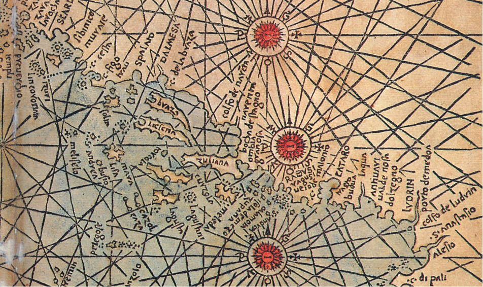
Figure 4. Depiction of the island of Korčula on Volčić's map of the Adriatic - excerpt, Naples, 1593 (National Library of Finland, the A. E. Nordenskiöld Map Collection's maps before year 1800, Sign. N_Kt_103c) / Slika 4. Prikaz otoka Korčule na Volčićevoj karti Jadrana - isječak, Napulj, 1593. (National Library of Finland, the A. E. Nordenskiöld Map Collection's maps before year 1800, Sign. N_Kt_103c)
kig-21-98-g4.jpg

Žanrovski navezani na pomorske karte i portulane bili su izolari. To su zbirke karata priobalnoga područja s pripadajućim tekstovima (ponajprije opisima otoka i luka) na kojima prevladavaju prikazi otoka (Kozličić 1995,Faričić i dr. 2020). Prvi među izolarima s prikazom hrvatskih otoka bio je Isolario nel qual si ragiona di tutte l'Isole del mondo Benedetta Bordonea, koji je tiskan u Veneciji 1528. (Kozličić 1995). U inačici Bordoneova izolara iz 1534. prikazano je više hrvatskih otoka, a među njima i Korčula. Otoci i obala prikazani su generalizirano. Na otoku je prikazano samo jedno naselje - grad Korčula (curzola), dok je među većim uvalama prikazan, ali ne i imenovan Velalučki zaljev (slika 5).

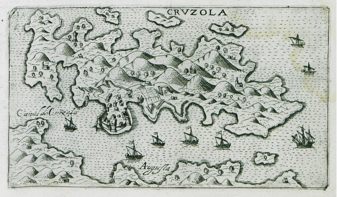
U Camociovom izolaru Isole famose porti, fortezze, e terre maritime sottoposte alla Ser.ma Sig.ria di Venetia, ad altri Principi Christiani, et al Sig.or Turco (1574), otok Korčula je prikazan s utvrđenim gradom Korčulom (CVRZOLA) koji omeđuju dvije uvale s brodogradilištima (squeri) te s kratkim opisom opsade i obrane grada Korčule od turske flote 1571. (slika 6). Na istoj su karti prikazani otoci u Pelješkom kanalu: Bobarda (ime koje se vjerojatno referira na obližnje korčulansko naselje Lumbardu), Lamadona (otočić Badija s franjevačkim samostanom), Fornase (od tal. fornace, pećnica što bi moglo označavati vapnenicu na otoku Majsanu) i Forcha (najvjerojatnije otočić Lučnjak). Prikazani su i otočići na južnoj strani otoka Korčule La lima (Mali i Veli Pržnjak, Trstenik, Gredica i Lukovac) i Carbon (Zvirinovik koji se nalazi ispred luke Karbuni). Na zapadnoj strani otoka nije upisan nijedan toponim. Grčki pomorac i kartogrtaf Antonio Millo je u svom djelu Isulario et Portolano iz 1582. otok Korčulu imenovao kao CHORCOLA, a utvrđeni grad Korčula kao churzola (slika 7). Na Millovoj karti Korčule prikazani su svi otočići kao i na Camociovoj karti Korčule, ali imenovani su samo Lamadona i Forcha te Carbon. Francuski kartograf André Thevet otok Korčulu je prikazao na karti u plovidbenom priručniku Le Grande Insulaire et Pilotage, 1586. (Faričić i dr. 2020). Thevet je otok imenovao nesonimom Isle de Cursola, a grad Korčulu ojkonimom Cursola (slika 8). Prikazao je i sve otočiće koji su prikazani na Camociovoj i Millovoj karti dok je na sjevernoj strani otoka posebno istaknuo one uvale koje su dobre za sidrenje (Bonne sonde). Kartograf Giuseppe Rosaccio u djelu Viaggio da Venetia a Costantinopoli iz 1598. otok Korčulu (CRVZOLA) prikazao je bez obližnjih otočića u Pelješkom kanalu (između otoka Korčule i poluotoka Pelješca). Taj kanal je imenovao hidronimom Canal de Curzola koji se danas odnosi na Korčulanski kanal između otoka Hvara i otoka Korčule (slika 9).

Figure 5. Depiction of the island of Korčula in Benedetto Bordoneo's isolario, Venice, 1534 (Stanford Libraries, Renaissance Exploration Map Collection, Maps and Atlases from the Renaissance Period) / Slika 5. Prikaz otoka Korčula u izolaru Benedetta Bordonea, Venecija, 1534. (Stanford Libraries, Renaissance Exploration Map Collection, Maps and Atlases from the Renaissance Period)
kig-21-98-g5.jpg

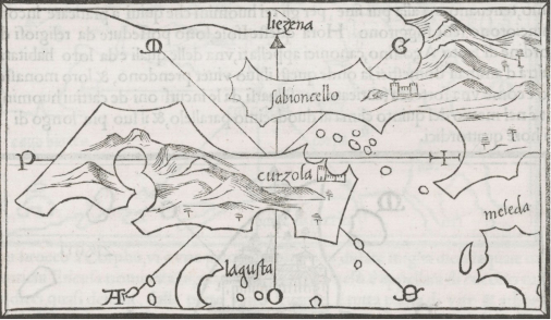
Figure 6. Depiction of the island of Korčula in Giovanni Francesco Camocio's isolario, Venice, 1574 (Historical Library, Aikaterini Laskaridis Foundation Piraeus, Travelogues - Travelers' Views) / Slika 6. Prikaz otoka Korčula u izolaru Giovannija Francesca Camocia, Venecija, 1574. (Historical Library, Aikaterini Laskaridis Foundation Piraeus, Travelogues - Travelers' Views)
kig-21-98-g6.jpg

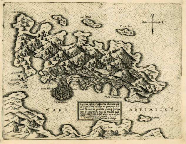
Figure 7. Depiction of the island of Korčula in Antonio Millo's isolario, Venice, 1582 (Sylvia Ioannou Foundation, Liechtenstein, Books and manuscripts, Sign. B.0254., f.21b) / Slika 7. Prikaz otoka Korčule u izolaru Antonija Milla, Venecija, 1582. (Sylvia Ioannou Foundation, Liechtenstein, Books and manuscripts, Sign. B.0254., f.21b)
kig-21-98-g7.jpg

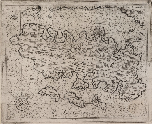
Figure 8. Depiction of the island of Korčula in Andre Thevet's isolario, Paris, 1586 (British Library, King George III's Topographical Collection, Sign. K.Top.113.46) / Slika 8. Prikaz otok Korčula u izolaru Andrea Theveta, Pariz, 1586. (British Library, King George III's Topographical Collection, Sign. K.Top.113.46)
kig-21-98-g8.jpg

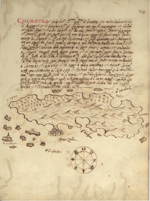
Figure 9. Depiction of the island of Korčula in Giuseppe Rosaccio's isolario, Venice, 1598 (Aikaterini Laskaridis Foundation, Piraeus, Travelogues - Travelers' Views) / Slika 9. Prikaz otoka Korčule u izolaru Giuseppea Rosaccia, Venecija, 1598. (Aikaterini Laskaridis Foundation, Piraeus, Travelogues - Travelers' Views)
kig-21-98-g9.jpg

Prevladavajuće obilježje prikaza otoka Korčule u izolarima Camocia, Milla, Theveta i Rosaccia ogleda se u deformiranosti prikaza obalne crte i oblika otoka. Prikaz istočne obale otoka Korčule tj. prostora grada (poluotoka) Korčule se redovito prostorno preuveličavao u odnosu na ostale prostorne cjeline otoka. Na taj način se vjerojatno htjela istaknuti važnost upravnog i pomorskog položaja grada Korčule. Prikaz realne izduženost otoka Korčule i zapadno-istočnog pružanja, s gradom Korčulom na istočnoj, a Velalučkim zaljevom na zapadnoj obali je u potpunosti izostao na svim kartografskim prikazima. Ta su izobličenja ponajprije posljedica slabog poznavanja geografskih obilježja prikazanog prostora i izostanka jedinstvenog linearnog mjerila (Faričić i dr. 2020). Izuzetak je Millov kartografski prikaz koji je na zapadnom kraju otoka Korčule ucrtao duboki zaljev s kaštelom i toponimom sv. Ivan (s. Zuane). Takav prikaz zapadnog dijela otoka donekle reflektira stvarno stanje jer su se u Velalučkom zaljevu u 16. st. nalazila četiri kaštela korčulanskih plemića te crkvice sv. Vicenca i sv. Ivana u Gradini (Maričić 1997).

U razmatranju otoka i grada Korčule potrebno je istaknuti još jednu specifičnost. Naime, tijekom srednjega i ranoga novog vijeka grad Korčula je imao veliku važnost. Povoljan geoprometni položaj grada i Pelješkog kanala rezultirao je kartografskim ostvarenjima s naglašenim prikazima istočnog dijela otoka Korčule. Za razliku od istočnog dijela otoka koji je umnogome bio obilježen urbanim i pomorskim funkcijama grada Korčule, zapadni dio otoka bio je agrarni prostor izrazito ruralnih obilježja. Na tom dijelu otoka poljoprivreda je bila glavna gospodarska djelatnost koja se razvijala na relativno velikim agrarnim površinama koje su pripadale Blatu (Campi Blatta). U središnjem dijelu otoka bila su polja koja su pripadala Smokvici (Campus Smoquize) i Čari (Campus Magnus Carre) dok je na istočnom dijelu otoku bio tek manji broj polja i to u Lumbardi (Campus Lombarde) i Žrnovu (Campus Zernove). U okolici grada Korčule nije ih bilo (Dokoza 2009). Takva geomorfološka obilježja utjecala su na razmještaj i razvoj naselja. Pogodnost geografskog položaja Blata zasnivala se na smještaju uz najznačajnije otočne agrarne površine, ali i udaljenošću od mora i okruženošću uzvisinama, a s time i zaštićenošću od napada gusara i pirata. Blato na najstarijim prikazima otoka Korčule nije bilo kartirano, zacijelo ponajprije zbog toga što su oni bili usmjereni na prikaz obalnog prostora. Istodobno, na kartama Korčule objavljenim u izolarima na zapadnoj obali tog otoka nije imenovan ni najveći otočni zaljev, Velalučki zaljev, već uvale ispred otočića La lima i Carbona na južnoj obali otoka. To je posljedica unutarotočne prometne povezanosti odnosno činjenice da Velalučki zaljev - iako sigurno sidrište - nije bio u upotrebi već je jedina izvozna luka otoka bila Korčula. Transport poljoprivrednih proizvoda sa zapadnog dijela otoka do grada Korčule išao je preko luka Prigradice i Prižbe. Naime, grad Korčula je ovisio o uvozu žita iz Sicilije i južne Italije, međutim ta ovisnost je dijelom ublažavana proizvodnjom žitarica, osobito ječma, na blatskim poljima (Dokoza 2003).

3.2. Kartografski prikaz otoka Korčule nepoznatog autora iz Archivio do Stato di Venezia

Dok su geografski sadržaji zapadnog dijela otoka Korčule na pomorskim kartama uglavnom izostavljeni, u tome pogledu mnogo je bogatija karta otoka Korčule nepoznatog kartografa iz Archivio do Stato di Venezia. U tom se arhivu karta datira u drugu polovicu 16. st., ali niti jedan podatak na karti nas nije naveo da potvrdimo ili odbacimo takva dataciju. K tome, uz kartu nije vezan niti jedan poznati dokument (ili ga mi našim propustom nismo pronašli) pa nisu jasne ni okolnosti njezina nastanka. Nažalost, karta je vrlo oštećena na dijelu u kojem se nalazi kartuša s tekstom. Sačuvani dio teksta nema niti jednu riječ koja bi upućivala na autora, okolnosti i vrijeme nastanka karte. Skloni smo, stoga, dataciju ipak postaviti šire pa pretpostaviti da je karta nastala ili u drugoj polovici 16. ili u prvoj polovici 17. st. Naime, žanrovskih analogija toj rukopisnoj karti Korčule nema u 16 st., dok iz prve polovine 17. st. potječu detaljniji prikazi pojedinih hrvatskih otoka ili dijelova otoka pod mletačkom upravom kao što je, primjerice, Garsoganijeva karta Sutomišćice na otoku Ugljanu iz 1610., najstarija rukopisna karta iz zbirke Mape Grimani Državnoga arhiva u Zadru (Faričić 2022).

Za razliku od karata u izolarima koje su bile tiskane i imale su veći odjek, a zasigurno i širu korisničku publiku, rukopisna karta otoka Korčule bila je čuvana u nekom od ureda mletačke državne administracije i nije bila poznata tadašnjoj široj geografsko-kartografskoj zajednici. Zbog toga je njezina komunikacijska uloga nažalost uokvirena unutar mletačke administracije. Tijekom ranoga novog vijeka isti je slučaj bio i s drugim rukopisnim kartama manjih prostornih cjelina koje, jer su bile namijenjene za uvid u prostorne resurse ili za utvrđivanje zemljišno-imovinskih odnosa za koje je bio zainteresiran manji broj službenika i zemljoposjednika, nisu bile javno dostupne, pa stoga nisu mogle poslužiti kao izvor prostornih podataka prilikom izrade tiskanih karata većih prostornih cjelina.

Na polju karte posebno je istaknut zapadni dio otoka Korčule i njegove poljoprivredne površine (slika 10). Posebno je zanimljiva pozornost koja je usmjerena prema Velalučkom zaljevu (Valle Grande) i mnogim toponimima unutar zaljeva (Vranaz, Tudoroviza, Privala, Cursar, Valle Bobovischia, Valle Gabriiza i Piscena Paricolar ) koji se i danas koriste kao imena uvala. Unutar zaljeva imenovan je i poluotočić Sv. Ivan (S. Giovanni) s crkvom te otočići Ošjak (scoglio Osciak) i Proizd (Proisd scoglio ). U dnu Velalučkog zaljeva tada nije postojalo naselje već samo četiri kaštela korčulanskih plemića (Izmaeli, Gabrijelić, Nikoničić i Kanavelić) te crkvice sv. Vicenza i sv. Ivana u uvali Gradina (Maričić 1997). Svi navedeni objekti su ucrtani na kartografskom prikazu, osim crkvice sv. Vicenca u neposrednoj blizini kaštela.

Figure 10. Depiction of the island of Korčula by an unknown author, second half of the 16th century - first half of the 17th century (Archivio di Stato di Venezia, Miscellanea Mappe, Sign. 36) / Slika 10. Prikaz otoka Korčule nepoznatog autora, druga polovica 16. stoljeća - prva polovica 17. stoljeća (Archivio di Stato di Venezia, Miscellanea Mappe, Sign. 36)
kig-21-98-g10.jpg

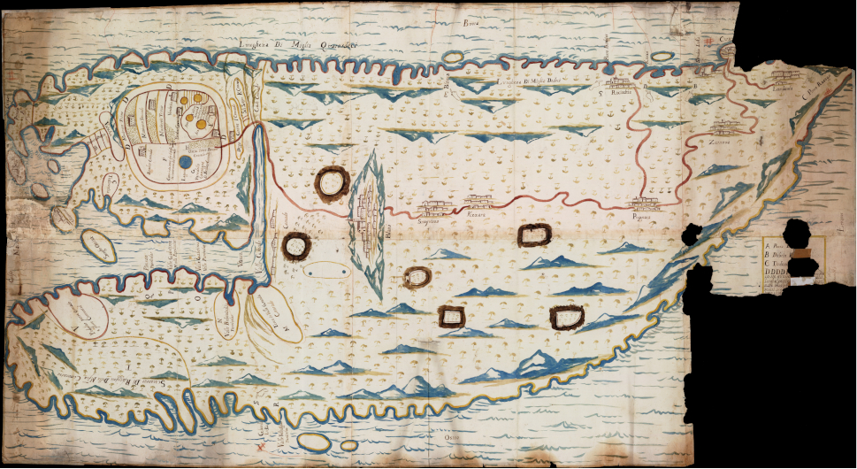
Osim u obalnom prostoru, toponimija je bogata i u agrarnom prostoru Bradata (Bradar Conrado) s istaknutom lokvom dok su ostale agrarne površine označene znakom kvadratića. Razmještaj kvadratića u okolici Blata, Smokvice i Čare odgovara agrarno najznačajnijim površinama na otoku. Iako je zapadni dio otoka bio u fokusu nepoznatog autora, on ne ističe, kako bi se očekivalo, u prvi plan agrarno najznačajnija blatska polja. Naime, na zapadu otoka Korčule agrarnu okosnicu razvoja su činili Blatsko polje - Donje blato, te Potirna, ali poljoprivredna proizvodnja bila je disperzirana na svim poljima ili blagim padinama zapadnog dijela otoka. Uz agrarnu, prednost polja Bradat je bio i geografski položaj. Polje je bilo smješteno u sjevernom dijelu Velalučkog zaljeva i imalo je neposredan izlaz na zaljev ili lučicu Gradinu sv. Ivana koja je bila u potpunosti zaklonjeno sidrište. Uvala Gradina od prapovijesti je bila važna kao točka dodira na plovidbenom putu koji povezuje istočnu i zapadnu obalu Jadrana putem tzv. otočnog mosta Gargano - Tremiti - Palagruža - Sušac - Korčula - Hvar - Neretva. Tu povezanost potvrđuje i antička villa rustica u istočnom dijelu polja Bradat tj. zaobalju Gradine preko koje je komunicirala što dokazuje i rimski pristan na sjeverozapadnom dijelu uvale (Borzić 2009). Gradina sv. Ivana imala je i vojnu važnost u pogledu nadzora ulaska u Velalalučki zaljev, ali i nad Viškim kanalom.

Na temelju povijesnih toponima iz malobrojne arhivske građe moguća je, u usporedbi s prikazom na karti iz Venecije, rekonstrukcija agrarnog krajolika. Među spomenutim lokalitetima ističu se Gradina i Bradat, koji se navode u dokumentima o podjeli kneževe zemlje 1411. godine.[2] Polje Bradat spominje se nekoliko puta i u drugim arhivskim dokumentima, kao i njegovi manji dijelovi Bradat stup i Zabradat. Često imenovanje Bradata, ali i manjih prostornih jedinica u arhivskim izvorima upućuje na agrarnu važnosti tog polja. To potvrđuje i vlasništvo nekoliko korčulanskih plemića nad zemljišnim parcelama u tom polju (Dokoza 2022).

Na kartografskom prikazu uz grad Korčulu i njezin uobičajeni panoramski prikaz imenovana su i sva otočna naselja (Blatta, Smogvirza, Kzzara, Pupnara, Zernova, Racischia, Lombarda i Curzola) koja su prikazana stiliziranim crtežom. Pri tome je posebno zanimljiv prikaz Blata koji jasno odražava percepciju naselja kao demografskog i agrarnog središta otoka u ranom novom vijeku.

Zanimljiv kartografski element na karti su manicule[3] koje upućuju korisnika na pet otočnih uvala. To su uvala Grdača (Grherda) na južnoj strani otoka, te uvale Blaca (Blazza), Vaja ili Samograd (Porto Barbier), Kneža (Knexa) i najvjerojatnije Žrnovska banja (Sirechia Luka) na sjevernoj strani otoka Korčule. Teško je odrediti zašto su te luke dodatno istaknute kartografskim znakom male ruke. Može se pretpostaviti da je namjera nepoznatog autora bila istaknuti ključne luke za unutarotočnu pomorsku komunikaciju, odnosno luke koje su povezivale grad Korčulu s ostatkom otoka.

Kartografski prikaz otoka Korčule izdvaja se među dosadašnjim poznatim i dostupnim kartografskim prikazima otoka. Naime, svi drugi prikazi tog otoka, uglavnom mletačkih, ali i drugih europskih autora, sadržajno su se podudarali. U pravilu su zadržavali isti obalni prikaz s isticanjem grada Korčule i Pelješkog kanala afirmirajući upravno značenje grada, ali i važnost otoka u pomorsko-geografskom sustavu Jadrana i Sredozemlja.

Kako je već istaknuto, mletačka uprava nad većim dijelom sjeveroistočne obale Jadrana zahtijevala je i veći angažman venecijanskih vlasti oko kartiranja jadranskih prostornih resursa. S obzirom na prevladavajuće uopćene prikaze Korčule na kartama Jadrana, najvjerojatnije je i karta nepoznatog autora nastala kao odraz težnji mletačkih vlasti za detaljnijim kartiranjem otočnog prostora koji do tada bio poznat samo u osnovnim crtama.

3.3. Kartografski prikazi otoka Korčule tijekom 17. i 18. stoljeća

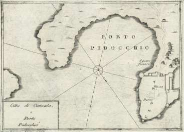
Mletački interes za kartografskim prikazom sjeveroistočne obale Jadrana dodatno je osnažen političkim okolnostima u 17. i početkom 18. st. Veći dio današnje Hrvatske bio je ustrojen kao pogranični prostor imperijalnih sila Habsburške Monarhije, Osmanskog Carstva i Mletačke Republike. U tom razdoblju došlo je do tri rata između Venecije i Osmanskog Carstva - Kandijski rat (1645-1669), Morejski rat (1684-1699) i Drugi morejski rat (1714-1718). Tijekom tih ratova Venecija je izgubila svoje posjede po kojima su ti ratovi nazvani (Kandija - Kreta i Moreja - Peloponez), ali je znatno proširila svoj posjed u zaobalju sjeveroistočne obale Jadrana. U tom kontekstu Venecija je nastojala dobiti što preciznije kartografske prikaze starih i novih stečevina svog prekomorskog posjeda na Jadranu (Mayhew 2008). U kvaliteti prikazivanja današnjega hrvatskog primorskog prostora istaknuo se mletački kartograf Vincenzo Maria Coronelli koji je izradio više desetaka karata s prikazima pojedinih dijelova jadranskoga priobalnog pojasa. Prikaz socio-geografskih sadržaja otoka Korčule Coronelli je dao na karti Dubrovačke Republike koja je objavljena u Veneciji 1688. (Stato di Ragusi Bocca del Fiume Narenta, Isole di Lesina e Curzola nella Dalmatia prosedutte Dalla Serenissima Republica di Venetia)(slika 11). Na južnoj strani otoka prikazana je uvala Karbuni (Carbone) uz napomenu da je pogodna za sve vrste brodova, a dodatno je točkastom crtom i slovom d označena plovidbena ruta između otočića Zvirinovika i Obljaka. Na sjevernoj strani otoka prikazane su i opisane uvale Blaca (Blazza) kao luka pogodna za manje brodove tj. barke, uvala Rašišće (Rachisca) kao luka koja nije pogodna za sidrenje u slučaju da pušu bura (Greco) i sjevernjak (Tramonta) te Žrnovska banja (Bagna) kao luka dobra za sve vrste brodova. Na zapadnom dijelu otoka u trima lukama su označena skladišta usoljenih srdela i vina i to u Velalučkom zaljevu (Magazzini da Sardelle e Vino) te u uvalama Triporte i Prigradica (Magazzini). U prikazivanju istočnog dijela otoka Coronelli nije donio značajnijih novosti. Detaljniji prikaz grada Korčule (slika 12 i13) objavljen je u njegovoj zbirci karata, planova i veduta Mari, Golfi, Isole, Spiaggie, Porti, Citta, Fortezze, ed altri Luoghi Dell' Istria, Quarner, Dalmazia, Albania, Epiro, e Livadia u Veneciji 1694. Na njima je istaknuta luka Pidocchio[4] i podatak o dubini Pelješkog kanala: Canal di Curzola fondo 20 e 24 passi[5], te brodogradilište za koje je upisano da je 'čuveno, cijenjeno' (squero famoso), čime je za razliku od Camocija koji je također prikazao korčulanske škverove, dao dodatnu kvalitativnu oznaku za tu gospodarsku djelatnost.

Figure 11. Coronelli's depiction of the island of Korčula on a map of the Dubrovnik Republic - excerpt, Venice, 1688 (Library of State Archives in Zadar, Zadar, Sign. II. A*) / Slika 11. Coronellijev prikaz otoka Korčule na karti Dubrovačke Republike - isječak, Venecija, 1688. (Državni arhiv u Zadru, Zadar /dalje HR-DAZD/, Knjižnica, Sign. II. A*)
kig-21-98-g11.jpg

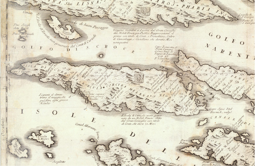
Figure 12. Map of the Korčula and Pešeljac Channel area, Venice, 1694 (Library of State Archives in Zadar, Zadar, Sign. II. A*) / Slika 12. Karta užeg područja Korčule i Pelješkog kanala, Venecija, 1694. (HR-DAZD Knjižnica, Sign. II. A*)
kig-21-98-g12.jpg

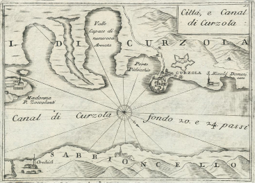
Figure 13. Coronelli's map fo the city of Korčula, Venice, 1694 (Library of State Archives in Zadar, Zadar, Sign. II. A*) / Slika 13. Coronellijev plan grada Korčule, Venecija, 1694. (HR-DAZD, Knjižnica, Sign. II. A*)
kig-21-98-g13.jpg

Coronelli je poopćene prikaze grada Korčule dao i na drugim kartama. Na karti Dalmacije iz 1694. godine označene su granice dalmatinskih okruga (contadi) na kopnu i na moru (slika 14), te godine mletačkog zauzeća pojedinih obalnih i otočnih komuna. Unutar Korčulanskog okruga koji je uspostavila mletačka vlast 1420. godine (Dokoza 2009) uz otok Korčulu i pripadajuće otočiće Coronelli je obuhvatio i otok Šćedro (Isola di Torcola). Naveo je da su Mlečani zauzeli Korčulu 992., a zatim ponovno 1420. Uz uvale na zapadnom dijelu otoka označio je skladišta (Magazzin, Magazzini da Sardelle i Magazzini) što upućuje na gospodarsko značenje tog dijela otoka. Za naselje Blato uz ojkonim je istaknuta i veličina naselja (Blatta Villa grossa di 200 casa). Coronelli je, kao i autori karata u izolarima, istaknuo važnost otočnih luka i to na južnoj obali otoka (Carboni, Tre Porte) uz bilješku da su te luke dobre za sve vrste brodova.

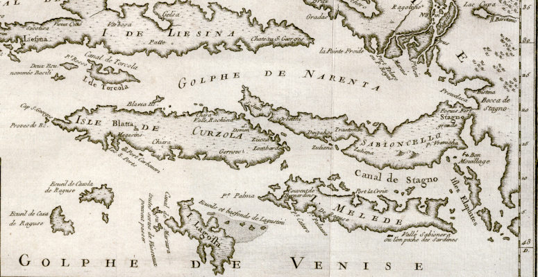
Tijekom 18. stoljeća Coronellijeva geografska građa je kod mnogih europskih kartografa prihvaćena kao predložak za različite reprodukcije prikaza Jadrana. Coronellijev utjecaj zadržan je i kod prikaza Korčule, što se, uz ostalo, vidi i na kartama francuskog hidrografa i kartografa Jacquesa Nicolasa Bellina. Zanimljiv je njegov odabir korčulanskih toponima na karti Jadrana iz 1771. godine (slika 15). Uz ime otoka istaknuo je pripadnost otoka Veneciji (I DE CURZOLA aux Venitiens). Iako je riječ o pomorskoj karti, Bellin je korisnicima dao i relevantne političko-geografske informacije približavajući im političke odnose na Jadranu. U ovom slučaju Bellinova je namjera bila razgraničiti teritorij između dviju Republika pa je tako otok Korčula označen kao mletački, a otok Mljet kao dubrovački posjed. Bellin je posebno imenovao Blato (Blatta) koje je prikazano s crkvom te Lumbardu (Lombara) i Čaru (Chiara). Od hidrografskih elemenata označena su sidrišta na zapadnoj strani otoka - Velalučki zaljev i luka Tri porte (Les trois Ports bons pour tous Vaiβeaux) na jugozapadnoj obali, koja je, Coronellijevim tragom, opisana kao dobra luka za sve brodove. Na istočnoj obali je istaknuto sidrište u Pelješkom kanalu te na sjevernoj obali u uvali Kneža ili Žrnovska banja. Zanimljivo je, međutim, da Bellin na karti Jadrana nije prikazao grad Korčulu. Štoviše, to nije učinio ni na karti dijela dalmatinske obale od Rogoznice do Stona (Coste de Dalmatie entre Ragoniza et Stagno) na kojoj je dao detaljniji prikaz otoka Korčule (slika 16) poput onoga koji se nalazi na Coronellijevoj karti Dalmacije. To je primjer kako je kartografska generalizacija nedovoljno upućenoga kartografa „pomela“ važan geografski sadržaj.

Figure 14. Coronelli's depiction of the island of Korčula on a map of Dalmatia - excerpt, Venice, 1694 (Library of State Archives in Zadar, Zadar, Sign. II. A*) / Slika 14. Coronellijev prikaz otoka Korčule na karti Dalmacije - isječak, Venecija, 1694. (HR-DAZD, Knjižnica, sign. II. A*)
kig-21-98-g14.jpg

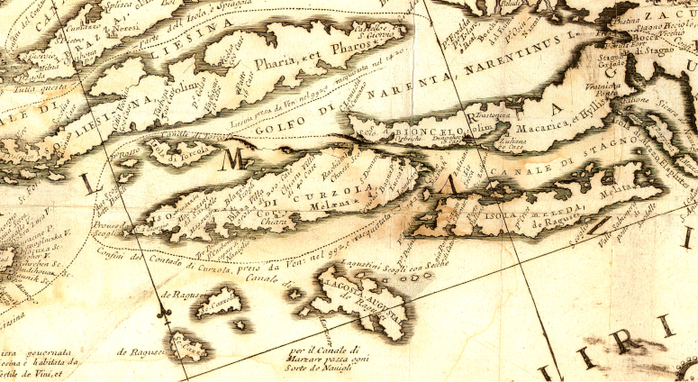
Figure 15. Depiction of the island of Korčula on a map of the Adriatic -by Jacques Nicolas Bellin - excerpt, Paris, 1771, (National and University Library, Atlas and Map Collection, NSK-SJZXVIII-145_001) / Slika 15. Prikaz otoka Korčule na karti Jadrana Jacquesa Nicolasa Bellina - isječak, Paris, 1771. (Nacionalna i sveučilišna knjižnica, Zbirka atlasa i zemljovida, NSK-SJZXVIII-145_001)
kig-21-98-g15.jpg

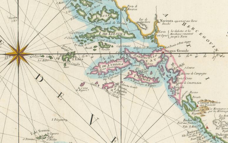
Figure 16. The island of Korčula on Bellin's map of the central part of the Dalmatian coast - excerpt, Paris, 1771 (University of Split Library, Split, Map collection, R-684) / Slika 16. Otok Korčula na Bellinovoj karti srednjeg dijela dalmatinske obale - isječak, Paris, 1771. (SKST, Kartografska zbirka, R-684)
kig-21-98-g16.jpg

Coronellijev geografski sadržaj nije bio jedini predložak koji je poslužio za mnoge kasnije nekritičke, a kadšto i nekvalitetne reprodukcije. Naime, odvojeno od koronelijanskog niza karata razvijao se jedan drugi osamnaestostoljetni dijakronijski reprodukcijski niz. Mletačke su vlasti poslije ratova s kraja 17. i početkom 18. st. organizirale izradu korografskih, odnosno topografskih karta Dalmacije. Izradi tih karata nisu prethodile sustavne geodetske izmjere premda su mjernički postupci bili provedeni s ciljem određivanja, a zatim i iscrtavanja novih mletačko-habsburško-osmanskih granica. Na tim korografskim kartama uspostavljen je geografsko-kartografski obrazac koji se, uz onaj Coronellijev, zadržao se sve do kraja 18., odnosno do početka 19. st. kada već anakroni korpus geografskih podataka postupno zamjenjuje sadržaj topografskih i pomorskih karata koje su nastale kao rezultat topografske i hidrografske izmjere današnjega primorskog dijela Hrvatske (Faričić 2011,2017;Kozličić i Faričić 2016). U pogledu prikaza otoka Korčule na korografskoj karti Dalmacije, koju je u Zadru oko 1718. izradio nepoznati autor (možda Francesco Melchiori koji je tada bio istaknuti kartograf u službi mletačke uprave u Dalmaciji), razlikuje se od Coronellijevih karata po mnogo boljem prikazu obalne crte te imenovanjem pojedinih manjih uvala i otočića na južnoj (Trastenich, Bercich, Trepozzi, Porto Simon, Chandria vala, Rocotniza, Perina vala) i sjevernoj (Rachisca vala, Rasohattiza) obali otoka. Od krajnjih geografskih točki otoka imenovani su na zapadnom dijelu otočić Čančir (Cao Cancara) i rt Kursar (Cao S. Zorzi), a na istoku rt Ražanj (Cao Rasagn) (slika 17). Međutim, neki drugi elementi preuzeti su od Coronellija poput antičkog imena otoka i prikaza administrativnih granica Korčule s godinama mletačkog zauzeća tog otoka (ali tim granicama nije obuhvaćeno Šćedro).

Napredak u prikazu Korčule zabilježen je kod Giuseppea A. Grandisa, koji je koristeći geografski sadržaj s topografske karte iz 1718., ipak obavio odgovarajuće izmjene i dopune na rukopisnoj topografskoj karti Dissegno o' carta topografica della Dalmazia koju je izradio u Zadru 1781. Na toj karti prikaz otoka Korčule je realniji zbog preciznijeg prikaza obalne crte, te prikaza reljefa crtkanjem pri čemu je Grandis gušćim crticama prikazao veće nagiba padina, a rjeđim crticama padine s manjih nagibom. Od otočnih naselja prikazana su (imenovana i označena kartografskim znakom crvene boje) uglavnom obalna naselja odnosno uvale koje su bitne za pomorsku komunikaciju. Žarišta naseljenosti u unutrašnjosti otoka Blato i Smokvica, pa i Lumbarda koja je na obali, nisu prikazana na toj Grandisovoj karti kao ni na karti Dalmacije iz 1718. Iako je Grandis svoj kartografski prikaz u usporedbi s kartom iz 1718. dopunio toponimima Tankaraca (Tremuli), Prapatna (Prapadna) i Bristva (Brista) na sjevernoj obali otoka, a na južnoj uvalom Brna (Porto Berno) (slika 18), ostao je unutar metodološkog obrasca u kojemu je zanemarena unutrašnjost otoka.

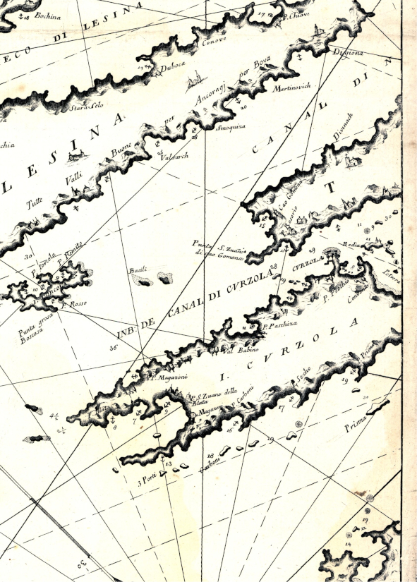
Posljednji ranonovovjekovni kartografski prikaz otoka Korčule je onaj Vincenza di Lucija koji je oko 1790. izradio kartu Jadrana u više listova, među kojima je i list s prikazom otoka i akvatorija kojima pripada i Korčula. Kartografski prikaz Vincenza de Lucija u pogledu prikaza Korčule ipak ne donosi nikakvu novost (slika 19). Na tom prikazu otoka Korčule (I. CVRZOLA) može se primijetiti isticanje toponima na zapadnoj obali otoka. Uz već ustaljene na geografskim kartama (3 Porti, Carboni, Magazeni, P. Magazeni), na toj su pomorskoj karti upisani i toponimi P. Blata i P. S. Zuane della Blatta. Toponim P. Blata odnosi se na krajnji zapadni dio Velalučkog zaljeva tj. prostor Privale. Drugi toponim P. S. Zuane della Blatta upisan je u dnu Velalučkog zaljeva i teško je odrediti na koji dio obale se odnosi. Naime, u zapadnom dijelu otoka nalaze se dvije crkve posvećene sv. Ivanu. Jedna je crkvica posvećena sv. Ivanu Krstitelju u uvali Gradina, a druga je posvećena sv. Ivanu Evanđelistu i nalazi se u naselju Blatu. Imenovanje krajnjeg zapadnog dijela otoka tj. punte Privala s P. Blata upućuje na upravno-teritorijalnu aktualnost, odnosno postupnu litoralizaciju naselja Blata u kojem Velalučki zaljev postaje funkcionalni dio Blata što je u konačnici dovelo do oblikovanja novog naselja Vela Luke.

Figure 17. Depiction of the island of Korčula on a map of Dalmatia by an unknown author - excerpt, Zadar, around 1718 (HR-DAZD-383, State Archives in Zadar, Map collection, Sign. 1.3.1). / Slika 17. Prikaz otoka Korčule na karti Dalmacije nepoznatog autora - isječak, Zadar, oko 1718. (HR-DAZD-383, Kartografska zbirka, Sign. 1.3.1).
kig-21-98-g17.jpg

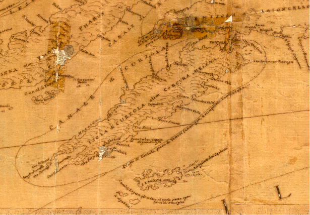
Figure 18. Depiction of the island of Korčula on Giuseppe Antonio Grandis's map - excerpt, Zadar, 1781 (HR-DAZD-383, State Archives in Zadar, Map collection, Sign 1.3.3) / Slika 18. Prikaz otoka Korčule na karti Giuseppea Antonija Grandisa - isječak, Zadar, 1781. (HR-DAZD-383, Kartografska zbirka, Sign 1.3.3)
kig-21-98-g18.jpg

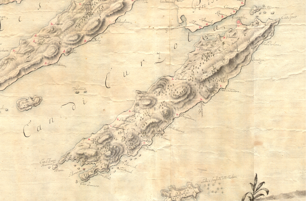
Figure 19. The island of Korčula on a cartographic depiction of the Adriatic by Vincenzo de Lucio - excerpt, Venice, around 1790 (Croatian State Archives, Map collection, E.IV.13.) / Slika 19. Otok Korčula na kartografskom prikazu Jadrana Vincenza de Lucija - isječak, Venecija, oko 1790. (Hrvatski državni arhiv, Kartografska zbirka, E.IV.13.)
kig-21-98-g19.jpg

Zaključak

Na temelju istraživanja odabranih kartografskih izvora utvrđeno je da su kvaliteta geografskog sadržaja, uz ostalo broj i obilježja toponima otoka Korčule, susjednih otočića i pripadajućeg akvatorija uglavnom ovisili o vrsti karte, njezinom mjerilu i stupnju geografskih spoznaja o tom hrvatskom otoku. Interes za kartografiranjem obalnog prostora proizlazio je iz geostrateških, odnosno političkih interesa europskih sila, u prvom redu Venecije. Odabrani primjeri geografskih i pomorskih karata potvrđuju taj interes. To su pregledne karte Jadrana i Sredozemlja na kojima je otok Korčula redovito prikazivan iako shematizirano bez detaljnih informacija i opisa obale na kartografskim prikazima. Na tim kartama najčešće je zabilježeno ime otoka i/ili ime grada Korčule što je uz nedovoljno geografsko poznavanje kartiranog prostora zasigurno bilo uvjetovano i mjerilom te dimenzijama karte koji su posljedično utjecali na stupanj generalizacije i nedostatak raspoloživog prostora za pisanje geografskih imena.

Detaljniji kartografski prikazi otoka Korčule objavljeni su u izolarima koji, uz već uobičajeni prikaz otoka i toponima, sadrže i prikaz otočića u Pelješkom kanalu. Činjenica da je Korčula u izolarima prikazivana na posebnim kartama upućuje na važnost tog otoka na sjeveroistočnom jadranskom pomorskom pravcu.

Najdetaljniji i najcjelovitiji prikaz otoka Korčule je karta krupnog mjerila nepoznatog autora iz druge polovice 16. st. ili prve polovice 17. st. S obzirom na geografski sadržaj karte, najvjerojatnije je izrađena po nalogu venecijanskih vlasti s namjerom evidentiranja, odnosno prikupljanja preciznijih prostornih podataka, uglavnom onih ekonomsko-geografskog sadržaja o krajnjem zapadnom dijelu otoku.

Značajniji iskorak u kvaliteti prikaza otoka Korčule započeo je mletački kartograf Coronelli krajem 17. st. On je uspostavio svojevrsni geografsko-kartografski obrazac koji se, poput onoga vezanog uz mletačko kartiranje Dalmacije poslije Morejskoga i Drugoga Morejskog rata, zadržao sve do kraja 18. odnosno do početka 19. stoljeća kada su se topografske (i na njima utemeljene tematske) karte i pomorske karte počele izrađivati kao rezultat sustavnih i znanstveno utemeljenih izmjera. Posljednji među detaljnijim ranonovovjekovnim kartografskim prikazima jest de Lucijeva pomorska karta Jadrana na kojoj, međutim, otok Korčula nije prikazan ništa bolje od prikaza na topografskim kartama Dalmacije koje su joj neposredno prethodile. Na tim su kartama autori dali naglasak na prikaz reljefa i otočnih naselja, a rjeđe i na neke ekonomsko-geografske sadržaje (primjerice, brodogradilište u gradu Korčuli). S obzirom na to da je mjerilo tih karata bilo krupnije u odnosu na kartografska ostvarenja iz 16. i većeg dijela 17. st., na njima je ispisano i više geografskih imena. Uz mletačke toponime povezane uz veća naselja i važnije rtove i luke koji su se postupno uvriježili kao standardni jezično-geografski korpus geografskih i pomorskih karata, zapisana su i hrvatska (slavenska) geografska imena, za koja očito nisu postojala alternativna mletačka jezična rješenja. Naime, na kartama krupnijeg mjerila i većih dimenzija bilo je moguće prikazati mnogo više geografskih objekata, pa je pod 'povećalo' kartografa došao dotad nepoznati geografski sadržaj čiji je sastavni dio i hrvatska toponimija.

Napomena

Ovaj je rad rezultat istraživanja provedenih u sklopu znanstvenog projekta IP-2020-02-5339 Ranonovovjekovne pomorske karte Jadranskog mora: izvor spoznaja, sredstvo navigacije i medij komunikacije koji financira Hrvatska zaklada za znanost.

Notes

[1] After the Treaty of Zadar in 1358, the rule of the Zorzi family over Korčula and the conflicts with their dukes over property on the island ended. The Korčula Grand Council made a decision in 1409 to divide the former duke's land between nobles and commoners, which was done in the Agreement on the Division of Land in 1411. (Foretić 1940).

[2] Manicules are one of the most common symbols that readers wrote in the margins of manuscripts and/or publishers inserted into printed books in the period from the 12th to the 18th century. This small hand with the extended index finger was primarily used to indicate a particularly important passage of text (Sherman 2010).

[3] The geographical name of the Korčula port Pidocchio is associated with the piloting of ships in and out of the port. The 1272 Dubrovnik code uses the terms pedochya, pedocia, peđotla (Gjivoje 1969).

[4] Given that one Venetian fathom (passo veneto) was 1.738562 m long (Herkov 1977, 147), this would mean that the depths in the Pelješac Channel were between 35 m and 42 m. In the narrowest parts of that channel between the town of Korčula and Pelješac and between the islets of Veli Kneža and Pelješac, the depths are indeed approximately in that range, while in other parts they are greater (as can be determined by verifying contemporary nautical charts and topographic maps of the Republic of Croatia).

[1] O točnosti pomorskih karata Jadrana od 13. do 16 st. doktorski rad objavio jeT. Marelić (2020).

[2] Nakon Zadarskog mira 1358. prestala je vlast porodice Zorzi nad Korčulom i sukobi s njihovim kneževima oko posjeda na otoku. Korčulansko veliko vijeće donijelo je odluku 1409. godine da se nekadašnja kneževa zemlja podjeli između plemića i pučana što je i učinjeno Ugovorom o podjeli zemlje 1411. godine (Foretić 1940).

[3] Manicule je jedan od najčešćih simbola koje su čitatelji upisivali na margine rukopisa i/ili umetali izdavači u tiskane knjige u razdoblju od 12. do 18. stoljeća. Takva mala ruka s ispruženim kažiprstom prvenstveno se koristila za označavanje posebno važnog odlomka teksta (Sherman 2010).

[4] Geografsko ime korčulanske luke Pidocchio dovodi se u vezu s peljarenjem brodova u luku i iz nje tj. u dubrovačkom zakoniku iz 1272. peljarenje se naziva pedochya, pedocia, peđotla (Gjivoje 1969).

[5] S obzirom na to da je jedan mletački hvat (passo veneto) bio dug 17,738562 m (Herkov 1977, 147), to bi značilo da su dubine u Pelješkom kanalu između 35 m i 42 m. Na najužim dijelovima tog kanala između grada Korčule i Pelješca te između otočića Veli Kneža i Pelješca dubine su doista približno u tom rasponu, dok su u drugim dijelovima veće (kako je to moguće utvrditi uvidom u suvremene pomorske i topografske karte Republike Hrvatske).