License (open-access, http://creativecommons.org/licenses/by-sa/4.0/):
CC-BY-SA
License (open-access):
Prava korištenja: CC-BY-SA
License (open-access):
Journal content is published under CC-BY-SA licence.
Publication date: 2023
Volume: 22
Issue: 39
News
Glavačeva karta Hrvatske
Emilia Domazet
; Hrvatski državni arhiv, Metropolitanska knjižnica Zagrebačke nadbiskupije Zagreb
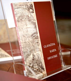
Hrvatski državni arhiv objavio je 2023. godine zbornik radova Glavačeva karta Hrvatske, ISBN 978-953-8461-06-4, 143 stranice. Urednica zbornika je Emilia Domazet, knjižničarka Metropolitanske knjižnice pri Hrvatskom državnom arhivu. Zbornik je nastao kao plod znanstvenog skupa i istoimene izložbe Glavačeva karta Hrvatske, održanog 16. rujna 2021. u organizaciji Metropolitanske knjižnice Zagrebačke nadbiskupije i Hrvatskoga državnog arhiva.
Glavačeva karta; zbornik radova; Hrvatski državni arhiv; Metropolitanska knjižnica
306274
28.4.2023.
![]()
Visits: 1.691 *
In 2023, the Croatian State Archives published the Proceedings titled Glavačeva karta Hrvatske (Glavač’s Map of Croatia), ISBN 978-953-8461-06-4, 143 pages. The editor of the Proceedings is Emilia Domazet, librarian of the Metropolitan Library at the Croatian State Archives. The Proceedings were created as a result of the scientific conference and exhibition of the same name, Glavač's Map of Croatia, held on 16 September 2021, organized by the Metropolitan Library of the Zagreb Archdiocese and the Croatian State Archives. Given that Stjepan Glavač was a Jesuit and the first professor of philosophy at the Jesuit Academy in Zagreb, the foreword was signed by Assist. Prof. Dalibor Renić PhD, Provincial of the Croatian Province of the Society of Jesus. The Proceedings were proofread by Tomislav Salopek, and the summary translated into English by Marijan Bosnar, archival consultant. The Proceedings were reviewed by Prof. Damir Hasenay PhD from the Faculty of Humanities of the Josip Juraj Strossmayer University in Osijek and Martina Triplat Horvat, PhD. Professional UDK marks were assigned by librarian Lucija Martina Vežić from the National and University Library in Zagreb. The Proceedings were printed in a paperback edition in 250 copies and published with the support of the Ministry of Culture and Media of the Republic of Croatia. The Kerschoffset printing house was responsible for the layout and printing service.
The Proceedings present seven papers that discuss the oldest map of Croatia, the 1673 map by Stjepan Glavač, from different points of view. The texts are supported by illustrations and graphics. Everyone from their perspective (geography, geodesy, history, art history, restoration-conservation point of view and librarianship) reflected on the significance of the Glavač map for Croatian historiography and geography and introduced the readers to the lesser known details that it hides.
In his work, Prof. Josip Faričić PhD from the University of Zadar deals with the cartographic representation of the territory of Croatia in the 17th century from a geographical point of view. The author conceived the text as a contribution to the existing scientific knowledge with the purpose of contextualizing and confirming the justification of Stjepan Glavač's intention to correct the errors and deficiencies on the maps of Croatia from that period. The work is based on the research of dozens of maps made by European cartographers during the 17th century. Among these maps, those that were considered representative samples were highlighted, on the basis of which it was possible to draw appropriate conclusions about the development of mapping of the Croatian territory and about the exploitation value of the cartographic achievements of that time.
Assist. Prof. Marina Viličić PhD from the Faculty of Geodesy of the University of Zagreb writes about the importance and influence of Glavač's map, also reflected in the graphic scale, which is expressed in Croatian miles. She compared the content (more precisely, settlements, streams and other water phenomena, relief with associated toponyms) on Glavač's map with the same content on maps published later. She used digital copies of five maps: Janez Vajkard Valvasor's 1689 map of Croatia, two Giacomo Cantelli's maps from 1690, Antun Belavić's map from 1739, and the 1746 map of the Kingdom of Dalmatia, Croatia and Slavonia by an unknown author. Since great similarity was observed between Glavač's map and Belavić's map and the map of the Kingdom of Dalmatia after the comparison..., for those two maps the author calculated the affine and Helmert transformation parameters, which point to the change in the dimensions and the orientation of the pages of Glavač's map. Since the authors so faithfully transferred the content from Glavač's map into their works, this paper confirms the thesis that Glavač's map was a new and very detailed source of information about the Croatian regions at that time.
Milan Pelc PhD from the Institute of Art History points to the artistry and symbolic features of Glavač's map and concludes that there is no reason to doubt that Glavač himself transferred the preparatory drawings of the map onto copper plates, which is also confirmed at the end of the printed dedication on the map itself. According to the author, the symbolism is intended as an opposition to the dishonourable dealings with the enemy and an allegorical confirmation of readiness to undertake all necessary measures in the defence of religion and the homeland.
Historian Mario Jareb PhD of the Croatian Institute of History is the author of a paper dealing with the heraldic legacy of Glavač's map, i.e. the coats of arms of Croatia, Dalmatia and Slavonia. By analysing the coats of arms, he refers to their symbolic connection in terms of the integration of the Croatian national territory. He raises the question whether Glavač adopted the presentation manner from other maps or whether his intention was to show that all three mentioned components of the then name of the Croatian state were under the rule of the Croatian king, that is, the Habsburgs, and the Ban of Croatia.
Ladislav Dobrica MSc from the Croatian State Archives describes the historical events on Stjepan Glavač's map, which are mainly related to the wars with the Ottomans from the end of the 15th to the middle of the 17th century, as well as some events related to the history of the institutions of the Catholic Church. In his paper, the author also gave an account of the sources from which Glavač drew data on historical events, analysing the specifics of the individual historical events. Attached to the work is a transcription of the original quotations of historical events and their translation into Croatian.
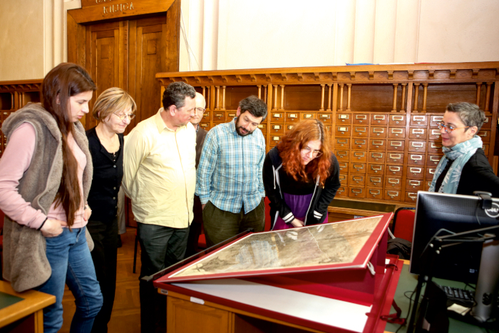
The importance of protection, i.e., conservation and restoration works, was pointed out by Andreja Dragojević PhD from the Croatian State Archives. As this the only copy in the world, the object itself has undergone various changes throughout its history. Non-destructive and micro-destructive research was carried out on the map. For the purpose of the research, it was necessary to research the material of the map in order to choose a work method and plan the conservation-restoration procedure. Familiarisation with the material included an analytical investigation of the composition of the material, its properties and characteristics, and the results obtained were compared with the results of analyses of samples from nearby time periods. The research results indicated that the method of minimal conservation-restoration procedures is the most suitable for the map, and additional storage and display equipment was created to minimize direct handling.
Through her work, Emilia Domazet introduced the professional and general community to the collection of maps and atlases that are part of the collection of the Metropolitan Library. The rich book collection contains old maps, atlases and panoramas that form a valuable part of the historical cartographic heritage, which, in addition to bearing the national characteristic and characteristics of each period, also have a very high aesthetic value with richly decorated cartouches and heraldic symbols. Attached to the work is a list of cartographic material from the 18th to the 20th century, which is kept in the Metropolitan Library.
Finally, we would like to point out that Stjepan Glavač and his map are not unknown. They were dealt with by many, from Kukuljević and Vanino to a whole series of scientists from the second half of the twentieth century until today, whose works were used in the papers printed in these Proceedings. We believe that the Proceedings will encourage new research on Glavač in foreign heritage institutions, for example in the University Library in Klagenfurt or the State Archives in Trnava. Once again, I would like to thank all the contributors to the Proceedings who contributed to the valorisation of Glavač's map, the first and unique geographical map of Croatia, because cartographic material is also part of cultural heritage, indispensable in the presentation of national and world history.
Hrvatski državni arhiv objavio je 2023. godine zbornik radova Glavačeva karta Hrvatske, ISBN 978-953-8461-06-4, 143 stranice. Urednica zbornika je Emilia Domazet, knjižničarka Metropolitanske knjižnice pri Hrvatskom državnom arhivu. Zbornik je nastao kao plod znanstvenog skupa i istoimene izložbe Glavačeva karta Hrvatske, održanog 16. rujna 2021. u organizaciji Metropolitanske knjižnice Zagrebačke nadbiskupije i Hrvatskoga državnog arhiva. S obzirom na to da je Stjepan Glavač bio isusovac i prvi profesor filozofije na Isusovačkoj akademiji u Zagrebu, predgovor je potpisao doc. dr. sc. Dalibor Renić, provincijal Hrvatske pokrajine Družbe Isusove. Zbornik je lektorirao Tomislav Salopek, a sažetak na engleski jezik preveo je Marijan Bosnar, arhivski savjetnik. Zbornik su recenzirali prof. dr. sc. Damir Hasenay s Filozofskog fakulteta Sveučilišta Josipa Jurja Strossmayera u Osijeku i dr. sc. Martina Triplat Horvat, dipl. ing. geod. Stručne UDK oznake dodijelila je knjižničarka Lucija Martina Vežić iz Nacionalne i sveučilišne knjižnice u Zagrebu. Zbornik je otisnut u mekom izdanju u 250 primjeraka, a objavljen je uz potporu Ministarstva kulture i medija Republike Hrvatske. Usluga prijelom i tiska zasluga je tiskare Kerschoffset.
U Zborniku je prikazano sedam radova koji s različitih gledišta progovaraju o najstarijoj karti Hrvatske, karti Stjepana Glavača iz 1673. godine. Tekstovi su potkrijepljeni ilustracijama i grafičkim prikazima. Svatko se iz svoje perspektive (geografije, geodezije, povijesti, povijesti umjetnosti, restauratorsko-konzervatorskog stajališta i knjižničarstva) osvrnuo na značaj Glavačeve karte za hrvatsku historiografiju i geografiju te upoznao čitatelje s manje poznatim detaljima koje ona krije.
Prof. dr. sc. Josip Faričić sa Sveučilišta u Zadru u svom se radu s geografskog stajališta bavi kartografskim prikazom prostora Hrvatske u 17. stoljeću. Autor je tekst zamislio kao prilog postojećim znanstvenim spoznajama sa svrhom kontekstualizacije i potvrde opravdanosti nakane Stjepana Glavača da ispravi pogreške i nedostatke na tadašnjim kartama Hrvatske. Rad se zasniva na istraživanju više desetaka karata koje su europski kartografi izradili tijekom 17. stoljeća. Među tim su kartama istaknute one koje su smatrane reprezentativnim uzorcima na temelju kojih je bilo moguće donijeti odgovarajuće zaključke o razvoju kartografiranja hrvatskog prostora i o uporabnoj vrijednosti tadašnjih kartografskih ostvarenja.
Doc. dr. sc. Marina Viličić s Geodetskog fakulteta Sveučilišta u Zagrebu piše o važnosti i utjecaju Glavačeve karte koji se očituju i u grafičkom mjerilu koje je izraženo u hrvatskim miljama. U istraživanju autorica je usporedila sadržaj (točnije naselja, tekućice i druge pojave voda, reljefa s pripadajućim toponimima) na Glavačevoj karti s istovrsnim sadržajem na kasnije objavljenim kartama. U radu je autorica koristila digitalne kopije pet karata: kartu Hrvatske Janeza Vajkarda Valvasora iz 1689., dvije karte Giacoma Cantellija iz 1690., kartu Antuna Belavića iz 1739. te kartu Kraljevine Dalmacije, Hrvatske i Slavonije iz 1746. nepoznatog autora. Budući da je nakon provedene usporedbe uočena velika sličnost Glavačeve karte s Belavićevom kartom i kartom Kraljevine Dalmacije…, za te dvije karte autorice je izračunala parametre afine i Helmertove transformacije koji upućuju na promjenu dimenzija i orijentaciju listova Glavačeve karte. Budući da su autori toliko vjerno prenosili sadržaj s Glavačeve karte u svoje djela, ovim je radom potvrđena teza da je Glavačeva karta bila nov i vrlo detaljan izvor podataka o hrvatskim krajevima u to doba.
Dr. sc. Milan Pelc iz Instituta za povijest umjetnosti ukazuje na likovnost i simbolička obilježja Glavačeve karte te zaključuje da nema razloga sumnjati da je sam Glavač pripremne crteže karte prenio na bakrene ploče, što i potvrđuje pri kraju tiskane posvete koja se nalazi na samoj karti. Prema autoru simbolika je zamišljena kao opozicija nečasnom šurovanju s neprijateljem i alegorijska potvrda spremnosti na sve potrebne napore u obrani vjere i domovine.
Povjesničar dr. sc. Mario Jareb iz Hrvatskog instituta za povijest, autor je rada koji se bavi heraldičkom ostavštinom Glavačeve karte, tj. grbovima Hrvatske, Dalmacije i Slavonije. On raščlambom grbova upućuje na njihovo simboličko povezivanje u smislu integracije hrvatskog državnog područja. Postavlja pitanje je li Glavač preuzeo način prikazivanja s drugih zemljopisnih karata ili mu je namjera bila prikazati kako su sve tri navedene sastavnice u tadašnjem nazivu hrvatske države bile bar pod vlašću hrvatskog kralja, odnosno Habsburgovaca, i hrvatskog bana.
Mr. sc. Ladislav Dobrica iz Hrvatskoga državnog arhiva opisuje povijesne događaje na karti Stjepana Glavača koji su uglavnom vezani za ratove s Osmanlijama od kraja 15. do polovice 17. stoljeća, ali i pojedine događaje vezane uz povijest ustanova Katoličke Crkve. Autor je u radu također dao prikaz izvora iz kojih je Glavač crpio podatke o povijesnim događajima te pritom analizirao specifičnosti pojedinih povijesnih događaja. Prilog radu jest i prijepis izvornih navoda povijesnih događaja te njihov prijevod na hrvatski jezik.
Na važnost zaštite, odnosno konzervatorsko-restauratorske radove ukazala je dr. sc. Andreja Dragojević iz Hrvatskog državnog arhiva. Kako je riječ o jedinstvenom primjerku u svijetu, sam objekt je kroz svoju povijest doživio razne promjene. Na karti su provedena nedestruktivna i mikrodestruktivna istraživanja. Radi potrebe istraživanja bilo je potrebno istražiti materijal karte kako bi se odabrala metoda rada i isplanirao konzervatorsko-restauratorski postupak. Upoznavanje s materijalom obuhvaćalo je analitičko istraživanje sastava materijala, njegovih svojstava i obilježja, a dobiveni rezultati uspoređivani su s rezultatima analiza uzoraka bliskih razdoblja. Rezultati istraživanja upućivali su na to da je metoda minimalnih konzervatorsko-restauratorskih postupaka najprimjerenija za kartu te je izrađena dodatna oprema za pohranu i izlaganje kako bi se izravno rukovanje svelo na minimum.
Emilia Domazet, svojim je radom stručnoj i široj zajednici približila zbirku karata i atlasa koja se nalazi u fondu Metropolitanske knjižnice. U bogatom knjižnom fondu nalaze se stare karte, atlasi i vedute koji čine vrijedan dio povijesne kartografske baštine, koje osim što nose nacionalno obilježje te obilježja svakog razdoblja, imaju i vrlo visoku estetsku vrijednost s bogato ukrašenim kartušama i heraldičkim simbolima. Prilog radu jest popis kartografske građe od 18. do 20. stoljeća koja se čuva u Metropolitanskoj knjižnici.
Na kraju želimo istaknuti da Stjepan Glavač i njegov zemljovid nisu nepoznati. Njime su se bavili mnogi, od Kukuljevića i Vanina do cijelog niza znanstvenika druge polovice dvadesetog stoljeća do danas, čiji su radovi korišteni u radovima tiskanim u ovome Zborniku. Vjerujemo kako će i ovaj Zbornik potaknuti nova istraživanja o Glavaču u stranim baštinskim ustanovama, primjerice u Sveučilišnoj knjižnici u Klagenfurtu ili Državom arhivu u Trnavi. Još jednom zahvaljujem svim suradnicima na Zborniku koji su doprinijeli valorizaciji Glavačeve karte, prve i jedinstvene zemljopisne karte Hrvatske, jer je kartografska građa također dio kulturne baštine, nezaobilazna u predstavljanju nacionalne i svjetske povijesti.