Skip to the main content

Review article

https://doi.org/10.32909/kg.19.33.1

Approaches and Solutions for Creating Atlases in Geographic Information Systems

Sergei Krylov orcid id orcid.org/0000-0002-5879-6502 ; Moscow State University of Geodesy and Cartography
Gleb Zagrebin ; Moscow State University of Geodesy and Cartography
Dmitriy Mosolov orcid id orcid.org/0000-0002-3125-018X ; Moscow State University of Geodesy and Cartography
Irina Shkurenkova orcid id orcid.org/0000-0003-2961-1836 ; Moscow State University of Geodesy and Cartography


Full text: croatian pdf 5.673 Kb

page 4-17

downloads: 247

cite

Full text: english pdf 5.673 Kb

page 4-17

downloads: 236

cite

Download JATS file


Abstract

The features, advantages and disadvantages of using QGIS, ArcGIS and MapInfo Pro when creating atlases of various types (geographic, complex and thematic) are considered in this paper. Schemes for their potential organization are presented and technological schemes for their automated creation in these geographic information systems are proposed. As a result, approaches and solutions for improving geographic information software can be formulated. Algorithms and modules were developed, primarily aimed at formalizing the structure of atlases and automating the design process of their mathematical basis. The development of functionality was implemented using built-in developer tools implemented in MapInfo as the MapBasic language, and in ArcGIS and QGIS in the Python programming language. A summary table was compiled, which presents the basic functionalities required to create atlases in GIS and their implementation in the appropriate software. These proposals will ensure the fulfillment of all requirements necessary for atlas design, primarily at the regional mapping level.

Keywords

atlas; atlases mapping; geoinformation system

Hrčak ID:

236047

URI

https://hrcak.srce.hr/236047

Publication date:

30.6.2020.

Article data in other languages: croatian

Visits: 1.451 *


Acknowledgments

This work was supported by the Ministry of Science and Higher Education of the Russian Federation, project 5.8029.2017/8.9.

The authors are grateful to the reviewers for their constructive and valuable comments.

Zahvale

Ovaj je rad podržalo Ministarstvo znanosti i visokog obrazovanja Ruske Federacije, projekt 5.8029.2017/8.9.

Autori su zahvalni recenzentima na njihovim konstruktivnim i vrijednim komentarima.

References


ArcGIS (2019) Building map books with ArcGIS. In:http://desktop.arcgis.com/en/arcmap/latest/map/page-layouts/building-map-books-with-arcgis.htm. Accessed 14 Oct 2019


Field K(2018) Cartography. Esri Press, Redlands


Fokin I, Krylov S, Zagrebin G (2016) The method of creating reliable cartographic images (illustrations) automatically. Proceedings of the Higher Educational Institutions. Izvestia vuzov «Geodesy and aerophotosurveying», no. 6, 78-84


Hurni L (2017) Atlas Information Systems. In: Shekhar S, Xiong H, Zhou X Encyclopedia of GIS. Springer, Cham. https://doi.org/doi:10.1007/978-3-319-17885-1_847


Khalugin E, Zhalkovskiy E, Zhdanov N (1992) Digital maps. Nedra, Moscow.


Makarenko A, Zagrebin G(2017) Principles under which the structure of atlases is organized. Proceedings of the Higher Educational Institutions. Izvestia vuzov «Geodesy and aerophotosurveying», no. 2, 63-66


Salishchev K (eds) (1976) Complex regional atlases. Publishing house of Moscow University, Moscow


Svatkova T (2002) Atlas cartography: a textbook. Aspect Press, Moscow


Vomsattel R, Sieber R, Hurni L (2019) Topic Selection and Structure in the National Atlas of Switzerland. Abstracts of The 29th International Cartographic Conference, no. 1, Tokyo, Japan, 15–20 July 2019, p 384. https://doi.org/doi:10.5194/ica-abs-1-384-2019.


Vozenilek V (2019) Atlases and Systems Theory within Systematic Cartography. In: Abstracts of The 29th International Cartographic Conference, no. 1, Tokyo, Japan, 15–20 July 2019, p 386. https://doi.org/doi:10.5194/ica-abs-1-386-2019


Zagrebin G, Krylov S (2019) The definition of scale series for atlas maps depending on the density of mapped objects. In: Abstracts of The 29th International Cartographic Conference, no. 1, Tokyo, Japan, 15–20 July 2019, p 423. https://doi.org/doi:10.5194/ica-abs-1-423-2019


This display is generated from NISO JATS XML with jats-html.xsl. The XSLT engine is libxslt.


Introduction

1

Geographic information systems (GIS) are widely used to create various cartographic works, despite the fact that they are inferior in design to publishing systems. When compiling atlases, GIS are currently used to perform individual cartographic processes, such as the development of spatial and thematic databases, creation of thematic maps, generalization of objects, creation of typical cartographic foundations and individual thematic maps, and the construction of various thematic surfaces, etc. Among studies on the use of GIS in the compilation of atlases and atlas information systems, the work of the Swiss cartographic school (Hurni 2017,Vomsattel et al. 2019) should be noted. Many common GIS also have a special functionality that allows a map to be cut (inserted) into the pages of an atlas, enabling the creation of multi-page cartographic works such as city and road atlases. Geographic, complex (integrated) and thematic atlases are characterized by complex structures and diverse relationships between their sections (Vozenilek 2019). Therefore, the use of GIS is limited in terms of creating these types of atlases as independent cartographic works with holistic structures and full content. Also, depending on the selected GIS, its technological and functional capabilities, there are different ways of creating atlases. Currently, the most common is the page-by-page approach, where the design of each atlas map is conducted in a separate working set, and the integration of the resulting maps and atlas is performed in the final stage, after the output of ready-made layouts from the software (Field 2018). This approach not provide automation of the process of compiling the atlas as a single, whole cartographic work.

Therefore, it is necessary to consider the features, advantages and disadvantages of using the most common GIS when creating atlases of various types (geographic, complex and thematic), propose schemes for the possible organization of such atlases, and develop technological schemes for their automated creation.

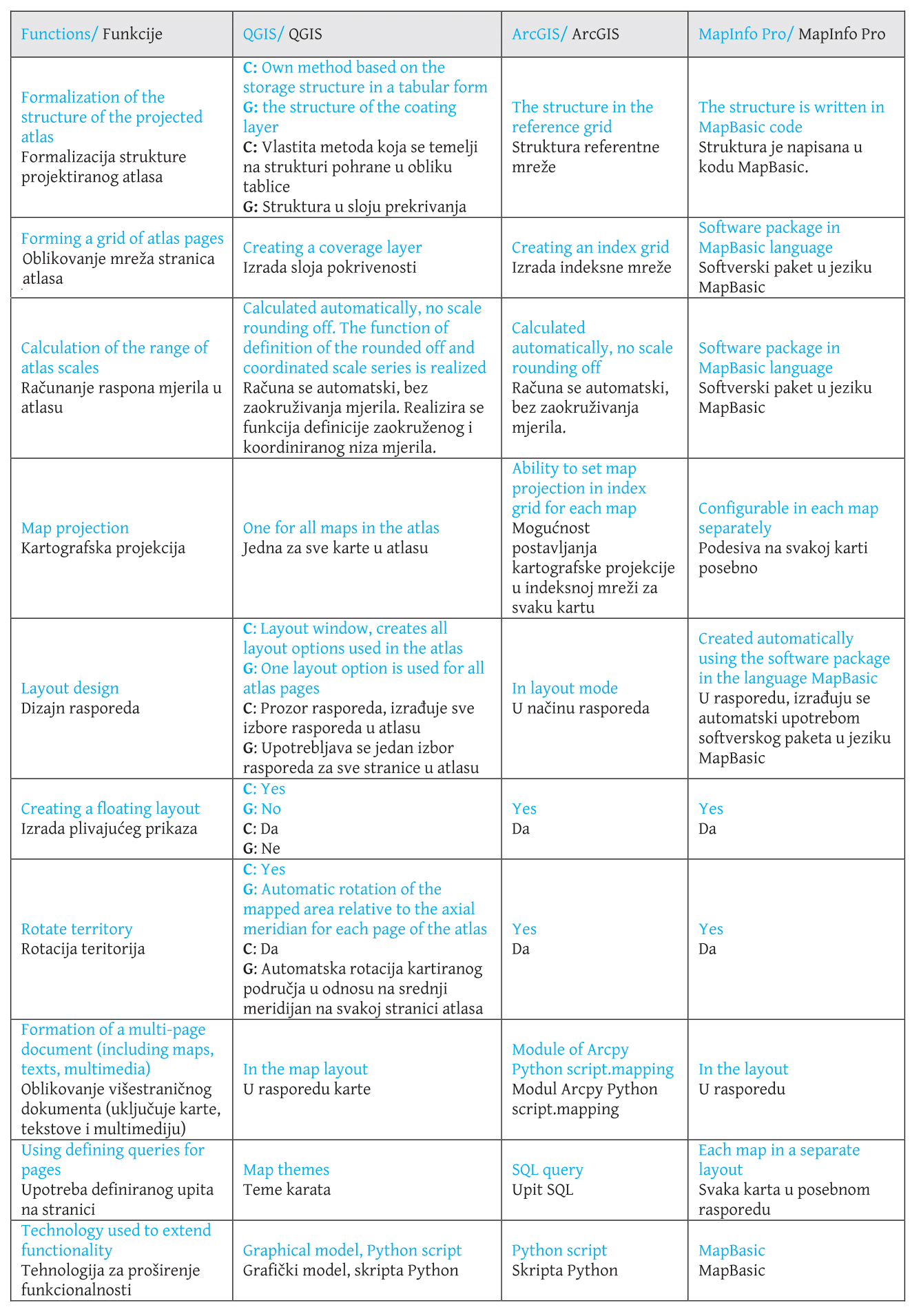
Principles of Atlas Structure Organization

2

For the study, we selected the QGIS, ArcGIS and MapInfo Pro full-featured geographic information systems, which have various tools for forming atlas structure and creating atlas maps. The overall approach to the formation of the atlas in GIS, depending on the purpose and content of the atlas, may vary. This is primarily due to the different atlas structures. We will consider each type of atlas in more detail.

General geographical atlases have the same type of content and their structure is well-established (Svatkova 2002). Hierarchical ordering allows the atlas to be divided into its component parts. For example, for the 1999 Atlas of the World, the following sections and subsections can be distinguished: 1. The world as a whole - an introductory section. 2. Russia, continents, oceans - overview maps. 2.1. Regional maps: 2.1.1. Level 1 subsections - regional overview maps. 2.1.2. Level 2 subsections - Detailed regional maps (Makarenko et al. 2017).

Thematic atlases consist mainly of maps of a single subject, showing the spatial distribution of certain processes or phenomena. The structure of thematic atlases is very individual (Svatkova 2002). The ordering of the mapping territory is organized according to the hierarchy of territorial coverage, and within each territory (section) there is a set of maps.

Complex (integrated) atlases provide systematic information on the full, comprehensive (polythematic) characteristics of the mapped territory. In these atlases, the constituent parts (sections) of a complex atlas traditionally form groups of physical maps and socio-economic maps, which in turn are divided into subsections or themes. “The number of maps in the atlas and their contents depend on the geographical features of the region, its knowledge, the availability of materials, and the possibility of their cartographic use” (Salishchev 1976). The main task in developing the structure of a complex atlas is to determine the necessary sections and the optimum list of maps in each section.

Creating Atlases in GIS: Analysis and Solutions

3

Fig. 1 Steps for creating atlases in GIS.
kig-19-4-g1.png
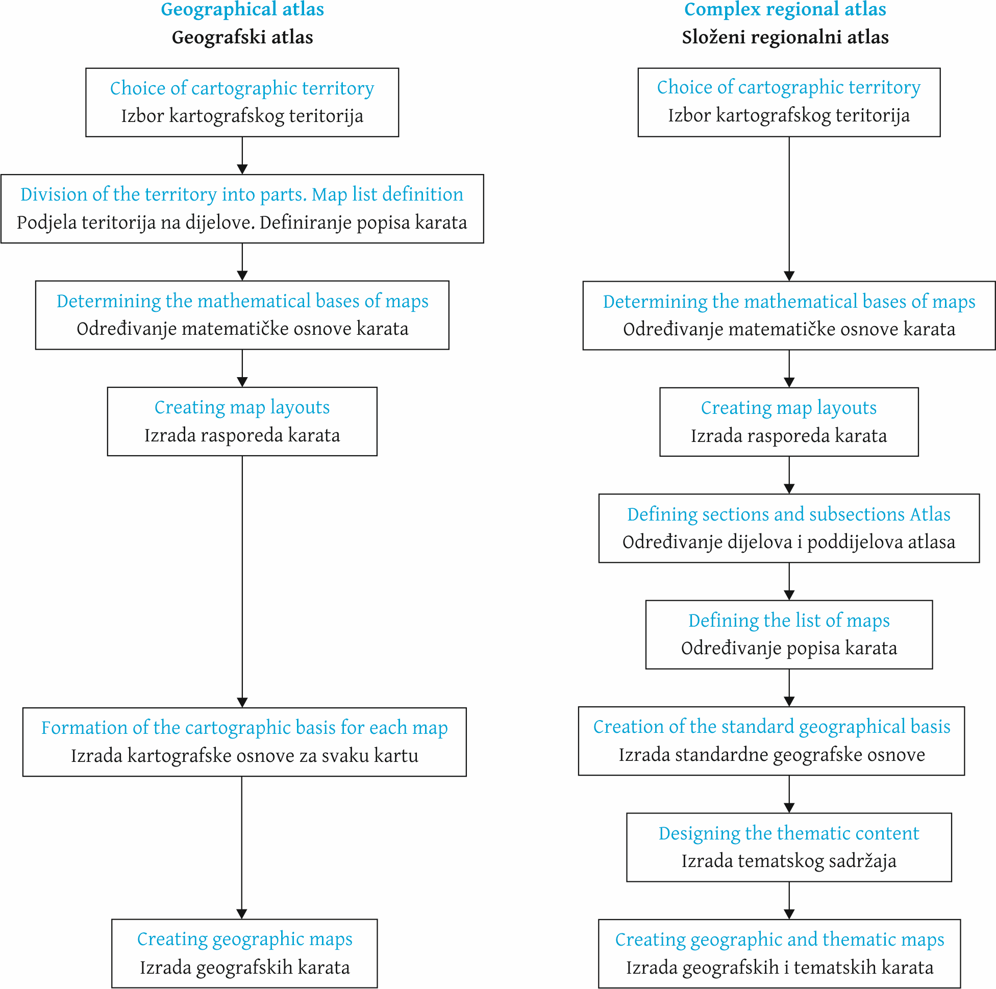
Figure 1 presents the main stages and features of the creation of geographic information systems and integrated regional atlases.

The main data source for creating an atlas of any type in GIS is a cartographic database - a set of organized arrays of digital cartographic information and software tools that provide access to data and their maintenance, storage and issuance (Khalugin et al. 1992). The initial composition of the cartographic database information (hydrography, settlements, traffic routes and borders) provides the typical bases of the atlas. The developed system of classification and coding of geographic objects and a single fixed format for recording digital cartographic information allow automization of the basic technological processes for creating atlases, for example, the cartographic generalization of objects.

It should be noted that when designing a geographic atlas, the cartographic database should be created at the most precise territorial level represented in the atlas. This is due to the presence of maps of the same content in geographic atlases, made for different levels of territorial coverage.

When creating thematic or complex regional atlases, besides the cartographic database, it is necessary to form the thematic database containing quantitative and qualitative indicators of the mapped object or phenomenon. To create socio-economic maps, the main source data are statistics.

When creating a thematic database for atlas mapping, it is necessary to develop tables that take into account all the indicators on all the created thematic maps. At the same time, depending on the cartographic imaging method used, and therefore the placement of the mapped phenomenon, it is possible to group the indicators in one table. So, for objects and phenomena placed in administrative units, it is advisable to create a single table containing indicators for different methods of cartographic image as well (for example, for cartograms and cartodiagrams). A separate table is created for objects localized in settlements. Communication of statistical information with metric information of layers in the cartographic database is carried out via the unique codes of administrative units and settlements (for example, for the Russian Federation, the OCTMO code is used).

For our study, we considered the features of creating geographical, thematic and integrated atlases in the QGIS, ArcGIS and MapInfo Pro geographic information systems. This choice of software was due to their wide functionality and prevalence in the Russian and foreign geographic information services markets.

QGIS

QGIS is a free, full-featured, open-source geographic information system. It is used to create, edit, visualize, analyze and publish geospatial information.

The formation and configuration of the atlas in QGIS based on the layers opened in the project takes place in the process of creating a layout, which is a separate window with tools for the creation, design and layout of cartographic works. To do this, the layout window provides a separate tab Atlas (Atlas-Atlas Settings) with a set of the following functions

  1. enable atlas generation option

  2. select a layer and objects in it, on the basis of which the map will be divided into sheets (Coverage layer, Filter with)

  3. define a table field or specify an expression by which the atlas pages will be sorted

  4. specify a file name when exporting the atlas to external data formats

.

Navigating through the pages of the atlas is done using the menu command Atlas - Preview Atlas, and this function must be activated every time you change the content of the layout. The menu also contains tools to print the atlas, export the atlas pages as a bitmap, and save the atlas pages in SVG and PDF format.

The display settings for the selected elements of the layout pages (maps, legends, etc.) are set using the functions of the standard tab Item Properties. For maps, you can set the coordinate system, the rotation angle of the map, or create a map grid, etc. At the same time, it is possible to establish a single coordinate system and, accordingly, a single cartographic projection for atlas maps, which means QGIS cannot create some geographical and thematic atlases which use several different projections for different territories (for example, world atlases).

For geographical atlases of the Russian Federation, it is possible to use a single cartographic projection on the entire mapping territory. So it is possible to use a class of conical projections, while the change of the axial meridian for each subject is not carried out in the parameters of the coordinate system, but by simply rotating the map at an angle calculated as the difference between the axial meridian of the entire territory and the longitude of the centroid of the subject. This requires additional calculations.

Item Properties also specifically enables atlas creation under the option Controlled by atlas, which allows the user to select one of the following options to define the scale for the pages of the atlas: generating a scale taking into account the space used in division of atlas objects (Margin around feature); automatic calculation of scale range (Predefined scale (best fit)); and setting a fixed single scale (Fixed scale). Experiments have shown that it is impossible to use this QGIS functionality when creating geographic and complex atlases. So, in the first case, the scale for each page of the atlas is unique and not rounded off, and this does not automatically generate the correct scale series of the atlas. In the second variant, there is a strong degree of rounding off. The use of a fixed scale does not meet the design requirements of an atlas as a map system.

Thus, we can draw the following conclusion. QGIS has advanced functionality to customize the layouts of cartographic works, allowing the quick creation of maps on each page of the atlas. Thus for geographical atlases, the identical contents for different mapped territories are formed, while for complex regional atlases, the different thematic contents for the same territory are formed. QGIS also allows the creation of a single style of atlas page.

However, the creation of geographic, thematic, and complex atlases in QGIS is limited by the following software flaws:

  • inability to calculate and correctly round off the scale of maps for different sizes of territories

  • the absence of a choice of a coordinate system for each individual map

  • the need to calculate the rotation angle for each map of the atlas

  • the time-consuming process of creating floating layout maps

.

Therefore, the authors propose solutions to improve the process of creating general geographic and complex regional atlases in QGIS (Figure 2).

Fig. 2 Solutions developed to improve the process of creating geographic and complex atlases in QGIS.
kig-19-4-g2.png
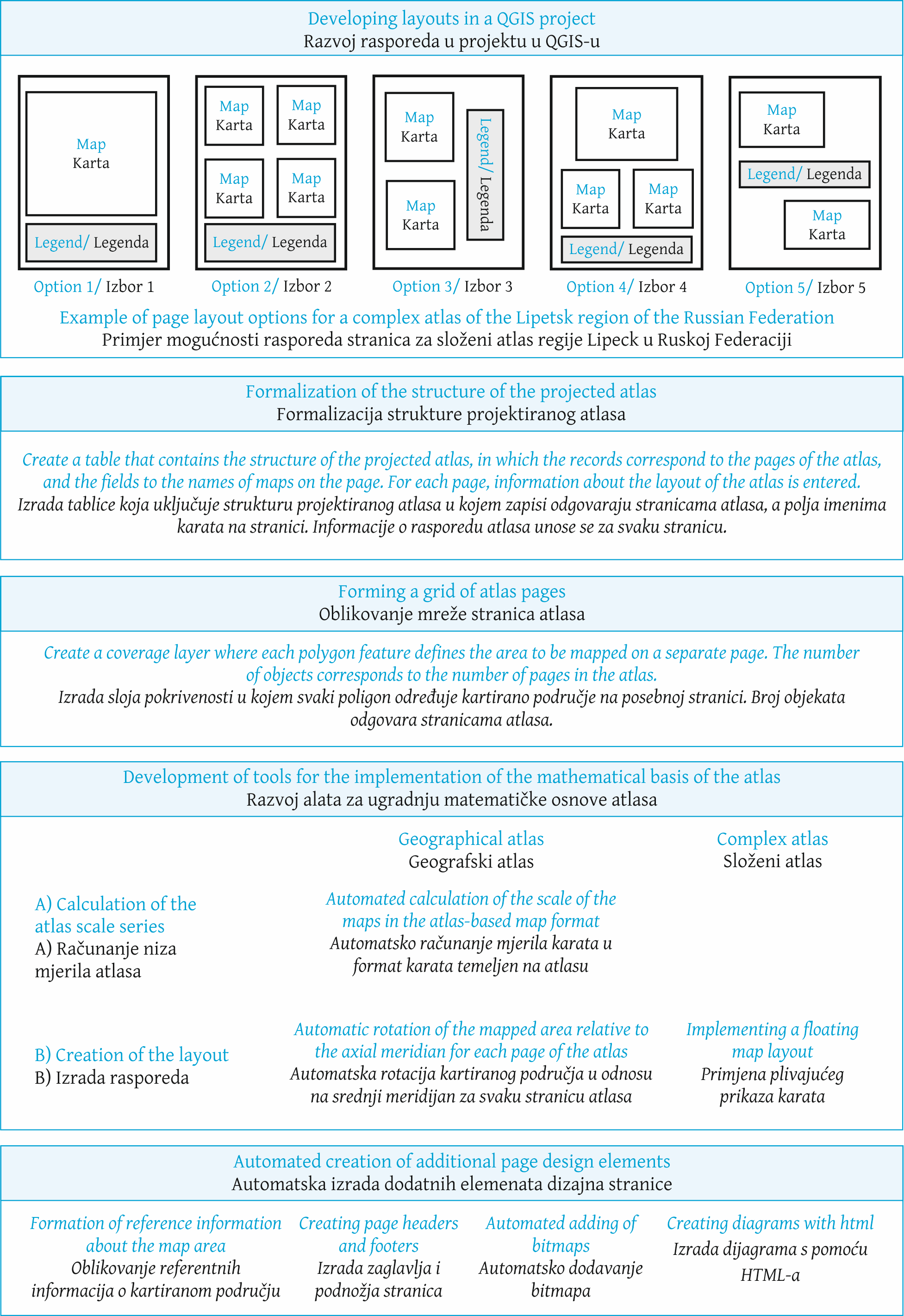
Primarily, these solutions are aimed at formalizing the structure of the projected atlas and automating the design process of its mathematical basis, including the definition of a large-scale series of atlas maps (Zagrebin et al. 2019). A separate block of developments is devoted to the automated creation of additional elements of the atlas page design - map headers, footers and additional text information about the mapped territory. It should be noted that the proposed list of solutions is not final and may be supplemented as modules and algorithms are developed.

ArcGIS

ESRI's ArcGIS geographic information system is used to build GIS at any level. ArcGIS enables geographic information to be used, analyzed and understood, leading to better decision-making and the creation and publication of maps as print versions, desktop applications, portals, and maps for mobile devices.

In general, QGIS and ArcGIS are similar in functionality and ideology of modules, but ArcGIS has a more developed toolkit for creating atlases and multi-page maps. The following features of ArcGIS (ArcGIS 2019) can be noted, automating the process of creating geographic and complex atlases:

  • using the Python Arcpy script module.mapping. This module extends the functionality of multi-page layout and is necessary to create atlas pages that do not contain maps. When a multipage layout is created on a coverage layer (index grid), a separate page is created for each grid cell that corresponds to a separate map, but pages without maps will not be created. At the same time, the development of atlas mapping and the principles of creating atlases is moving towards the supply of cartographic material with additional information, such as cartographic illustrations (Fokin et al. 2016), graphs and diagrams, explanatory text and multimedia files

  • setting the coordinate system for each window or frame in the map. This allows t a separate coordinate system to be set for each window of the map, which is prescribed in a separate field of the index table. The coordinate system is defined as a text string with three possible entries: a description in WKT format, a link to an external WKT file, or an EPSG code. This feature allows atlases to be created with several classes of map projections

  • using defining queries for pages in the atlas. A defining query allows the SQL query to be used to limit the display of objects in a separate map window, which allows the content of each individual map of the Atlas being created to be controlled

.

MapInfo Pro

GIS MapInfo Pro (developed by Pitney Bowes Software Inc.) is a powerful tool for working with spatial data and creating maps. The program allows the most complex problems of geographical analysis to be solved, such as zoning, communication with remote databases, the inclusion of graphical objects in other applications, the creation of thematic maps, identifying trends and patterns in the distribution of data and much more. Data in MapInfo Pro can be presented in the form of maps, lists, legends, graphs and reports.

The main advantage of MapInfo Pro for use in atlas mapping is the ability to create multiple maps and reports within a single working set (project). This allows the creation of a multi-page document using maps with different source data, mathematical basis and content, which makes MapInfo Pro suitable for creating general geographic, complex regional and thematic atlases. However, in this case, a large number of maps and reports are created in one working set, which makes it difficult to navigate internally in the atlas. This organization of the atlas structure is shown in Figure 3.

Fig. 3 Organization of the atlas structure in MapInfo Pro.
kig-19-4-g3.png
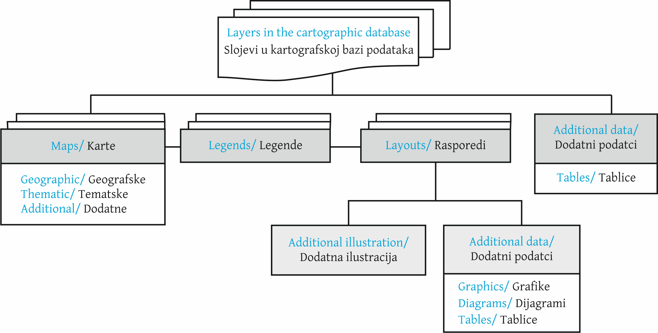
At the same time, thematic maps are created for complex atlases.

Another approach can be used to create a comprehensive atlas in MapInfo Pro GIS, as shown in Figure 4.

Fig. 4 Organization of the complex regional atlas structure in MapInfo Pro with the creation of typical bases.
kig-19-4-g4.png
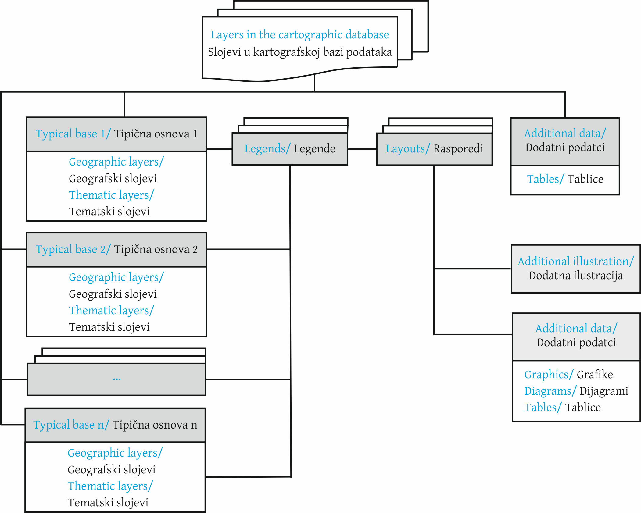
In this case, the structure of the atlas is presented by the typical geographical bases used in the atlas, containing the main elements: boundaries, hydrography, settlements and traffic routes. Next, the layers that make up the thematic content of the maps are superimposed on the typical bases. The number of typical bases depends on the scale and content of the maps (physical maps and socio-economic maps). For example, 
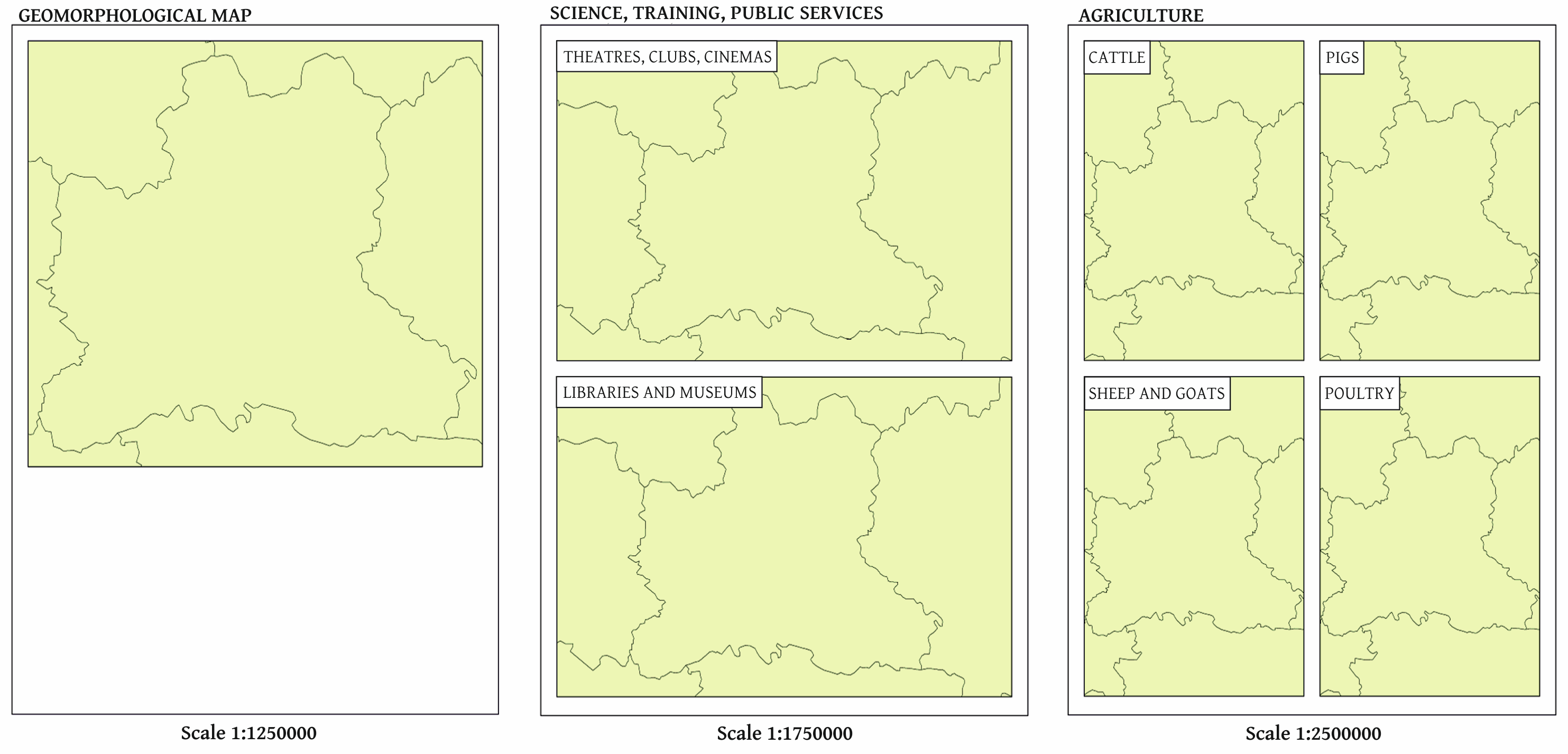
when creating a comprehensive atlas of the Lipetsk region of the Russian Federation, the following typical bases are formed: "Physical maps 1:1 250 000"; "Physical maps 1:1 750 000", "Socio-economic maps 1:1 250 000", "Socio-economic maps 1:1 750 000". The creation of separate typical bases for physical maps and socio-economic maps is due to the different composition of the geographical information displayed.

The proposed approach will reduce the number of maps in the program. However, it will be necessary to turn on and off the thematic layers manually to display and print different maps made on the same typical basis. Thus, it will not be possible to view multiple thematic maps created on the same basis at the same time.

Implementation of the proposed organization of a complex regional atlas in GIS MapInfo Pro is only made possible by writing additional modules in the MapBasic programming language. To date, the authors have developed a software complex meant for automated creation of the structure of the atlas and submitting the obtained structure in the form of an additional menu, which corresponds to the projected table of contents of the atlas. Clicking on each menu item opens a report containing the corresponding map or maps, depending on the layout selected (Figure 5).

Fig. 5 Example of creating atlas reports in different layouts using a software package.
kig-19-4-g5.png

Results

4

Based on the results of the analysis of geographic information systems, a summary table (Table 1)

Table 1 Main functionality of GIS and proposed solutions to automate atlas creation.
kig-19-4-g6.png
was compiled which presents the main functionality required to create atlases in GIS and their implementation in the considered software. If the function for each atlas is different, it is indicated by abbreviations: C - complex atlas, G – geographical atlas. In the absence of standard functionality in a particular GIS, the cell of the corresponding function is prescribed as it can be solved with the help of other standard tools or indicated by the authors of the software module. Thus, the table gives the solutions and tools to be used to solve the problems of atlas design in GIS at each stage.

Conclusion

5

Despite the fairly well developed means of creating atlases in all the geographic information systems considered, their functionality is not sufficient for the full creation of geographical, thematic and complex regional atlases. In the article, the authors considered the features, advantages and disadvantages of using QGIS, ArcGIS and MapInfo Pro when creating atlases of various types, developed the basic principles of designing the structure of the atlases in each geographic information system, and carried out practical implementation.

As a result, two approaches to the creation of atlases in these geographic information systems were identified:

  • MapInfo Pro implements a flexible map reporting system that allows each report to be customized individually, but to combine them into a single Atlas structure, additional functionality must be written into the MapBasic language;

  • in ArcGIS and QGIS, creating multipage documents involves a rigid coverage layer (index grid) structure, which leads to a more systematic approach when designing an atlas structure. But the rigid structure of the coverage layer leads to less flexible design of separate atlas pages, and the imperfections of the toolkit (especially in QGIS) require the writing of additional modules in the Python programming language

.

The approaches and solutions formulated for improving the considered GIS allow the basic processes for creating atlases to be automated. These proposals are of particular practical importance in the creation of integrated regional atlases showing the situation in the region in many areas of knowledge and used in decision-making at the regional and municipal levels to ensure the sustainable development of territories. This is due to the availability of a large set of available spatial and statistical data (including population censuses and data from statistical services), allowing for the creation of a variety of thematic maps.

For the creation of fundamental cartographic works, such as national atlases or atlases of the world and parts of the world, a very detailed and comprehensive study involving a large number of specialists is needed, which would entail considerable financial, human and time resources.


Uvod

1.

Geografski informacijski sustavi (GIS) primjenjuju se u izradi različitih kartografskih proizvoda premda je njihov dizajn inferioran onome izdavačkih sustava. Pri izradi atlasa GIS-ovi se trenutno primjenjuju za razvoj prostornih i tematskih baza podataka, izradu tematskih karata, generalizaciju objekata, izradu tipičnih kartografskih osnova i pojedinačnih tematskih karata, izradu različitih tematskih ploha, itd. Za neka istraživanja upotrebe GIS-a pri izradi atlasa i atlasnih informacijskih sustava zaslužna je švicarska kartografska škola (Hurni 2017,Vomsattel i dr. 2019). Osim toga, mnogi česti GIS-ovi sadrže posebnu funkcionalnost koja omogućava korisniku rezanje (umetanje) karte među stranice atlasa, što omogućuje izradu višestraničnih kartografskih proizvoda kao što su atlasi gradova, atlasi cesta itd. Geografski, složeni (integrirani) i tematski atlasi odlikuju se složenim strukturama i različitim odnosima među njihovim dijelovima (Vozenilek 2019). Prema tome, GIS-ovi su ograničeni u izradi tih tipova atlasa kao samostalnih kartografskih proizvoda holističke strukture i cjelovitog sadržaja. Osim toga, ovisno o izabranom GIS-u te njegovim tehnološkim i funkcionalnim mogućnostima, atlase je moguće izraditi na različite načine. Trenutačno je najčešći pristup stranicu-po-stranicu, u kojem se svaka karta atlasa izrađuje u posebnom radnom skupu, a te se karte integriraju u posljednjoj fazi, nakon izlaza gotovih rasporeda iz softvera (Field 2018). Takav pristup ne automatizira izradu atlasa kao jedinstveni kartografski proizvod.

Nužno je, stoga, razmotriti obilježja, prednosti i nedostatke najčešćih GIS-ova za izradu različitih tipova atlasa (geografskih, složenih i tematskih), predložiti sheme moguće organizacije takvih atlasa i razviti tehnološke sheme za njihovu automatsku izradu.

Načela organizacije strukture atlasa

2.

U istraživanju smo izabrali potpuno opremljene geografske informacijske sustave QGIS, ArcGIS i MapInfo Pro koji imaju različite alate za oblikovanje strukture atlasa i izradu atlasnih karata. Povrh toga, ovisno o svrsi i sadržaju atlasa, postoje različiti pristupi izradi atlasa u GIS-u. To je prvenstveno tako zbog različitih struktura atlasa. Razmotrimo svaki tip atlasa detaljnije.

Opći geografski atlasi istog su tipa sadržaja, njihova je struktura prilično utvrđena (Svatkova 2002) i može se pripisati hijerarhijskom redoslijedu koji podrazumijeva mogućnost podjele atlasa na njegove sastavne dijelove. Na primjer, u Atlasu svijeta 1999 (Atlas of World 1999) možemo razlikovati sljedeće dijelove i poddijelove: 1. Cijeli svijet – uvodni dio. 2. Rusija, kontinenti, oceani – pregledne karte. 2.1. Regionalne karte: 2.1.1. Poddijelovi prvoga reda – regionalne pregledne karte. 2.1.2. Poddijelovi drugoga reda – detaljne regionalne karte (Makarenko i dr. 2017).

Tematski se atlasi prvenstveno sastoje od karata koje prikazuju jedan subjekt, a prikazuju i prostornu raspodjelu određenih procesa ili pojava. Struktura tematskih atlasa može biti vrlo različita (Svatkova 2002). Redoslijed kartiranog teritorija organiziran je prema načelu hijerarhije i teritorijalne pokrivenosti, a unutar svakog teritorija (dijela) nalazi se skup karata.

Složeni (integrirani) atlasi sadrže sustavne informacije o sveobuhvatnim (politematskim) svojstvima kartiranog teritorija. Sastavni se dijelovi takvog atlasa tradicionalno grupiraju u karte prirode i socioekonomske karte koje se dalje dijele na poddijelove / teme. Nadalje, “broj karata u atlasu i njihov sadržaj ovisi o geografskih obilježjima regija, o njihovu poznavanju, dostupnosti materijala i mogućnostima njihove kartografske upotrebe” (Salishchev 1976). Glavni je zadatak u razvoju strukture složenog atlasa odrediti potrebne dijelove i optimalan popis karata u svakom dijelu.

Izrada atlasa u GIS-u. Analiza i rješenja

3.

Slika 1. Koraci izrade atlasa s pomoću GIS-a.
kig-19-4-g1.png
Slika 1 prikazuje glavne faze i obilježja izrade geografskih informacijskih sustava i integriranih regionalnih atlasa.

Glavni je izvor podataka za izradu bilo kakvog atlasa u GIS-u kartografska baza podataka – skup organiziranih digitalnih kartografskih informacija i softverskih alata koji omogućuju pristup podatcima, njihovo održavanje, pohranu i izdavanje (Khalugin i dr. 1992). Početni sastav informacija kartografske baze podataka (hidrografija, naselja, prometni putovi i granice) omogućuje izradu tipičnih osnova atlasa. Razvijen sustav klasifikacije i kodiranja geografskih objekata, jedinstveni fiksni format za bilježenje digitalnih kartografskih informacija omogućuje automatizaciju osnovnih tehnoloških procesa izrade atlasa, na primjer kartografske generalizacije objekata itd.

Treba napomenuti da je pri izradi geografskog atlasa kartografsku bazu podataka potrebno izraditi na najpreciznijoj teritorijalnoj razini prikazanoj u tom atlasu i to zbog karata istog sadržaja u geografskim atlasima izrađenima za različite razine teritorijalne pokrivenosti.

U slučaju izrade tematskih ili kompleksnih regionalnih atlasa, osim kartografske baze podataka, potrebno je izraditi tematsku bazu podataka koja sadrži kvantitativne i kvalitativne pokazatelje kartiranog objekta ili pojave. Glavni su izvor podataka za izradu socioekonomskih karata statistički podatci.

Pri izradi tematske baze podataka za kartiranje atlasa potrebno je izraditi tablice koje uzimaju u obzir sve pokazatelje na svim izrađenim tematskim kartama. Istodobno, ovisno o upotrijebljenim metodama kartografskog prikaza, a prema tome ovisno o metodi smještaja kartirane pojave, moguće je grupirati pokazatelje u jednu tablicu. Stoga se za objekte i pojave u administrativnim jedinicama preporučuje izraditi jednu tablicu koja sadrži pokazatelje čak i za različite metode kartografskih prikaza (na primjer, kartogram i kartodijagram). Posebna se tablica izrađuje za objekte u naseljima. Komunikacija statističkih informacija s metrijskim informacijama slojeva u kartografskoj bazi podataka vrši se uz pomoć jedinstvenih kodova administrativnih jedinica i naselja (na primjer za Rusku Federaciju upotrebljava se kod OCTMO).

U našem istraživanju razmatramo obilježja izrade geografskih, tematskih i integriranih atlasa s pomoću geografskih informacijskih sustava QGIS, ArcGIS i MapInfo Pro. Taj se izbor softvera temelji na njihovoj širokoj funkcionalnosti i upotrebi na ruskom i inozemnom tržištu geografskih informacijskih usluga.

QGIS

QGIS je besplatan, cjelovit geografski informacijski sustav otvorenoga koda. Namijenjen je za izradu, uređivanje, vizualizaciju, analizu i objavljivanje geoprostornih informacija.

Izrada i konfiguracija atlasa u QGIS-u temelji se na slojevima otvorenima u projektu i provodi se u procesu izrade rasporeda, što je poseban prozor s alatima za izradu kartografskih proizvoda. Kako bi to bilo moguće, prozor pruža dodatnu karticu Atlas (Atlas-Atlas Settings) sa sljedećim funkcijama:

  • omogućavanje izrade atlasa

  • izbor sloja i objekata u njemu, na temelju čega će karta biti podijeljena na listove (Coverage layer, Filter with)

  • definiranje polja tablice ili izraza prema kojem će stranice atlasa biti sortirane

  • određivanje imena datoteke pri izvozu atlasa u vanjske formate podataka

.

Za omogućivanje prijelaza između stranice atlasa služi naredba Atlas - Preview Atlas i tu je funkciju potrebno aktivirati svaki put kad promijenimo sadržaj rasporeda. U izborniku Atlas nalaze se i alati za ispis atlasa, izvoz stranica atlasa kao bitmapa, pohrana stranica atlasa u formatima SVG i PDF.

Postavke prikaza izabranih elemenata stranica rasporeda (karte, legende itd.) postavljaju se funkcijama kartice Item Properties. Za karte je moguće odrediti koordinatni sustav, kut rotacije karte, izradu mreže karte itd. Istodobno je otkriveno da je moguće zadati samo jedan koordinatni sustav i, shodno tome, jednu kartografsku projekciju atlasnih karata, što znači da uz pomoć QGIS-a nije moguće izraditi geografske i tematske atlase koji sadrže nekoliko različitih projekcija za različite teritorije (na primjer atlase svijeta).

Geografski atlas Ruske Federacije moguće je izraditi upotrebom jedne kartografske projekcije za cijeli teritorij kartiranja. Stoga je moguće upotrijebiti konusne projekcije, dok se promjena srednjeg meridijana za svaki subjekt ne radi s pomoću parametara koordinatnog sustava, već jednostavnom rotacijom karte za stupanj izračunan kao razlika između srednjeg meridijana cijelog teritorija i geografske dužine centroida subjekta. To zahtijeva dodatna računanja.

U kartici Item Properties također se nalazi mogućnost za izradu atlasa Controlled by atlas koja omogućuje korisniku izbor jedne od sljedećih mogućnosti definiranja mjerila stranica atlasa: izradu mjerila koja uzima u obzir prostor upotrijebljen pri dijeljenju objekata atlasa (Margin around feature), automatsko računanje raspona mjerila (Predefined scale (best fit)) te postavljanje fiksnog mjerila (Fixed scale). Eksperimenti su pokazali da tu funkcionalnost QGIS-a nije moguće primijeniti za izradu geografskih i kompleksnih atlasa. U prvom se slučaju mjerilo svake stranice atlasa računa jedinstveno i ne zaokružuje se, što ne stvara automatski točan niz mjerila u atlasu. Nasuprot tome, u drugom je slučaju prisutan velik stupanj zaokruživanja. Upotreba fiksnog mjerila ne udovoljava zahtjevima atlasa kao sustava karata.

Prema tome, možemo izvesti sljedeći zaključak - QGIS ima napredne funkcionalnosti u pogledu prilagođavanja rasporeda kartografskih proizvoda, što omogućuje brzu izradu karata na svakoj stranici atlasa. Stoga se za različite kartirane teritorije u geografskim atlasima izrađuje identičan sadržaj, a različiti tematski sadržaji istog teritorija u složenim regionalnim atlasima. QGIS također omogućuje izradu jednog stila stranica atlasa.

Međutim, izrada geografskih, tematskih i složenih atlasa u QGIS-u ograničena je sljedećim nedostacima softvera:

  • nemogućnost računanja i točnog zaokruživanja mjerila karata za teritorije različitih veličina

  • odsutnost izbora koordinatnog sustava za svaku pojedinu kartu

  • potreba računanja kuta rotacije za svaku stranicu atlasa

  • vremenski zahtjevna izrada plivajućeg prikaza karte

.

Autori, stoga, predlažu rješenja za poboljšanje procesa izrade općih geografskih i složenih regionalnih atlasa u QGIS-u (slika 2).

Slika 2. Razvijena rješenja poboljšanja procesa izrade geografskih i složenih atlasa s pomoću QGIS-a.
kig-19-4-g2.png
Ta su rješenja usmjerena na formaliziranje strukture projektiranog atlasa i automatizaciju određivanja matematičke osnove atlasa, uključujući definiciju niza karata krupnog mjerila u atlasu (Zagrebin i dr. 2019). Drugi je razvojni blok posvećen automatskoj izradi dodatnih elemenata dizajna stranice atlasa – zaglavlja, podnožja i dodatnih tekstualnih informacija o kartiranom teritoriju. Treba napomenuti da predloženi popis rješenja nije konačan te da ga je, kako se budu razvijali moduli i algoritmi, moguće i dopunjavati.

ArcGIS

Općenito govoreći, QGIS i ArcGIS slični su po funkcionalnosti i ideologiji modula, no ArcGIS ima razvijenije alate za izradu atlasa i karata koje se sastoje od više stranica. Navodimo i obilježja ArcGIS-a (ArcGIS 2019) koja automatiziraju proces izrade geografskih i složenih atlasa:

  • Python Arcpy script module.mapping je modul koji proširuje funkcionalnost višestraničnog rasporeda i nužan je za izradu stranica atlasa koje ne sadrže karte. Kad stvorite višestranični raspored u sloju pokrivenosti (indeksna mreža), izrađuje se posebna stranica za svaku ćeliju mreže koja odgovara posebnoj karti, ali stranice bez karata neće biti izrađene. Istodobno, razvoj kartiranja atlasa i principa izrade atlasa kreće se prema opskrbi kartografskog materijala dodatnim informacijama, poput kartografskih ilustracija (Fokin i dr. 2016), grafova i dijagrama, tekstova s objašnjenjima i multimedijskih datoteka.

  • Postavljanje koordinatnog sustava za svaki prozor / okvir na karti omogućuje korisniku određivanje posebnog koordinatnog sustava za svaki prozor na karti, što je propisano u posebnom polju u indeksnoj tablici atlasa. Koordinatni je sustav definiran kao tekst s trima mogućim unosima: opis u formatu WKT, poveznica s vanjskom datotekom WKT ili kod EPSG. Time se omogućuje izrada atlasa s nekoliko razreda kartografskih projekcija.

  • Upotreba definiranih upita za stranice atlasa omogućuje upotrebu upita SQL za ograničavanje prikaza objekata u posebnom prozoru karte, što onda omogućuje upravljanje sadržajem svake pojedina karte atlasa koji se izrađuje

.

MapInfo Pro

GIS MapInfo Pro (koji razvija Pitney Bowes Software Inc) moćan je alat za rad s prostornim podatcima i izradu karata. Program omogućuje rješavanje najsloženijih zadataka geografske analize, kao što su zoniranje, komunikacija s udaljenim bazama podataka, uključivanje grafičkih objekata u drugim programima, izrada tematskih karata, identifikacija trendova i uzoraka u raspodjeli podataka i još mnogo toga. Podatci u programu MapInfo Pro mogu se prikazati u obliku karata, popisa, legendi, grafova i izvještaja.

Glavna je prednost programa MapInfo Pro za izradu atlasa mogućnost izrade više karata i izvještaja unutar jednog radnog skupa (projekta). To omogućuje izradu višestraničnog dokumenta različitih izvornih podataka, matematičke osnove i sadržaja, što čini MapInfo Pro prikladnim za izradu općih geografskih, složenih regionalnih i tematskih atlasa. Međutim, u tom se slučaju izrađuje velik broj karata i izvještaja, što otežava snalaženje unutar atlasa. Ta je organizacija strukture atlasa prikazana na slici 3.

Slika 3. Organizacija strukture atlasa u programu MapInfo Pro.
kig-19-4-g3.png
Pri tome se tematske karte izrađuju za složene atlase.

Kao što je prikazano na slici 4

Slika 4. Organizacija strukture složenog regionalnog atlasa i izrada tipične osnove u programu MapInfo Pro.
kig-19-4-g4.png
, moguće je primijeniti drugi pristup za izradu sveobuhvatnog atlasa u programu MapInfo Pro. U tom je slučaju struktura atlasa prikazana tipičnim geografskim osnovama upotrijebljenima u atlasu i sadrži glavne elemente: granice, hidrografiju, naselja i prometne putove. Sljedeći je korak prekrivanje tipičnih osnova slojevima koji čine tematski sadržaj karata. Broj tipičnih osnova ovisi o mjerilu i sadržaju karata (karte prirode i socioekonomske karte). Na primjer, sljedeće se osnove oblikuju za izradu sveobuhvatnog atlasa regije Lipeck u Ruskoj Federaciji: „fizičke karte 1:1 250 000“; „fizičke karte 1:1 750 000“, „društveno-gospodarske karte 1:1 250 000“, „društveno-gospodarske karte 1:1 750 000“. Posebne tipične osnove za karte prirode i društveno-gospodarske karte izrađuju se zbog različitog sastava prikazanih geografskih informacija.

Predloženi će pristup smanjiti broj karata u programu. Međutim, bit će nužno ručno uključiti i isključiti tematske slojeve za prikazivanje i ispit različitih karata izrađenih na istoj tipičnoj osnovi. Prema tome, neće biti moguće istodobno pregledavati više tematskih karata izrađenih na istoj osnovi.

Ugrađivanje predložene organizacije složenog regionalnog atlasa u programu MapInfo Pro moguće je samo izradom dodatnih modula u programskom jeziku MapBasic. Do sada su autori razvili softverski kompleks za automatsku izradu strukture atlasa i slanje dobivene strukture u obliku dodatnog izbornika, što odgovara sadržaju atlasa. Odabirom stavke u izborniku otvara se izvještaj koji sadrži odgovarajuću kartu ili karte, ovisno o izabranom rasporedu (slika 5).

Slika 5. Primjer izrade atlasnih izvještaja različitih rasporeda s pomoću softverskog paketa.
kig-19-4-g5.png

Rezultati

4.

Na temelju rezultata analize geografskih informacijskih sustava izrađena je pregledna tablica (tablica 1)

Tablica 1. Glavna funkcionalnost GIS-ova i predložena rješenja za automatsku izradu atlasa.
kig-19-4-g6.png
koja prikazuje glavnu funkcionalnost potrebnu za izradu atlasa s pomoću GIS-a i njihovu ugradnju u razmotrenim softverima. Ako je funkcija za svaki atlas različita, to je označeno skraćenicama: C – složeni atlas, G – geografski atlas. U slučaju odsutnosti standardne funkcionalnosti pojedinog GIS-a u polju odgovarajuće funkcije opisano je kako se to može riješiti s pomoću drugog standardnog alata ili upućivanjem na autore softvera. Prema podatcima u tablici moguće je shvatiti koja rješenja i alate treba primijeniti u svakoj fazi rješavanja zadataka izrade atlasa s pomoću GIS-a.

Zaključak

5.

Unatoč prilično razvijenom načinu izrade atlasa u svim geografskim informacijskim sustavima koje smo razmotrili, njihova funkcionalnost nije dostatna za potpunu izradu geografskih, tematskih i složenih regionalnih atlasa. Autori su u članku razmotrili obilježja, prednosti i nedostatke upotrebe programa QGIS, ArcGIS i MapInfo Pro za izradu različitih tipova atlasa, razvili osnovna načela dizajna strukture atlasa u svakom geografskom informacijskom sustavu i primijenili ih u praksi.

Rezultat su dva pristupa izradi atlasa s pomoću razmotrenih geografskih informacijskih sustava:

  • MapInfo Pro sadrži fleksibilan sustav izvještavanja o kartama koji korisniku omogućuje prilagođavanje pojedinog izvještaja, no za njihovo spajanje u jedinstvenu strukturu atlasa potrebno je napisati dodatnu funkcionalnost u jeziku MapBasic.

  • U programima ArcGIS i QGIS izrada višestraničnih dokumenata uključuje strukturu krutog sloja pokrivenosti (indeksnu mrežu), što dovodi do sustavnijeg pristupa pri izradi strukture atlasa. No kruta struktura sloja pokrivenosti dovodi do manje fleksibilnog dizajna posebne stranice atlasa, a nesavršenosti alata (posebno u programu QGIS) zahtijevaju dodatne module u programskom jeziku Python.

Oblikovani pristupi i rješenja za poboljšanje razmotrenih GIS-ova omogućuju automatizaciju osnovnih procesa izrade atlasa. Ti prijedlozi imaju posebnu praktičnu važnost u izradi integriranih regionalnih atlasa koji prikazuju stanje u regiji u mnogim područjima znanja i koji se upotrebljavaju prilikom donošenja odluka za osiguranje održivog razvoja teritorija na regionalnoj i općinskoj razini. Rezultat je to dostupnosti velike količine prostornih i statističkih podataka (uključujući popise stanovništva i podatke iz statističkih usluga), što omogućuje izradu različitih tematskih karata.

Za izradu temeljnih kartografskih proizvoda, kao što su nacionalni atlasi, atlasi svijeta i dijelova svijeta, potrebno je vrlo detaljno i sveobuhvatno istraživanje u koje će biti uključen velik broj specijalista, a što će zahtijevati mnogo financija, ljudskih resursa i vremena.