
INTRODUCTION
Natural or man-made disasters occur every day around the world, but only a few of them are destructive, resulting in large-scale material and social damage. These can include earthquakes (e.g. Lisbon 1775, Chile 1960, Sumatra 2004), floods (e.g. Gunja 2014, Belgium, Germany and the Netherlands 2021), fires (e.g. seasonal events in California, Australia 2020, Greece and Turkey 2021 or the Adriatic coast), volcanic eruptions (Vatnajokull whose eruption caused air traffic congestion in the world) and man-made disasters (e.g. silo explosion in Beirut, spill of the Exxon Valdez oil platform in the Gulf of Mexico, etc.). During 2020, Croatia was hit by two such catastrophes, earthquakes in Zagreb and surrounding (March 22, 2020, M 5,5.) and Sisak-Moslavina County (December 28 and 29, 2020, M 5,2 and M 6,4). A last earthquake of this magnitude and consequences hit Zagreb 140 years ago (November 9, 1880), and the last earthquake of similar strength in the area of Pokuplje and Banija occurred on October 8, 1909. Catastrophic earthquakes, no matter how much material damage and human casualties they cause, are at the same time an opportunity to gain new knowledge about the seismicity and behavior of the earth’s crust during and after earthquakes. An example of this is the discovery of Andrija Mohorovičić, which was triggered by earthquakes in Zagreb (1880) and in the Kupa Valley (1909), which revealed the surface of the discontinuity of velocities separating the crust from the Earth’s mantle, which was called Mohorovičić`s discontinuity. The discovery of the Moho layer is the largest scientific discovery in history ever made by a scientist working in Croatia1. In the situation of a catastrophic earthquake, civil protection services and professions close to the issue (construction, geodesy, geophysics, etc.) give their contribution in order to reduce the consequences of the earthquake, ie to provide information about what happened, why and how. Among others, the geodetic profession contributes to rescue services, earthquake remediation and mitigation in many ways such as interpreting crustal deformations, crust dynamics during and after earthquakes, by creating various cartographic substrates and applications. An example of this are geodetic measurements conducted after a devastating earthquake in the Sisak-Moslavina County, which found that Petrinja and Sisak moved up to 86 cm, and in the area of Glina there was a height shift, i.e. lowering the soil by 10 cm2. After the earthquake, the Faculty of Geodesy in Zagreb, the Croatian OpenStreetMap (OSM) community and Open IT d.o.o. in cooperation with the Croatian Mountain Rescue Service, the Civil Protection Operations Center and the State Geodetic Administration (SGA) created and maintain an interactive digital map Earthquake 2020 (https://potres2020.openit.hr/views/map) to help victims in earthquake-affected areas. Also, shortly after the earthquake, the Faculty of Geodesy made, with the help of registered experts, a new Digital Orthophoto for the area of the city of Petrinja3. After the earthquake in Zagreb (2020), geodetic experts conducted a study in which the analysis of 24-hour Global Navigation Satellites Systems (GNSS) measurements of reference GNSS points of the Croatian Positioning System (CROPOS) was conducted. GNSS observations provide users with autonomous geospatial positionings globally, based on satellite signals from Earth’s orbit. Based on the transmitted satellite signals, the receivers on the ground accurately determine their location. Today, there are several operational GNSS systems, the most famous of which is the GPS (Global Positioning System). Conducted study from GNSS observation found compression in the Earth’s crust two days before the earthquake in Zagreb4. Such compressions have also occurred (determined by analysis of GNSS measurements between GNSS points of position systems) in four previous earthquakes around Kraljevo, Drežnice, Skopje and Zagreb. These results indicate the potential of GNSS permanent networks data such as CROPOS in seismology and the possibility, along with other geophysical measurement data and methods, to determine the seismic activities occurred in an earthquake. At the global level, various research of GNSS methods were also conducted for the purpose of better understanding of seismic activities, i.e. earthquakes. Japan, the country located in the most tectonic active area, has developed the national GNSS network GEONET as a basis for the development of methods and other systems for disaster mitigation such as earthquakes5. An additional example is the earthquake in the state of Haiti (January 12, 2010) which took many lives and caused great material damage. After the earthquake, OSM volunteers created a detailed map of Haiti to support the operations of rescue services6. OSM has great potential in supporting humanitarian mapping and has provided essential information in this but also other major disasters. Recent experiences with the use of GNSS technology in earthquakes in Zagreb and Petrinja have prompted a study to strengthen the ability to respond to such situations and to provide fast and reliable information on disasters in the field of geodesy and geoinformatics. Preparedness, management, and response, but also an understanding of events such as an earthquake, is unthinkable today without GNSS data and permanent GNSS networks. One of the main obstacles of using this data is the availability of open GNSS data. Most GNSS permanent networks, whether private or public, require registration or payment for services use. All the above makes it difficult to download and use data for the purpose of interpreting an earthquake and mitigating its consequences. For this reason, as part of this thesis, a global survey of institutions responsible for GNSS networks was launched to gain insight into their disaster data access policies. The results of the survey will show whether countries use special models of access to data in the event of disasters and the readiness of countries for international cooperation, standardization, and data exchange of GNSS networks at the global level in the event of large-scale disasters. Even though GNSS were created primarily for military purposes, over time, their benefits have been recognized in many other areas. With the development of technology and sensors and the cooperation and interoperability of global and regional navigation satellite systems, their application is expanding, and the characteristics and capabilities of these systems are being improved. To further increase the quality of products and data, GNSS permanent networks have been established. Today, GNSS data are the basis of many scientific and engineering studies both in the field of geodesy and in many other professions.
GNSS PERMANENT NETWORKS
GNSS permanent networks are established with the aim of improving and providing more precise and reliable positioning and navigation. They consist of GNSS continuously operating satellite monitoring stations, data processing and analysis centers and major systems for management and monitoring of the entire system. The places where stations are placed (GNSS receivers and antennas for permanent satellite observation) must be geologically stable areas to be protected from damage and displacement of the points. GNSS Permanent networks can be global (International GNSS Service – IGS), continental (EPN, CORS, ARGN) or national (e.g., Japan, New Zealand, Italy, Germany, Austria, etc.). Also, the Republic of Croatia has established a National Network of GNSS reference stations called the Croatian Positioning System (CROPOS)7. IGS consists of more than 400 globally deployed satellite monitoring stations, data processing and analysis centers. In this way, they provide highly reliable GNSS data in near real time to meet the needs of diverse scientific and engineering research. IGS is an association of more than 200 agencies, universities, and research institutions from more than 100 countries whose cooperation contributes to defining the most accurate orbits of GPS satellites in the world, which forms the basis for further application in many areas8. The International Association of Geodesy’s subcommittee on the Regional Reference Framework for Europe (EUREF) has developed a GNSS network called the European Permanent Network, made up of continuously operating GNSS stations on the European continent. The EUREF permanent network is an association of more than 100 self-funded agencies, universities, and research institutions from more than 30 countries in Europe. Under the auspices of EUREF, ETR89 coordinates and GNSS observation data from over 200 permanent GNSS observation stations across the European continent have been made public9. Geoscience Australia is a government organization in Australia that manages and maintains a network of approximately 100 continuously operating reference stations in the Australian region. The network includes the Australian Regional GNSS Network (ARGN), the AuScope Network, and the South Pacific Regional GNSS Network. The primary role of ARGN is to define a geodetic framework for the spatial data infrastructure of Australian territories. ARGN consists of a network of permanent GNSS receivers and antennas placed in geologically stable places in Australia. The AuScope Association in Australia provides research infrastructure to the geospatial and terrestrial scientific community. Their tools, data, services and analyses enable scientists to understand Earth’s evolution over time and how Earth’s resources can meet growing human needs10. The National Geodetic Survey (NGS), as part of the National Ocean Service, operates the Continuously Operating Reference Stations (CORS). The CORS network provides quality GNSS data containing measurements of carrier phases and code distances to support 3D positioning, meteorology, space weather, and geophysical applications for the United States, and several other countries. It operates based on cooperation between organizations that independently manage stations and share data with NGS, while NGS analyses and shares data free of charge. The CORS network consists of approximately 2000 stations owned by over 200 different organizations. The Croatian Positioning System (CROPOS) is the National Network of Reference Stations of the Republic of Croatia consisting of 33 reference GNSS stations at 70 km from each other. They are arranged so that they cover the entire territory of the Republic of Croatia to collect satellite measurement data and calculate the correction parameters for positioning. The system is available 24/7, and observation data is exchanged with the permanent networks of neighboring countries in real time. Observation data and correction parameters are available to users in real time and can also be used for post-processing. CROPOS allows real-time positioning with an accuracy of 2 cm horizontally and 4 cm vertically. In 2011, the State Geodetic Administration made a proposal to include five CROPOS stations in the European Permanent Network. After controls and analysis of observation data, on 16 June 2013 the stations CAKO (Čakovec), DUB2 (Dubrovnik), PORE (Poreč), POZE (Požega) and ZADA (Zadar) were included in the EUREF11. GNSS permanent networks applications are widespread in many areas such as monitoring the rotation of the Earth, determining the parameters of reference systems, monitoring climate change and their impact on our planet, etc. Increasingly, data recorded by GNSS permanent network stations are being used to support seismic tectonics in tracking the deformations of the Earth’s crust after earthquakes. Various studies have shown that GNSS stations recorded terrain compressions before the earthquake, indicating the possibility of an earthquake to occur. Also, satellite methods can determine the horizontal and vertical displacements of stations before, during and after the tremor at great distances from the epicenter of the earthquake. This indicates that there is great potential for the application of GNSS permanent network data in earthquake impact assessments on natural and man-made structures on earth7. Nevertheless, it is known fact that permanent GNSS networks and services are providing GNSS stations data with registration rate of 15 seconds making them available via IGS or national organizations. This is usually not the case with high-rate data (1 second registration rate for example) which are necessary for kinematic interpretation of earthquake surface displacement behaviour during the earthquake itself. Beside this, in case of catastrophic earthquakes rescue and recovery services and society in general request such information promptly, meaning that access to those data is enabled immediately and data made open by the organization managing GNSS permanent network in affected area.
OPEN GNSS DATA
Open data is data that can be freely used, re-used and redistributed by anyone - subject only, at most, to the requirement to attribute and share alike. Open data is characterized by availability and accessibility, reuse and redistribution, and global inclusion. The data should be available in full extent, at a price not exceeding the amount of publication, which is why their sharing and downloading is recommended via the Internet. As far as global inclusion is concerned, it implies the right of everyone to use and redistribute data without discrimination between areas of use or people or communities12. There are several different initiatives, both private and government, for the purpose of standardization and openness of government data. Great efforts are being made to achieve this goal through organizations such as the Open-Source Geospatial Foundation (OSGeo), the Infrastructure for Spatial Information in Europe (INSPIRE Directive), e-government and others. Many countries have recognized the potential of open data, and one of them is the Republic of Croatia, which established the Open Data Portal in March 2018. The portal is a data node for the collection, categorization, and distribution of open public sector data. It is a unique place to access open data for reuse by all citizens. Through the portal it is possible to access many data sets such as spatial data, traffic, meteorological data, environmental data, and others13. Today, defining the term open data is extremely important because data openness allows interoperability. Interoperability is the joint work of different sciences, organizations and systems and the merging of different data sets. The ability to connect various components is the foundation of building the large, modern, and complex systems of today. Open data is an important factor in many research and increasingly essential for many professions, including geodesy. One example is the data of GNSS permanent networks, whose applications in geodesy are multiple, and in order to achieve their efficient use, it is important that access to this data is open. The importance of GNSS network data is shown by the fact that reliable and precise navigation and positioning is one of the basic items of economic development, both at the European and global level. For this reason, wide availability of GNSS services is required to all users. In order to be accessible, the data must be open, which means that access to data should be simplified, free and user-friendly. Open access to data is provided on IGS and EPN web portals that distribute the observation data of GNSS reference stations of networks of different countries. The data is usually given in RINEX (Receiver Independent Exchange Format) format, which is commonly used data interchange format for raw satellite navigation system data. Data is provided with a registration rate of 15 seconds. For most of the needs such as positioning and navigation, they are of satisfactory quality, as well as for calculating the permanent displacement of the earth’s crust in the event of catastrophic earthquakes. The problem arises in case of need of more precise and reliable data of high registration rate. Access to such data is limited and requires the registration of users, and thus the payment of fees for the data use. High registration rate data are crucial for research on natural processes on Earth such as earthquakes. Earthquakes due to their destructive nature require special attention and detailed research of activities related to them is required. Surveyors who are using high quality GNSS data and high registration rates play a significant role in assisting seismologists in studying such catastrophic events. Through the already mentioned portals, it is possible to access high-quality data, but they have a lower registration rate than required for seismic research and contain observations only of national GNSS stations that do not create a sufficiently dense network as needed for seismology.
RESEARCH OF OPEN DATA POLICIES OF GNSS NETWORK ADMINISTRATORS
RESEARCH GOALS Encouraged by the fact that earthquakes are one of the most destructive natural phenomena and the need to improve preparedness for such situations as well as to mitigate the consequences, research was launched on the openness and policies of access to GNSS permanent network data in the event of a catastrophe. An example of the catastrophic consequences that earthquakes leave behind are the events in Croatia in the cities of Zagreb and Petrinja. This events additionally stimulated the research on the possibilities of providing more complete and better information in the field of geodesy and geoinformatics to achieve a better and stronger response to such situations. The availability of reliable high registration rate data of GNSS networks is essential for the observation and understanding of tectonic and seismological activities. Therefore, research has been developed with the aim of gaining a global picture of the availability of data from permanent GNSS networks. A global survey was created and then sent to the institutions responsible for managing GNSS networks to find out about their policies regarding access to data in the event of a disaster or earthquake.
GLOBAL SURVEY
As part of the research, a global survey was conducted, which included the institutions responsible for the managing of GNSS permanent networks in individual countries in Europe and the world. Data about networks such as number of GNSS stations, network name and contact were collected through the official websites of the institutions that monitor and maintain the GNSS permanent networks of individual countries or regions. The global survey was created using Google Forms. The survey was divided into three groups of questions. The first group of questions refers to basic information about the network (name, coverage area, purpose, etc.) and the institution that manages the network. The second group of questions refers to data access to networks, i.e. which data access models are used by individual countries and whether they apply a different model of data access in the event of natural disasters such as earthquakes. The last, third group of questions is related to the topic of standardization of open access to data for scientists and researchers in case of disasters.
SURVEY RESULTS
The survey was sent by e-mail to total of 44 institutions for the management GNSS permanent networks. The feedback was received from 16 institutions in total, which is 39 %, 15 of them come from Europe, what makes this survey a representative sample for research in Europe, while the remaining 2 responses were received from the rest of the world (Mexico and Sri Lanka). In Table 1 list of the countries and names of the GNSS permanent networks for which responses have been received are shown. Since the presentation of the answers to all survey questions would be too extensive, representative answers of each group of questions were selected and explained. In addition, they are graphically described, to systematize and more clearly present the results of the survey.
DISCUSSION
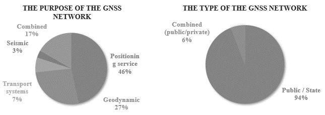
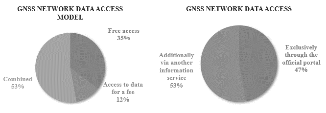
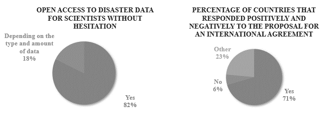
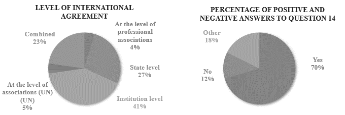
This research provided insight on policies for access to GNSS data on permanent networks in the event of a disaster in individual countries that participated in the survey. The survey and web research provided reliable data on the institutions that manage individual GNSS networks, the type and purpose of networks and portals through which network data can be accessed. Research has shown that the networks are mostly public and are mostly managed by public, state institutions. In all countries covered by the survey purpose of GNSS permanent networks is to provide data for positioning services. Many of them also use networks for geodynamic purposes, and some to support transport systems, agriculture, and seismology. The survey also includes official contacts for data users through which it is possible to contact the persons responsible for data management, as well as the types of network data access models describing whether the data usage service is charged or free. Only two countries (Hungary and Bosnia and Herzegovina) provide data only to registered users and their services of using data is possible only with payment of a fee. Some countries provide data to all registered users free of charge. An equal number of countries have stated that they provide data to registered users for a fee and allow certain groups of users to use the data free of charge. Following the previous response, a request was made to list groups of users who are exceptionally allowed to use GNSS data for free. It is noticeable in the answers that these are most often state, public institutions and organizations and universities that use the data for research and scientific purposes. The question of whether access to data is available only through the official portals of institutions that manage networks or also through other information services is almost the same percentage of both answers. Some countries provided direct Internet addresses through which the mentioned services can be accessed, while others explained that the availability of the portal depends on the type of user because they are most often managed privately. Almost all institutions answered that they do not apply a special model of access to data in case of disasters, except for Hungary and Bosnia and Herzegovina. Hungary shares data in case of natural disasters free of charge for research purposes with scientists from their country, and Bosnia and Herzegovina provide data exclusively to registered users. Further in the research, GNSS network managers were asked about their GNSS data access policies in the event of large-scale disasters and their willingness to introduce an international agreement, in a form of standard on open access to GNSS network data. The first question in this section received mainly affirmative answers in which the institutions stated that they were ready to share the data of the GNSS networks, which they manage, with scientists and researchers free of charge. They also stated that they would agree to the establishment of an international agreement for scientists and researchers that would be related to the availability and distribution of GNSS network data. Latvia stated that it would agree to such agreement if there is a registration of users, Serbia if the agreement would be approved by their government, and Estonia’s consent depends on the content and type of agreement. When asked which level of international agreement would be the most acceptable, 9 countries would agree to an agreement at the level of agencies, institutions, or companies operating networks, 4 institutions replied at the state level, Latvia would agree to an agreement at the level of the United Nations and Switzerland would agree to an agreement at the level of professional associations (geophysical, geodetic, etc.). The last question in the research was about readiness of making the data of their CORS stations for a certain period before and after the disaster available through a common international portal for researchers and scientists in the event of large-scale disasters. Most countries agreed to the proposal, In Serbia and Estonia it depends on the amount of data and the agreement from previous question, and Bosnia and Herzegovina did not give a clear answer. The Hungarian institution answered the last group of questions by e-mail, and they explained that they are not ready for an international agreement in the field of open data of GNSS permanent networks. However, in the event of natural disasters, they are willing to share GNSS RINEX data free of charge for research purposes only.
CONCLUSIONS
The focus of the research is on defining the global picture of the availability of GNSS permanent network data, with an emphasis on the openness of high-frequency network data. This type of data is crucial for research on seismological activities in earthquakes events that have an impact on the economic and social aspect of human lives. It was found that the data, which are publicly and free of charge available through Internet portals, are not sufficient for the study of seismological activities. Limited access to high-quality data of GNSS networks prompted this research and interest in creating arrangements to open access to data in the event of large-scale disasters for researchers and scientists. More accessible data would mean further progress in understanding, preparedness and responding to situations such as devastating earthquakes. To achieve our goal, a global survey was sent to the institutions responsible for managing GNSS permanent networks around the world. Given that out of 44 countries to which the survey was sent, 17 countries responded, and 15 of them are in Europe, we can draw conclusions more at the European level than at the global level, which was originally the goal. The first two groups of questions resulted in general information about GNSS networks and the data access model. Of greatest interest are the data collected in the last group of questions within the survey and relating to standardization of open access to data for scientists and researchers in case of disasters. All countries would agree to open GNSS network data in the event of a disaster for scientists and researchers without delay and payment. If an international agreement were proposed in the field of open data on GNSS networks for scientists in the event of natural disasters, the institutions would mostly be ready for this type of cooperation and agreement. Finally, it was investigated whether countries are willing in the event of a disaster to allow data to be uploaded through a common international portal for scientists and researchers. Mostly positive responses were received, except for some countries that are either not in favour of such a form of cooperation at all, or it depends on the already mentioned agreement and the type of data it would cover. Research results provides a basis, at European level, for a possible agreement to open high-frequency GNSS permanent network data for research purposes. Data availability is a key factor for all types of successful research as it greatly facilitates and speeds up the whole process. Access to data in case of natural disasters, such as earthquakes, for geodetic experts, but also other scientists, would mean further progress in understanding seismic activities. The development of an international portal through which scientists could download high-quality data would simplify research that might provide support in the future for better understanding of major earthquakes. The primary goal of the research has been met, a foundation has been created for future agreements with the countries that participated in the research, but also for all others that recognize the potential of open data of GNSS permanent networks.