Introduction
Nowadays children use computer technology every day and all the time. Cartographers should provoke their creativity and help them to study geography and history by using maps and atlases, which can be accessed/opened on their electronic devices. Maps for children should provide their users with the newest, updated information in the form of drawings and pictorial images of various subjects and phenomena as well as create a correct view of the world's geography and history. The goal of this research is to identifythe difficulties in cartographical education and remedy them using new technologies.
This would lead to improved education through the use of software and high-tech devices that make it more effective. However, students and teachers in schools and universities still encounter different types of difficulties. Many factors lead to distraction and loss of attention during class, a problem that students face and that can reduce their knowledge acquisition, skills and results. In addition, students attend classes with a lack of interest and excitement in the classroom taught. Some students also find visualising the explication of the lessons quite difficult. Therefore, dangerous mistakes can be made in laboratories that require practical implementation. For instance, some chemical interactions and errors in electrical experiments can lead to serious injuries in chemistry or physics classes. An experiment on attention problems at school shows that students expect teachers to use a variety of teaching methods in accordance with the students’ level (Cicekci, Sadik 2019). Another fact is that not all schools and universities cannot afford expensive experimental materials. In addition, it is difficult to provide tools and equipment all the time for visualizing the material taught in schools. Finally, the lack of resources plays a huge role in reducing the educational level of students with disabilities, as some of them find it difficult to interact and perform experiments easily due to their special needs. Therefore, in order to eliminate all these educational issues, technology must be integrated into its very core in order to build a more knowledgeable and educated society. Our task is to introduce a way to present geo-information to children in an interesting, innovative and modern way using all of the available educational materials.
To find a solution for our research topic we plan to use augmented reality (AR) as a technology which enhances reality with two- or three-dimensional computer-generated images (CGI), objects, and/or information, allowing the users to interact with them (Azuma 1997,Carmigniani et al 2010). AR can be interpreted “as a view of a physical, real world whose elements are integrated with a computer-generated sensory input” (Freina, Ott 2015). The goal is to “see and experience the real world mixed with different virtual objects without losing the sense of reality” (Persefoni, Tsinakos 2015). AR is a variation of virtual environment (VE) or virtual reality (VR). Ideally, VE technology immerses consumers in the virtual world without exposing them to the real world, while AR deals with both environments, and the user is able to see and display both the virtual and the real environment (Azuma 1997). In 1994, Milgram and Kishino defined the continuum of AR and VR. AR is located between the recommended and the virtual environment and the as-is state in the neighbourhood, called "mixed reality" (Milgram, Kishino 1994). Mixed reality integrates digital information into the relevant environment. In addition to whatAzuma (1997) says, AR provides both types of objects in 2D or 3D, resulting in real-time interaction that reflects the mixed reality in the AR continuum ofof Milgram and Kishino (1994). Users will begin to experience a virtual surround environment when the point moves to the right, resulting in a virtual environment. Real objects are added to virtual ones within the virtual environment, which complements the background. Unlike the dot on the left, AR offers a range of digital objects such as audio, video, haptic touch and / or images that can be imposed on the real environment.
In a broader context, AR is an experience for students and engineers to provide invisible interfaces and improve user interaction with the real world. Instead of interfaces available on computers, a graphical user interface (GUI) could be provided and there is a clear differentiation between digital screens of the domains and real physical worlds.
Virtual implementation is a different approach from AR, where the user wears a display mounted on the head and the real world is completely replaced by the virtual environment. The user is completely isolated in the display and isolated from the real world. This is the biggest difference between the virtual and the augmented reality (Billinghurst et al 2015).
Virtual and augmented reality in cartographical education
Technology is reaching new peaks on a daily basis and we are very familiar with 3D cartoons, movies, games. Almost everyone enjoys the 3D world of entertainment, as it feels more realistic than its 2D equivalent and provides more detail and information than 2D, such as shadows, depth of field, object structure and more. In the same way, the 3D approach can be applied for educational purposes, which ultimately help to increase the speed of learning and to easily understand difficult concepts in a short period of time. Educational systems cannot be limited to context and pictures and must focus on digitalization. Digital applications in education make it more interesting, engaging and helps to understand, memorize and learn complex topics. Chemistry is an interesting subject, but it is usually difficult for some students to understand it and its various concepts. For instance, it can be difficult for the student to understand the atomic structure, the molecular structure and how the bond is formed as an ionic bond, a covalent bond, a coordinate covalent and a polar bond. In the same way, students struggle in understanding different forms of compounds and different complex experiments (Alam at al. 2020). An AR app is a better way to learn and understand the real environment. Teachers can easily explain difficult concepts by designing advanced experiments and describing the concept with a voice that supports all three types of learning styles (visual, auditory and kinaesthetic).Orator.bg (2021) shows in its study that "about 40% of people perceive information visually, 40% - kinaesthetically, and the remaining 20% - auditory and tactile."
There are many factors in improving the quality of education. These include the ability and motivation of individual students to learn at their own pace, as well as approaches to learning, including mutual education. In order to improve the technologies applied in the learning and teaching experience, field-specific, pedagogical and psychological aspects must be considered (Markwell 2003). AR on mobile devices is still relatively new and therefore lacks research conducted in this area in education, unlike AR using computers and glasses (Hamilton 2021).
AR environments of mobile devices are evolving and offer great potential in terms of education and learning. AR has been shown to be a tool that can enhance learning motivation (Balog, Costin 2010). In pedagogy, it is important to enhance/increase student satisfaction through their involvement in learning activities with significant material that generates positive interest, learning time and place of choice and individual pace of learning (Piccoli et al 2001).
AR has the potential to revolutionize the place, judgment and effectiveness of education by combining new and additional ways of learning (Antonioli et al 2014).Dunleavy and Dede (2014) found that AR applications in education are increasingly related to teamwork skills (thus preserving the social dimension), but cognitive overload and concrete performance remain a challenge.Di Serio et al (2013) recruited 69 average students to perform a set of AR-based learning activities, finding that their motivation increased more than in the control group. Introducing the Zspace,Noor and Aras (2015) argue that AR can trigger multimodal and multi-user learning.
The last few years have seen problems with AR in terms of equipment, development costs, maintenance, and conflicts with emerging technologies. Currently, this shortcoming is solved in one way or another, but according toBillinghurst and Dünser (2012) this technology is still lacking due to a shortage of non-specialists with high skills to develop the subject content. High skills in 3D modelling, programming knowledge and detailed understanding of the subject of content development are required (Dünser et al 2012). Therefore, researchers believe that more research and development in the field of AR is needed to be able to apply it in education.
In the next chapter the authors will explain how the AR was employed in the educationprocess. It was based on a paper school atlas on geography. The aim was to add new information, update the old and present it using 3D models, simulations and animations.
Creation of AR content
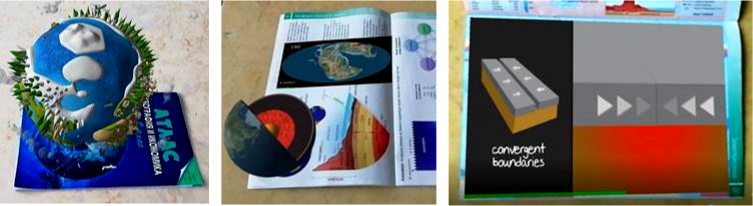
Choosing the type of Augmented Reality is one of the first steps in creating an AR application. Marker-based AR is the most suitable type of AR to add to a school atlas. It requires a special visual object which can be anything from a printed Quick Response (QR) code to special signs. Marker-based applications use a camera on the device to distinguish a marker from any other real-world object and it overlays information on top of this marker. Markers are labels that contain a coloured or black and white pattern recognized by the AR application through the camera of the device. The AR device in some cases also calculates the position and orientation of a marker to position the content. The different pages of the school atlas are used as different markers in this project (Fig. 1a, b).
Fig. 1a, b. Pages from the atlas used as markers (Bandrova 2017) / Slika 1a, b. Stranice iz atlasa upotrijebljene kao markeri (Bandrova 2017)
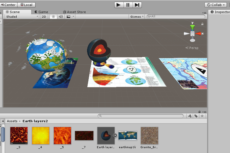
The AR content is the augmented information which will be used together with the basic information, in our case – a paper version school geography atlas. The augmented information can be anything from 2D and 3D models to animation and video. In this project two 3D models with complex animations and 3D game-like interactions and two videos are augmented using Vuforia in combination with Unity (Fig. 2).
Fig. 2. Unity environment used for technology creation
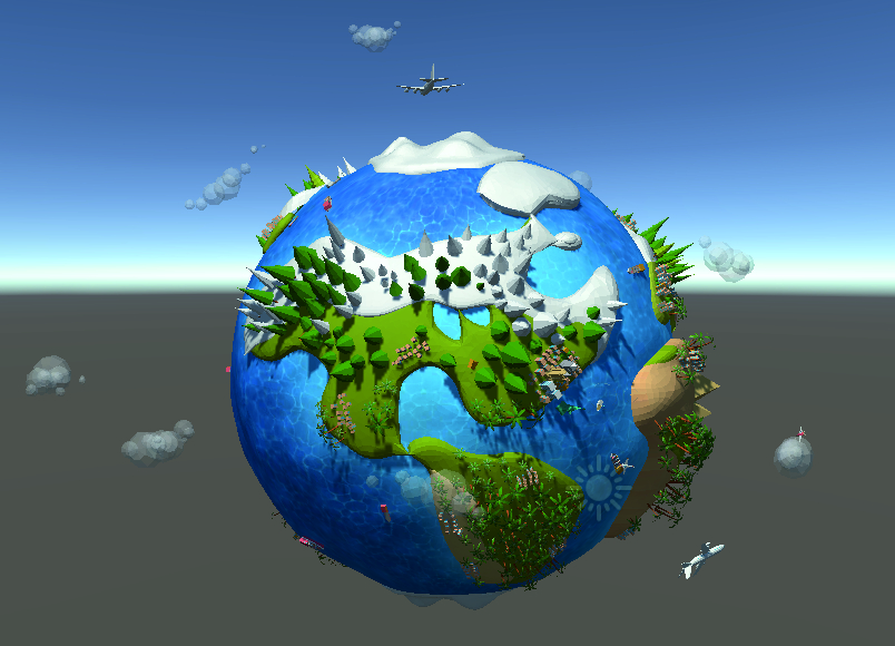
The first AR content is a 3D model of the planet Earth and it is added to the cover of the atlas to catch the attention of the kids at first sight (Fig. 3).
Fig. 3. 3D model of the planet Earth (Moek A, 2019)
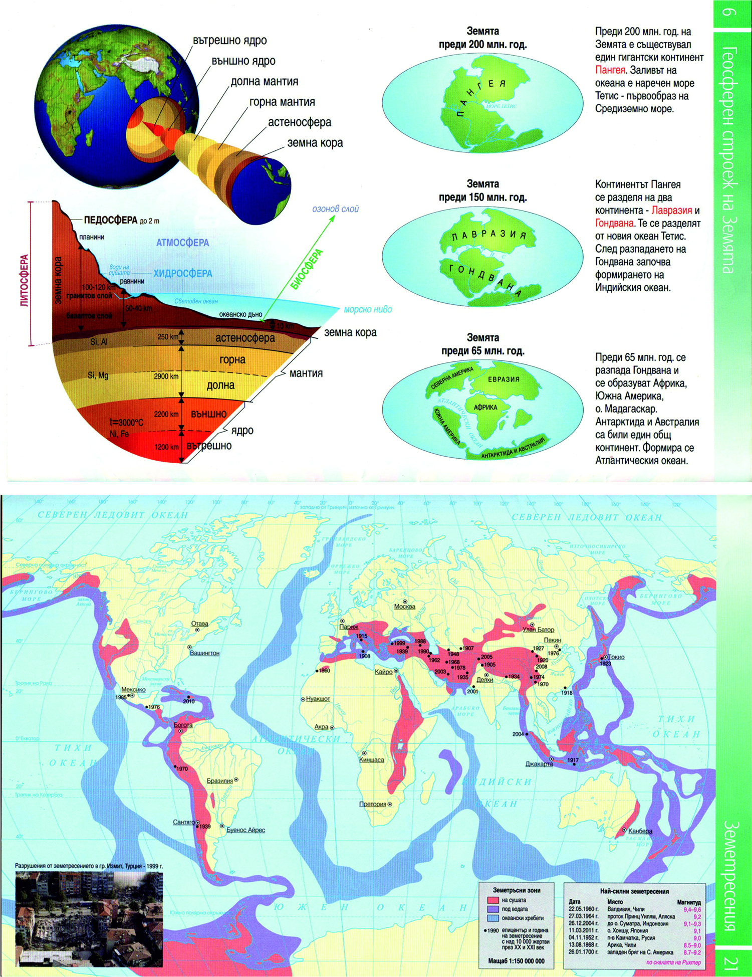
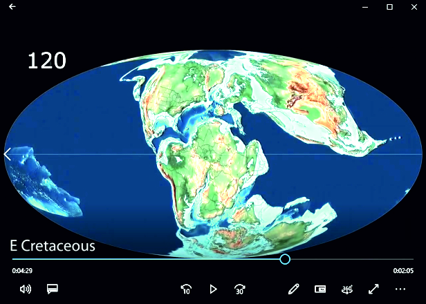
On the next selected page, a 3D model of the Earth structure (Fig. 4) is added for better visualization and understanding of the graphic presented in the atlas along with a short video (Fig. 5) supplementing a diagram for the shape of the continents, showing the plate tectonic and paleogeographic evolution of the Earth dating back to 540 million years.
Fig. 4. 3D model of the Earth structure
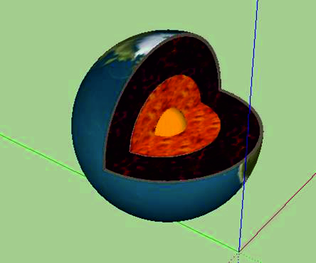
Fig. 5. A video frame showing the change in the shape of the continents over millions of years (Scotese 2016)
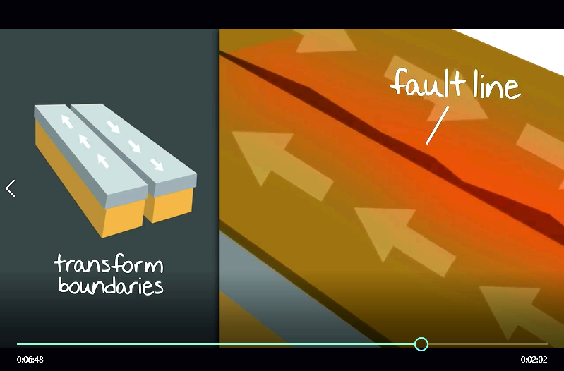
The final selected page from the atlas used in this project shows the earthquake zones on land, under water and the ocean ridges. Here the augmented information is a short video lesson showing what causes earthquakes and their consequences (Fig. 6).
Fig. 6. Plate tectonics theory lesson (Graham 2016)
These final work steps are followed in creating the end product AR mobile application:
Comparison of all elements;
Choice of projection, scale, scene and range;
Additional effects and animations;
Rendering.
Difficulties applying AR to the school atlas
The pages of the paper atlas are well recognized, and the tracking of the camera's movements is effective, so the added information is presented almost immediately on the tablet. However, digital visualizations begin to flicker when the angle between the camera and the paper map becomes too sharp. This problem is mentioned in the Vuforia developer portal, but no solution is recommended (Vuforia 2021).
Distorted printed atlas sheets are another problem, as they cause incorrect positioning of the added content. This is due to the assumption of flatness for the purpose of the image, which is not possible when maps are spread over two pages. The virtual objects appear to be placed on the largest recognized portion of the map by the Vuforia Engine. In the case of double-sided maps, positioning works well on one page, while there is an error in height and scale on the other. Other authors (Schnürer et al 2020) have discovered the same problem. Overlap of map elements may occur when the distance between the tablet and the printed map increases. Applying generalization depending on the viewing distance can reduce the congestion of these elements on the map.
Knowing the problems, we try to avoid the disadvantages of AR technology and present the content to students in an attractive and understandable way. Because of this we have made an experiment to gauge their understanding of new information presented in such an innovative way.
Survey with students on their understanding of augmented reality school atlas topics
In order to study how the school atlas with AR is perceived by the students, a class was conducted with 30 children, aged 9-10 years, from Grade 3 from the 125th school in Sofia. The aim was to investigate how students most easily and effectively perceive new information by measuring several variables such as motivation, commitment, perception and effectiveness of learning. The specific focus was the potential use of Augmented Reality in the school system in Bulgaria.
An approach was sought for presenting complex and additional information from the Grade 8 Atlas to Grade 3 students. The aim was to understand whether students would be able to handle complex material with the help of AR, which would help read and facilitate understanding the information in the atlas. The method of presenting information for higher grade lessons to younger students is not a new one.Jirout and Newcombe (2014) use scaled maps as an opportunity to develop spatial thinking in 4–5-year-olds.Nunez and Szabo (2011) support education on a website about maps for children and regularly update its content.
The children were divided into two groups of 15. With the help of a student atlas, a short lesson was given on the changing shape of the continents during the different stages of the Earth's history, the reasons for these changes and the reason for the occurrence of earthquakes. Then, with the help of the created mobile application for augmented reality, additional information was added to the school atlas. The mobile application was installed on a tablet, through which the added information was visualized – two 3D models, a short video, supplementing the diagram in the school atlas for the shape of the continents and a short video tutorial showing what causes earthquakes and their consequences (Fig. 7).
Fig. 7a,b,c. Visualization of the AR content on the base of a paper version school atlas
The children were acquainted with this new technology, it was explained to them how it works, and the lesson was enriched. A short test was created, with questions tailored to the students’ age and their previous knowledge.
The first question ”Do you use maps in ‘Man and Society’ lessons?” aims to draw children's attention to something familiar, namely ‘Man and Society’ lessons. The second question, "List the continents of the world" is to assess the students' current knowledge. Question 3, “Was the shape of the continents different millions of years ago?” is the first main question. When we receive the correct answer to question 3, it will consider the data from question 4, “How did you know that the shape of the continents has changed?” Here three possible answers are available ("From the diagram in the atlas", "from the teacher’s lesson" and "from the video on the tablet"). The student can choose all three answers. Question 5, “What is the cause of earthquakes?” is the second main question and with a correct answer the results of the last question 6 are considered, where again the student can choose all three answers.
The purpose of this test was to assess the acquired new knowledge and in particular the way in which students learned: whether they find learning with this new technology really interesting; whether it complements the knowledge of the standard lesson; and, finally, its future integration into the curriculum. After getting acquainted with the lesson and with additional information using the new augmented reality technology, all children from both groups complete the test on their own (Fig. 8).
Figure 8a,b. Children fill in the test and one of their answers (in Bulgarian)
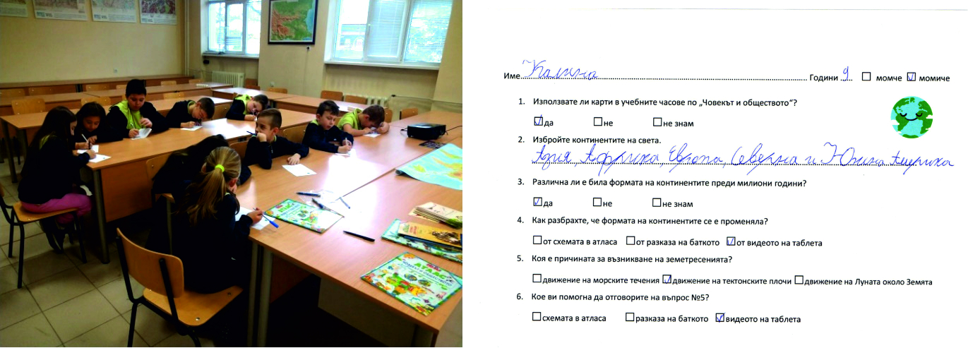
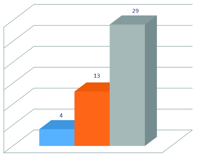
The results are processed and presented in the figures below. To the first basic question, "Was the shape of the continents different millions of years ago?", all students answered in the affirmative, and 97% of them (29 children out of 30) said they learned this thanks to the new technology - the added video visualised on the tablet. 43% of them (13 children) cite the teacher's explanations as the reason and 13% (4 children) choose the atlas scheme as their answer (Fig. 9).
Figure 9. Results from the answers to the first main question, “Was the shape of the continents different millions of years ago?”
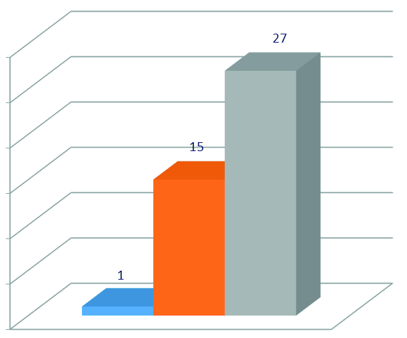
To the second main question "What is the cause of earthquakes?”, 97% of all students answer positively. 90% of them (27 children out of 30) say they learned this thanks to the new technology - the added video, visualized via the tablet. 50% of them (15 children) cite the teacher's explanations as the reason, and only 3% (1 child) choose the atlas scheme as the answer (Fig. 10).
Figure 10. Results from the answers to the second main question, “What is the cause of earthquakes?”
In our research we combined specific questions for easy understanding of complicated information. The results show the positive result of this approach. Some authors, such asBartz (1971), proposed an approach to designing maps for children, in which the visual elements are related to intellectually presented spatial information associated with specific tasks for using the map. Nowadays this is not that difficult to achieve by using AR technology. The achievement in this experiment shows how cartographers can use new technologies and improve traditional school cartography. This is an answer toNunez’s (2020) question as to how we can help children to better understand maps and incite their interest in them while increasing the students' learning ability like in other atlas use experiments (Bugdayci, Silvi 2021).
Conclusions
Creating an AR application is an extremely complex and time-consuming process. AR has extensive application and can be of benefit for many different users. The challenges in creating and adding augmented reality to school atlases still include not only data collection, modelling, design and visualization, but the use of AR as well in a useful way from an educational point of view to become a tool to increase motivation for learning, a tool for quality teaching and learning. The results of the experiment show that children need information to be presented in an interesting and more understandable way, to motivate them and to attract their attention, and this new technology in combination with accepted teaching methods is a perfect way to accomplish this.
This project provided evidence that students could understand correctly very difficult geographical topics. Another benefit is that students wanted to learn more and look for additional information on the given topic. Moreover, they had an interest in the technology we used to present the information to them. Their curiosity increased towards acquiring new knowledge, as well as towards practical skills for the development and use of new technologies.
Our future tasks are to expand this project with more topics for information visualization, not only in school cartography but also for other needs and users of maps and cartographical products.
Uvod
Današnja djeca neprestano koriste računalnu tehnologiju. Kartografi bi trebali provocirati njihovu kreativnost i pomoći im u proučavanju geografije i povijesti upotrebom karata i atlasa koji se mogu koristiti na njihovim računalnim uređajima. Karte za djecu trebale bi svojim korisnicima pružiti najnovije ažurirane informacije crtežima, slikama različitih predmeta i pojava te stvoriti ispravan pogled na svjetsku geografiju i povijest. Ovim istraživanjem pokušavamo pronaći poteškoće u kartografskom obrazovanju i poboljšati ga nekom od novih tehnologija.
Obrazovanje ćemo unaprijediti upotrebom softvera i visokotehnoloških uređaja koji ga čine učinkovitijim. Međutim, različite vrste poteškoća još uvijek ometaju učenike i nastavnike u školama, pa čak i na sveučilištima. Zbog mnogih čimbenika ometanje i gubitak pažnje tijekom nastave neki su od problema s kojima se učenici susreću i koji mogu umanjiti njihovo znanje, vještine i rezultate. Osim toga, učenici pohađaju nastavu bez interesa i uzbuđenja u učionici. Također je teško vizualizirati objašnjenje lekcija za neke učenike. Stoga se u laboratorijima mogu napraviti opasne pogreške koje zahtijevaju praktičnu provedbu. Na primjer, neke kemijske interakcije i pogreške u električnim eksperimentima mogu dovesti do ozbiljnih ozljeda u nastavi kemije ili fizike. Eksperiment o problemima pažnje u školi pokazuje da učenici očekuju od učitelja da koriste različite metode poučavanja u skladu s učeničkom razinom (Cicekci, Sadik 2019). Druga je činjenica da si neke škole i sveučilišta ne mogu osigurati skupe eksperimentalne materijale. Osim toga, teško je osigurati alate i opremu za vizualizaciju gradiva koje se stalno uči u školama. Konačno, nedostatak resursa igra veliku ulogu u smanjenju obrazovne razine učenika s teškoćama, budući da je nekima od njih teško komunicirati i lako izvoditi eksperimente zbog njihovih posebnih potreba. Stoga, kako bi se eliminirali svi ti obrazovni problemi i izgradilo obrazovanije društvo, tehnologija se mora integrirati u obrazovanje. Naš je zadatak prezentirati djeci geoinformacije na zanimljiv, inovativan i moderan način koristeći sve dostupne edukativne materijale.
Kako bismo pronašli rješenje za svoju istraživačku temu, planiramo koristiti proširenu stvarnost (augmented reality - AR) kao tehnologiju koja poboljšava stvarnost dvodimenzionalnim ili trodimenzionalnim računalno generiranim slikama (computer-generated images - CGI), objektima i/ili informacijama i omogućuje korisnicima interakciju s njima (Azuma 1997,Carmigniani et al 2010). AR se može tumačiti kao „pogled na fizički, stvarni svijet čiji su elementi integrirani s računalno generiranim senzorskim ulazom" (Freina, Ott 2015). Cilj je "vidjeti i doživjeti stvarni svijet pomiješan s različitim virtualnim objektima bez gubljenja osjećaja stvarnosti" (Persefoni, Tsinakos 2015). AR je varijacija virtualnog okruženja (virtual environment - VE) ili virtualne stvarnosti (virtual reality - VR). U idealnom slučaju VE tehnologija uranja potrošače u virtualni svijet bez izlaganja stvarnom svijetu, dok se AR bavi obama okruženjima, pri čemu korisnik može vidjeti i prikazati i virtualno i stvarno okruženje (Azuma 1997). Milgram i Kishino definirali su 1994. godine kontinuum AR i VR. AR se nalazi između preporučenog i virtualnog okruženja i stanja u susjedstvu nazvanog "mješovita stvarnost" (Milgram, Kishino 1994). Mješovita stvarnost integrira digitalne informacije u relevantno okruženje. Osim onoga što kažeAzuma (1997), AR pruža obje vrste objekata u 2D ili 3D, što rezultira interakcijom u stvarnom vremenu koja odražava miješanu stvarnost u AR kontinuumuMilgrama i Kishinoa (1994). Korisnici će početi doživljavati virtualno surround okruženje kada se točka pomakne udesno, što dovodi do virtualnog okruženja. Stvarni se objekti dodaju virtualnima unutar virtualnog okruženja, što nadopunjuje pozadinu. Za razliku od točke na lijevoj strani, AR nudi niz digitalnih objekata kao što su audio, video, haptički dodir i/ili slike koji se može nametnuti stvarnom okruženju.
U širem kontekstu AR je iskustvo za studente i inženjere koje pruža nevidljiva sučelja i poboljšava interakciju korisnika sa stvarnim svijetom. Umjesto sučelja dostupnih na računalima moglo bi se osigurati grafičko korisničko sučelje (GUI) gdje postoji jasna razlika između digitalnih zaslona domena i stvarnih fizičkih svjetova.
Drugačiji je pristup kroz virtualnu primjenu, pri čemu korisnik nosi zaslon postavljen na glavi, a stvarni svijet u potpunosti zamjenjuje virtualno okruženje. Korisnik je potpuno izoliran na zaslonu i izoliran od stvarnog svijeta. To je najveća razlika između virtualne i proširene stvarnosti (Billinghurst et al 2015).
Virtualna i proširena stvarnost u kartografskom obrazovanju
Tehnologija iz dana u dan dostiže svoj novi vrhunac i dobro poznajemo 3D crtiće, filmove i igrice. Gotovo svi uživaju u 3D svijetu zabave jer se čini realističnijim od svoga 2D ekvivalenta i pruža više detalja i informacija od 2D, kao što su sjene, dubina polja, struktura objekta i još mnogo toga. Na isti se način 3D pristup može primijeniti u obrazovne svrhe, što u konačnici pomaže u povećanju brzine učenja i lakšem razumijevanju teških pojmova u kratkom vremenskom razdoblju. Obrazovni sustavi ne mogu biti ograničeni na kontekst i slike i moraju se usredotočiti na digitalizaciju. Digitalni je svijet obrazovanja korisniji jer je zanimljiviji, privlačniji i pomaže razumjeti, zapamtiti i naučiti složene teme. Kemija je zanimljiv predmet, ali je nekim učenicima obično teško razumjeti njezine različite pojmove. Osim toga, učeniku postaje teško razumjeti strukturu atoma, molekularnu strukturu i način na koji nastaje ionska veza, kovalentna veza, koordinatna kovalentna i polarna veza. Na isti se način učenici bore s razumijevanjem različitih oblika spojeva i različitih složenih eksperimenata (Alam i sur. 2020). AR aplikacija je bolji način za učenje i razumijevanje stvarnog okruženja. Učitelji mogu jednostavno objasniti teške koncepte osmišljavanjem naprednih eksperimenata i opisivanjem koncepta glasom koji podržava sve tri vrste stilova učenja (vizualni, slušni i kinestetički).Orator.bg (2021) u svojoj studiji pokazuje da "oko 40% ljudi informacije percipira vizualno, 40% - kinestetički, a preostalih 20% - slušno i taktilno".
Mnogo je čimbenika za poboljšanje kvalitete vježbanja. To su npr. sposobnost i motivacija pojedinih učenika da uče vlastitim tempom, kao i pristupi učenju, uključujući grupni rad. Da bi se poboljšale tehnologije za primjenu iskustva učenja i poučavanja, moraju se uzeti u obzir specifični pedagoški i psihološki aspekti (Markwell 2003). AR na mobilnim uređajima još je uvijek relativno nov i stoga nema istraživanja provedenih u ovom području u obrazovanju, za razliku od AR-a s pomoću računala i naočala (Hamilton 2021).
AR okruženja mobilnih uređaja razvijaju se i nude veliki potencijal u smislu obuke i učenja. AR se pokazao kao alat koji može poboljšati motivaciju za učenje (Balog, Costin 2010). U području poučavanja i učenja važno je procijeniti zadovoljstvo učenika uključenošću u aktivnosti učenja takvim materijalom koji stvara pozitivan interes, omogućuje izbor vremena i mjesta učenja te individualni tempo učenja (Piccoli et al 2001).
AR ima potencijal za snažnu promjenu mjesta, prosudbe i učinkovitosti obuke kombiniranjem novih i dodatnih načina učenja (Antonioli et al 2014).Dunleavy i Dede (2014) otkrili su da su AR aplikacije u obrazovanju sve povezanije s vještinama timskog rada (čime se čuva društvena dimenzija), ali kognitivno preopterećenje i konkretna izvedba ostaju izazov.Di Serio i sur. (2013) regrutirali su 69 prosječnih učenika za izvođenje niza aktivnosti učenja temeljenih na AR-u, otkrivši da se njihova motivacija povećala više nego u kontrolnoj skupini. Predstavljajući uređaj Zspace,, Noor i Aras (2015) tvrde da AR može potaknuti multimodalno učenje i učenje s više korisnika.
Posljednjih nekoliko godina uočeni su problemi s AR-om u smislu opreme, troškova razvoja, održavanja i sukoba s novim tehnologijama. Trenutačno je taj nedostatak riješen na ovaj ili onaj način, ali, premaBillinghurstu i Dünseru (2012), ta tehnologija još uvijek nedostaje zbog nedostatka specijalista s potrebnim vještinama za razvoj sadržaja predmeta. Potrebne su znatne vještine u 3D modeliranju, znanje programiranja i detaljno razumijevanje predmeta razvoja sadržaja (Dünser i sur. 2012). Stoga istraživači vjeruju da je za obrazovanje potrebno više istraživanja i razvoja u području AR-a.
U sljedećem će poglavlju autori precizirati kako je AR upotrijebljen u procesu obuke. Temelji se na papirnatom školskom atlasu iz geografije. Cilj je dodati nove informacije, ažurirati stare te prezentirati informacije 3D modelima, simulacijama i animacijama.
Kreiranje sadržaja AR-a
Odabir vrste proširene stvarnosti jedan je od prvih koraka stvaranja AR aplikacije. AR na temelju markera najprikladniji je tip AR-a za dodavanje u školski atlas. Zahtijeva poseban vizualni objekt koji može biti bilo što, od ispisanog koda za brzi odgovor (Quick Response - QR) do posebnih znakova. Aplikacije temeljene na markeru koriste kameru na uređaju za razlikovanje markera od bilo kojeg drugog stvarnog objekta i prekrivaju informacije na vrhu ovog markera. Markeri su naljepnice koje sadrže obojeni ili crno-bijeli uzorak koji prepoznaje AR aplikacija putem kamere uređaja. U nekim slučajevima AR uređaj također izračunava položaj i orijentaciju markera za pozicioniranje sadržaja. Različite se stranice školskog atlasa koriste kao različite oznake u ovom projektu (slike 1a, b).
AR sadržaj je proširena informacija koja će se koristiti zajedno s temeljnom, u našem slučaju papirnatom verzijom školskog atlasa iz geografije. Proširene informacije mogu biti bilo što, od 2D i 3D modela do animacije i videa. U ovom su projektu dva 3D modela sa složenim animacijama i interakcijama nalik 3D igrici i dva videa uvećana s pomoću Vuforije u kombinaciji s Unityom (Fig. 2).
Prvi AR sadržaj je 3D model planeta Zemlje koji je dodan na naslovnicu atlasa kako bi na prvi pogled privukao pažnju djece (slika 3).
Na sljedećoj je odabranoj stranici dodan 3D model strukture Zemlje (slika 4) za bolju vizualizaciju i razumijevanje grafike predstavljene u atlasu i kratki video (slika 5) koji dopunjava dijagram oblika kontinenata i prikazuje tektonsku i paleogeografsku evoluciju Zemlje unatrag 540 milijuna godina.
Posljednja odabrana stranica iz atlasa u ovom projektu prikazuje zone potresa na kopnu, pod vodom i grebene oceana. Ovdje je proširena informacija kratka video lekcija koja pokazuje što uzrokuje potrese i što su njihove posljedice (slika 6).
U izradi krajnjeg proizvoda AR mobilne aplikacije slijede završni radni koraci:
usporedba svih elemenata
izbor projekcije, mjerila, scene i raspona
dodatni efekti i animacije
renderiranje.
Poteškoće u primjeni AR-a na školski atlas
Stranice se papirnatog atlasa dobro prepoznaju i praćenje kretanja kamere je učinkovito pa se dodane informacije gotovo odmah prikazuju na tabletu. Međutim, digitalne vizualizacije počinju treperiti kada kut između kamere i papirne karte postane preoštar. Taj se problem spominje na portalu za programere Vuforia, ali se ne preporučuje rješenje (Vuforia 2021).
Deformirani otisnuti listovi atlasa još su jedan problem jer uzrokuju pogrešno pozicioniranje dodanog sadržaja. To je zbog pretpostavke ravne slike koju ne daju karte smještene na dvjema stranicama. Čini se da Vuforia Engine postavlja virtualni objekt na najveći prepoznati dio karte. U slučaju karata na dvjema stranicama pozicioniranje dobro funkcionira na jednoj stranici, dok je na drugoj stranici greška u visini i mjerilu. Isti su problem otkrili i drugi autori (Schnürer i sur. 2020). Do preklapanja elemenata karte može doći kada se poveća udaljenost između tableta i otisnute karte. Primjena generalizacije ovisno o udaljenosti gledanja može smanjiti zagušenje ovih elemenata na karti.
Poznajući probleme, nastojimo izbjeći nedostatke AR tehnologije i prezentirati sadržaj učenicima na atraktivan i razumljiv način. Radi toga smo napravili eksperiment u skladu s njihovim razumijevanjem novih informacija prezentiranih na inovativan način.
Anketiranje učenika o njihovom razumijevanju tema školskog atlasa proširene stvarnosti
Da bi se proučilo kako učenici percipiraju školski atlas s AR-om, održan je sat sa 30 djece, uzrasta 9 - 10 godina, iz trećeg razreda 125. škole u Sofiji. Željeli smo istražiti kako učenici najlakše i najučinkovitije percipiraju nove informacije mjerenjem nekoliko varijabli, kao što su motivacija, predanost, percepcija i učinkovitost učenja. Poseban je fokus bio potencijalna upotreba proširene stvarnosti u školskom sustavu u Bugarskoj.
Tražen je pristup za prezentiranje složenih i dodatnih informacija iz atlasa za 8. razred učenicima 3. razreda. Cilj je razumjeti hoće li studenti moći baratati složenim materijalom uz pomoć AR-a koji bi pomogao čitanju i lakšem razumijevanju informacija u atlasu. Način prezentiranja informacija za nastavu viših razreda najmlađim učenicima nije nov.Jirout i Newcombe (2014) koriste karte u mjerilu kao priliku za razvoj prostornog razmišljanja djece od 4-5 godina.Nunez i Szabo (2011) podržavaju edukaciju s pomoću web stranice o kartama za djecu i redovito ažuriraju njezin sadržaj.
Djeca su podijeljena u dvije grupe od po 15 osoba. Uz pomoć školskog atlasa održana je kratka lekcija o promjeni oblika kontinenata u različitim fazama Zemljine povijesti, razlozima tih promjena i razlozima nastanka potresa. Zatim su uz pomoć izrađene mobilne aplikacije za proširenu stvarnost dodane dodatne informacije u školski atlas. Mobilna je aplikacija instalirana na tablet putem kojega su vizualizirane dodane informacije – dva 3D modela, kratki video, dopuna dijagrama u školskom atlasu za oblik kontinenata te kratki video tutorial koji prikazuje uzroke potresa i njihove posljedice (slika 7).
Djeca su upoznata s novom tehnologijom, pojašnjeno im je kako funkcionira te je nastava obogaćena. Napravljen je kratki test s pitanjima prilagođenima učeničkoj dobi i njihovu predznanju.
Prvo pitanje Koristite li se kartama u nastavi predmeta Čovjek i društvo? imalo je za cilj skrenuti pozornost djece na nešto poznato, a to je predmet Čovjek i društvo. Drugim pitanjem, Navedite kontinente svijeta. željelo se procijeniti trenutačno znanje učenika. Prvo glavno pitanje bilo je Je li oblik kontinenata bio drugačiji prije milijun godina?. Kada dobijemo točan odgovor na treće pitanje, u obzir će se uzeti podatci iz pitanja broj 4 Kako ste znali da se oblik kontinenata promijenio? Ovdje su dostupna tri moguća odgovora ("Iz dijagrama u atlasu", "iz lekcije učitelja" i "iz videa na tabletu"). Učenik može izabrati sva tri odgovora. Peto pitanje Što je uzrok potresa? drugo je glavno pitanje i s točnim odgovorom u obzir se uzimaju rezultati posljednjeg, šestog pitanja, gdje opet student može izabrati sva tri odgovora.
Svrha ovoga testa bila je procijeniti stečena nova znanja, a posebno način na koji su učenici naučili je li poučavanje ovom novom tehnologijom doista zanimljivo, nadopunjuje li znanje standardnog sata i njegovu buduću integraciju u nastavni program. Nakon predavanja i dodatnih informacija s pomoću nove tehnologije proširene stvarnosti sva djeca iz obiju grupa samostalno odgovaraju na pitanja u testu (slika 8).
Rezultati su obrađeni i prikazani na slikama u nastavku. Na prvo osnovno pitanje Je li oblik kontinenata bio drugačiji prije milijune godina? svi su učenici odgovorili potvrdno, a njih 97% (29 djece od 30) reklo je da su to naučili zahvaljujući novoj tehnologiji - videu na tabletu. Njih 43% (13 djece) kao razlog navodi objašnjenja učitelja, a 13% (četvero djece) odabire atlasnu shemu za odgovor (slika 9).
Na drugo glavno pitanje Što je uzrok potresa? 97% svih učenika odgovorilo je pozitivno. Njih 90% (27 djece od 30) reklo je da su to naučili zahvaljujući novoj tehnologiji - dodanom videu, vizualiziranom putem tableta. Njih 50% (15 djece) kao razlog navodi objašnjenja učitelja, a samo 3% ili 1 dijete za odgovor bira shemu atlasa (slika 10).
U našem smo istraživanju kombinirali specifična pitanja za lakše razumijevanje kompliciranih informacija. Rezultati pokazuju pozitivan rezultat ovog pristupa. Neki autori, poputBartza (1971), predložili su pristup oblikovanju karata za djecu u kojem su vizualni elementi povezani s intelektualno prezentiranim prostornim informacijama vezanima uz specifične zadatke za korištenje karte. Danas to nije tako teško postići korištenjem AR tehnologije. Postignuće u ovom eksperimentu pokazuje kako kartografi koriste nove tehnologije i poboljšavaju tradicionalnu školsku kartografiju. To je odgovor na pitanjaNuneza (2020) kako možemo pomoći djeci da bolje razumiju karte i probude svoje zanimanje te da povećamo sposobnost učenja učenika kao u drugim eksperimentima o upotrebi atlasa (Bugdayci, Silvi 2021).
Zaključci
Izrada AR aplikacije iznimno je složen i dugotrajan proces. AR ima bogatu primjenu i može biti korisna mnogim različitim korisnicima. Izazovi u stvaranju i dodavanju proširene stvarnosti u školski atlas još uvijek nisu samo prikupljanje podataka, modeliranje, dizajn i vizualizacija, već i korištenje AR-a na koristan način s obrazovne točke gledišta kako bi postao alat za povećanje motivacije za učenje, alat za kvalitetno poučavanje i učenje. Rezultati eksperimenta pokazuju da djeci informacije trebaju biti prezentirane na zanimljiv i razumljiv način, motivirati ih i privući njihovu pozornost, a nova je tehnologija u kombinaciji s prihvaćenim metodama poučavanja savršen način za to.
Ovaj je projekt pokazao da učenici mogu na ispravan način razumjeti vrlo teške geografske teme. Druga je dobit što učenici žele naučiti još više i traže dodatne informacije o zadanoj temi. Štoviše, oni su zainteresirani za tehnologiju kojom smo im predstavili informacije. Povećava se njihova znatiželja prema stjecanju novih znanja, ali i praktičnim vještinama za razvoj i upotrebu novih tehnologija.
